FAA INFORMATION EFFECTIVE 09 JULY 2026
Location
| FAA Identifier: | GAL |
| Lat/Long: | 64-44-10.2830N 156-56-04.3970W
64-44.171383N 156-56.073283W
64.7361897,-156.9345547
(estimated) |
| Elevation: | 153.7 ft. / 46.8 m (surveyed) |
| Variation: | 13E (2020) |
| Time zone: | UTC -8 (UTC -9 during Standard Time) |
| Zip code: | 99741 |
Airport Operations
| Airport use: | Open to the public |
| Activation date: | 09/1947 |
| Control tower: | no |
| ARTCC: | ANCHORAGE CENTER |
| FSS: | FAIRBANKS FLIGHT SERVICE STATION [907-474-0788] |
| NOTAMs facility: | GAL (NOTAM-D service available) |
| Attendance: | OCT-APR MON-FRI 0600-1700 |
| Wind indicator: | yes |
| Segmented circle: | yes |
| Lights: | ACTVT MIRL RWY 08/26 - CTAF. |
| Beacon: | white-green (lighted land airport)
Operates sunset to sunrise. |
| Landing fee: | yes |
Airport Communications
| CTAF: | 123.0 |
| WX AWOS-3P: | 132.525 (907-656-2483) |
- APCH/DEP SVC PRVDD BY ANCHORAGE ARTCC ON FREQS 127.0/290.2 (GALENA RCAG).
- MIL CONTRACTOR CALL SPACE MARK ON 391.2 FOR ALL SERVICES.
- COMMUNICATIONS PRVDD BY FAIRBANKS FSS ON FREQ 122.2 (GALENA RCO).
Nearby radio navigation aids
| VOR radial/distance | | VOR name | | Freq | | Var |
|---|
| GALr256/4.0 | | GALENA VOR/DME | | 114.80 | | 12E |
Airport Services
| Fuel available: | 100LL JET-A |
| Parking: | hangars and tiedowns |
Runway Information
Runway 8/26
| Dimensions: | 6000 x 100 ft. / 1829 x 30 m |
| Surface: | asphalt, in fair condition |
| Weight bearing capacity: | | PCN 62 /F/C/X/T | | Single wheel: | 110.0 | | Double wheel: | 144.0 | | Double tandem: | 240.0 |
|
| Runway edge lights: | medium intensity |
| Operational restrictions: | WS PSBL BLW 2000 FT ON FNL. |
| RUNWAY 8 | | RUNWAY 26 |
| Latitude: | 64-44.156893N | | 64-44.165110N |
| Longitude: | 156-57.143420W | | 156-54.840237W |
| Elevation: | 149.2 ft. | | 153.7 ft. |
| Traffic pattern: | left | | left |
| Runway heading: | 077 magnetic, 090 true | | 257 magnetic, 270 true |
| Displaced threshold: | 400 ft. | | 800 ft. |
| Declared distances: | TORA:6000 TODA:6000 ASDA:6000 LDA:5600 | | TORA:6000 TODA:6000 ASDA:6000 LDA:5200 |
| Markings: | nonprecision, in fair condition | | nonprecision, in fair condition |
| Runway end identifier lights: | no | | |
| Touchdown point: | yes, no lights | | yes, no lights |
| Instrument approach: | | | LOC/GS |
| Obstructions: | none | | 33 ft. road, 447 ft. from runway, 446 ft. left of centerline, 7:1 slope to clear |
Runway 6/24
| Dimensions: | 2600 x 50 ft. / 792 x 15 m |
| Surface: | gravel, in good condition |
| RUNWAY 6 | | RUNWAY 24 |
| Latitude: | 64-44.193607N | | 64-44.196748N |
| Longitude: | 156-56.760297W | | 156-55.762243W |
| Elevation: | 147.0 ft. | | 148.3 ft. |
| Traffic pattern: | left | | left |
| Runway heading: | 077 magnetic, 090 true | | 257 magnetic, 270 true |
| Markings: | none, in fair condition | | none, in fair condition |
| Touchdown point: | yes, no lights | | yes, no lights |
Airport Ownership and Management from official FAA records
| Ownership: | Publicly-owned |
| Owner: | ALASKA DOT&PF NORTHERN REGION
2301 PEGER RD
FAIRBANKS, AK 99701
Phone 907-451-5280 |
| Manager: | JASON LUDINGTON
BOX 9
GALENA, AK 99741
Phone 907-451-5280
LCTD FAIRBANKS. |
Additional Remarks
| - | HAZUS RPRTG DURG DUTY HR UNLESS PRIOR ARNGMT IN WRITING - AMGR, PO BOX 09, GALENA AK 99741. |
| - | SNOW REMOVAL OPS - MONITOR CTAF. |
| - | ACFT MAY BE CLOSER TO LNDG SFC THAN IT APPEARS. |
| - | ULTRALIGHTS ON & INVOF ARPT. |
| - | WX CAMERA AVBL ON INTERNET AT HTTPS://WEATHERCAMS.FAA.GOV. |
| - | FUEL AVBL MON-FRI 0800-1700; AFT HR CALL OUT FEE - 907-656-1852. |
| - | MAINT HRS 0800-1600 MON-FRI EXCP HOLS. |
| - | (PAY PHONE) PAY PHONE AVAILABLE. |
Instrument Procedures
NOTE: All procedures below are presented as PDF files. If you need a reader for these files, you should download the free Adobe Reader.NOT FOR NAVIGATION. Please procure official charts for flight.
FAA instrument procedures published for use from 09 July 2026 at 0901Z to 06 August 2026 at 0900Z.
IAPs - Instrument Approach Procedures |
|---|
| RNAV (GPS) RWY 08 | |
download (218KB) |
| RNAV (GPS) RWY 26 | |
download (207KB) |
| VOR RWY 26 | |
download (196KB) |
| NOTE: Special Alternate Minimums apply | |
download (173KB) |
| NOTE: Special Take-Off Minimums/Departure Procedures apply | |
download (293KB) |
Other nearby airports with instrument procedures:
PFKU - Koyukuk Airport (22 nm NW)
PANU - Nulato Airport (29 nm W)
PARY - Ruby Airport (38 nm E)
PAKV - Kaltag Airport (53 nm SW)
PAHL - Huslia Airport (60 nm N)
|
|

Road maps at:
MapQuest
Bing
Google
| Aerial photo |
|---|
WARNING: Photo may not be current or correct
 Photo by Bob McCormick
Photo taken 09-Apr-2010
Photo by Bob McCormick
Photo taken 09-Apr-2010
Do you have a better or more recent aerial photo of Edward G. Pitka Sr. Airport that you would like to share? If so, please send us your photo.
|
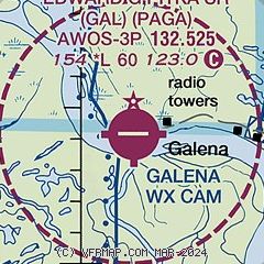
| Sectional chart |
|---|
|
 Download PDF
of official airport diagram from the FAA
| Airport distance calculator |
|---|
|
|
| Sunrise and sunset |
|---|
|
Times for 26-Jul-2026
| | Local
(UTC-8) | | Zulu
(UTC) |
|---|
| Morning civil twilight | | + | | + |
| Sunrise | | 05:10 | | 13:10 |
| Sunset | | 23:58 | | 07:58 |
| Evening civil twilight | | + | | + |
|
| Current date and time |
|---|
| Zulu (UTC) | 27-Jul-2026 00:13:19 |
|---|
| Local (UTC-8) | 26-Jul-2026 16:13:19 |
|---|
|
| METAR |
|---|
| PAGA | 262356Z AUTO 29006KT 10SM OVC060 19/08 A2986 RMK AO2 SLP111 T01890078 10206 20122 58006 TSNO
|
|
| TAF |
|---|
| PAGA | 261725Z 2618/2718 24008KT P6SM BKN050 OVC100 FM270000 29010KT P6SM OVC050 FM270300 32009KT P6SM -SHRA SCT030 OVC050 FM270800 34010KT P6SM SCT050
|
|
| NOTAMs |
|---|
NOTAMs are issued by the DoD/FAA and will open in a separate window not controlled by AirNav.
|
|


