FAA INFORMATION EFFECTIVE 11 JUNE 2026
Location
| FAA Identifier: | RRT |
| Lat/Long: | 48-56-29.3000N 095-20-54.5000W
48-56.488333N 095-20.908333W
48.9414722,-95.3484722
(estimated) |
| Elevation: | 1075.5 ft. / 327.8 m (surveyed) |
| Variation: | 04E (1995) |
| From city: | 2 miles NW of WARROAD, MN |
| Time zone: | UTC -5 (UTC -6 during Standard Time) |
| Zip code: | 56763 |
Airport Operations
| Airport use: | Open to the public |
| Activation date: | 08/1949 |
| Control tower: | no |
| ARTCC: | MINNEAPOLIS CENTER |
| FSS: | PRINCETON FLIGHT SERVICE STATION |
| NOTAMs facility: | RRT (NOTAM-D service available) |
| Attendance: | MON-FRI 0700-1700
FOR SVC NGTS & WKENDS CALL AMGR. |
| Wind indicator: | lighted |
| Segmented circle: | no |
| Lights: | ACTVT OR INCR INTST MALSR RWY 13 & 31; HIRL RWY 13/31 - CTAF. PAPI RWY 13 & 31 OPR CONSLY; HIRL RWY 13/31 PRESET LOW INTST. PCL UNAVBL DURG DALGT HRS. |
| Beacon: | white-green (lighted land airport)
Operates sunset to sunrise. |
| International operations: | customs landing rights airport |
Airport Communications
| CTAF/UNICOM: | 123.05 |
| WX AWOS-3: | 119.925 (218-386-1813) |
| WX AWOS-3PT at ROX (15 nm W): | 118.075 (218-463-1803) |
- APCH/DEP SVC PRVDD BY MINNEAPOLIS ARTCC ON FREQS 134.75/251.1 (ROSEAU RCAG).
Nearby radio navigation aids
| NDB name | | Hdg/Dist | | Freq | | Var | | ID |
|---|
| ROADD | | 314/6.3 | | 360 | | 04E | | SW | ... .-- |
Airport Services
| Fuel available: | 100LL JET-A
100LL:FUEL AVBL H24 SELF SVC VIA CREDIT CARD. |
| Parking: | hangars and tiedowns |
| Airframe service: | NONE |
| Powerplant service: | NONE |
| Bottled oxygen: | NONE |
| Bulk oxygen: | NONE |
Runway Information
Runway 13/31
| Dimensions: | 5400 x 100 ft. / 1646 x 30 m |
| Surface: | asphalt, in good condition |
| Weight bearing capacity: | | Single wheel: | 30.0 | | Double wheel: | 40.0 |
|
| Runway edge lights: | high intensity |
| RUNWAY 13 | | RUNWAY 31 |
| Latitude: | 48-56.759005N | | 48-56.092950N |
| Longitude: | 095-21.252843W | | 095-20.361240W |
| Elevation: | 1072.5 ft. | | 1074.3 ft. |
| Traffic pattern: | left | | left |
| Runway heading: | 135 magnetic, 139 true | | 315 magnetic, 319 true |
| Markings: | precision, in good condition | | precision, in good condition |
| Visual slope indicator: | 4-light PAPI on left (3.00 degrees glide path) | | 4-light PAPI on left (3.00 degrees glide path) |
| Approach lights: | MALSR: 1,400 foot medium intensity approach lighting system with runway alignment indicator lights | | MALSR: 1,400 foot medium intensity approach lighting system with runway alignment indicator lights |
| Runway end identifier lights: | no | | |
| Touchdown point: | yes, no lights | | yes, no lights |
| Instrument approach: | | | ILS/DME |
Runway 4/22
| Dimensions: | 2987 x 150 ft. / 910 x 46 m |
| Surface: | turf, in good condition |
| Runway edge markings: | MKD WITH YELLOW CONES. |
| Operational restrictions: | CLSD WINTER MONTHS. |
| RUNWAY 4 | | RUNWAY 22 |
| Latitude: | 48-56.416117N | | 48-56.783728N |
| Longitude: | 095-21.336712W | | 095-20.842308W |
| Elevation: | 1073.1 ft. | | 1069.9 ft. |
| Traffic pattern: | left | | left |
| Runway heading: | 038 magnetic, 042 true | | 218 magnetic, 222 true |
| Markings: | NSTD, in good condition | | NSTD, in good condition |
| Runway end identifier lights: | | | no |
| Touchdown point: | yes, no lights | | yes, no lights |
Airport Ownership and Management from official FAA records
| Ownership: | Publicly-owned |
| Owner: | CITY OF WARROAD
CITY HALL, PO BOX 50
WARROAD, MN 56763-0050
Phone 218-386-1454 |
| Manager: | MATT RACHUY
PO BOX 50, 36955 COUNTY ROAD 13
WARROAD, MN 56763-0050
Phone 218-386-1691 |
Additional Remarks
| A30A-31 | CALM WIND RWY. |
| - | DEER & BIRDS ON & INVOF ARPT. |
| - | CUST AVBL 1 HR PPR CALL 218-386-1676, CELL 218-689-3880, OTR 218-386-2796. |
| - | GCO AVBL ON FREQ 121.725 (MINNEAPOLIS CENTER AND FLIGHT SERVICES). |
| - | FOR CD IF UNA TO CTC ON FSS FREQ, CTC MINNEAPOLIS ARTCC AT 651-463-5588. |
Instrument Procedures
NOTE: All procedures below are presented as PDF files. If you need a reader for these files, you should download the free Adobe Reader.NOT FOR NAVIGATION. Please procure official charts for flight.
FAA instrument procedures published for use from 11 June 2026 at 0901Z to 09 July 2026 at 0900z.
IAPs - Instrument Approach Procedures |
|---|
| ILS OR LOC RWY 31 **CHANGED** | |
download (238KB) |
| RNAV (GPS) RWY 13 **CHANGED** | |
download (215KB) |
| RNAV (GPS) RWY 31 **CHANGED** | |
download (217KB) |
| NOTE: Special Alternate Minimums apply | |
download (160KB) |
| NOTE: Special Take-Off Minimums/Departure Procedures apply | |
download (406KB) |
Other nearby airports with instrument procedures:
KROX - Roseau Municipal Airport/Rudy Billberg Field (15 nm W)
KBDE - Baudette International Airport (32 nm SE)
KTVF - Thief River Falls Regional Airport (62 nm SW)
KHCO - Hallock Municipal Airport (64 nm W)
D37 - Warren Municipal Airport (70 nm SW)
|
|

Road maps at:
MapQuest
Bing
Google
| Aerial photo |
|---|

|
| Sectional chart |
|---|
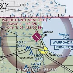
|
| Airport distance calculator |
|---|
|
|
| Sunrise and sunset |
|---|
|
Times for 05-Jul-2026
| | Local
(UTC-5) | | Zulu
(UTC) |
|---|
| Morning civil twilight | | 04:43 | | 09:43 |
| Sunrise | | 05:25 | | 10:25 |
| Sunset | | 21:26 | | 02:26 |
| Evening civil twilight | | 22:08 | | 03:08 |
|
| Current date and time |
|---|
| Zulu (UTC) | 06-Jul-2026 01:05:17 |
|---|
| Local (UTC-5) | 05-Jul-2026 20:05:17 |
|---|
|
| METAR |
|---|
| KRRT | 060055Z AUTO 00000KT 10SM CLR 27/19 A2999 RMK AO2
|
KROX
15nm W | 060055Z AUTO 20005KT 10SM CLR 25/21 A2999 RMK AO2 RAB0039E0049 P0000 T02540209
|
|
| NOTAMs |
|---|
NOTAMs are issued by the DoD/FAA and will open in a separate window not controlled by AirNav.
|
|

