FAA INFORMATION EFFECTIVE 11 JUNE 2026
Location
| FAA Identifier: | D37 |
| Lat/Long: | 48-11-28.2000N 096-42-40.7000W
48-11.470000N 096-42.678333W
48.1911667,-96.7113056
(estimated) |
| Elevation: | 888.2 ft. / 270.7 m (surveyed) |
| Variation: | 05E (2000) |
| From city: | 2 miles E of WARREN, MN |
| Time zone: | UTC -5 (UTC -6 during Standard Time) |
| Zip code: | 56762 |
Airport Operations
| Airport use: | Open to the public |
| Activation date: | 09/1948 |
| Control tower: | no |
| ARTCC: | MINNEAPOLIS CENTER |
| FSS: | PRINCETON FLIGHT SERVICE STATION |
| NOTAMs facility: | PNM (NOTAM-D service available) |
| Attendance: | MAY-OCT SAT-SUN 0800-1700 |
| Wind indicator: | lighted |
| Segmented circle: | no |
| Lights: | SS-SR |
| Beacon: | white-green (lighted land airport)
Operates sunset to sunrise. |
Airport Communications
| CTAF/UNICOM: | 122.8 |
| GRAND FORKS APPROACH: | 118.1 |
| GRAND FORKS DEPARTURE: | 118.1 |
- APCH/DEP SVC PRVDD BY MINNEAPOLIS ARTCC (ZMP) ON FREQ 132.15/269.6 (GRAND FORKS RCAG) WHEN GRAND FORKS (RDR) APCH CTL CLSD.
Nearby radio navigation aids
| VOR radial/distance | | VOR name | | Freq | | Var |
|---|
| TVFr281/22.3 | | THIEF RIVER FALLS VOR/DME | | 114.45 | | 08E |
| GFKr044/23.7 | | GRAND FORKS VOR/DME | | 114.30 | | 09E |
Airport Services
| Parking: | hangars and tiedowns |
Runway Information
Runway 12/30
| Dimensions: | 3199 x 75 ft. / 975 x 23 m |
| Surface: | asphalt, in good condition |
| Weight bearing capacity: | |
| Runway edge lights: | medium intensity |
| RUNWAY 12 | | RUNWAY 30 |
| Latitude: | 48-11.624120N | | 48-11.282633N |
| Longitude: | 096-42.938475W | | 096-42.340022W |
| Elevation: | 887.2 ft. | | 885.4 ft. |
| Traffic pattern: | left | | left |
| Runway heading: | 125 magnetic, 130 true | | 305 magnetic, 310 true |
| Displaced threshold: | 190 ft. | | no |
| Declared distances: | TORA:3199 TODA:3199 ASDA:3199 LDA:3009 | | TORA:3199 TODA:3199 ASDA:3199 LDA:3199 |
| Markings: | nonprecision, in good condition | | nonprecision, in good condition |
| Touchdown point: | yes, no lights | | yes, no lights |
| Obstructions: | 18 ft. road, 507 ft. from runway, 266 ft. left of centerline, 17:1 slope to clear | | none |
Runway 4/22
| Dimensions: | 2578 x 200 ft. / 786 x 61 m |
| Surface: | turf, in good condition |
| Runway edge markings: | MKD WITH YELLOW CONES. |
| Operational restrictions: | MARKED WITH YELLOW CONES. NOT PLOWED WINTER MONTHS. |
| RUNWAY 4 | | RUNWAY 22 |
| Latitude: | 48-11.348302N | | 48-11.632635N |
| Longitude: | 096-42.962122W | | 096-42.491685W |
| Elevation: | 886.2 ft. | | 884.9 ft. |
| Traffic pattern: | left | | left |
| Runway heading: | 043 magnetic, 048 true | | 223 magnetic, 228 true |
| Markings: | NSTD, in fair condition | | NSTD, in fair condition |
| Touchdown point: | yes, no lights | | yes, no lights |
Airport Ownership and Management from official FAA records
| Ownership: | Publicly-owned |
| Owner: | CITY OF WARREN
120 E BRIDGE AVE
WARREN, MN 56762
Phone 218-745-5343 |
| Manager: | AARON PETERSON
120 E. BRIDGE AVE.
WARREN, MN 56762
Phone (218) 201-0652
USE TEXT MSGG WHEN CTCG ARPT MGR. |
Additional Remarks
| A30A-30 | CALM WND RWY. |
| - | DEER & GEESE ON & INVOF ARPT. |
| - | TOWER 4 'WNW', 1248 FT MSL (400 FT AGL). |
| - | FOR CD CTC MINNEAPOLIS ARTCC AT 651-463-5588. |
Instrument Procedures
NOTE: All procedures below are presented as PDF files. If you need a reader for these files, you should download the free Adobe Reader.NOT FOR NAVIGATION. Please procure official charts for flight.
FAA instrument procedures published for use from 11 June 2026 at 0901Z to 09 July 2026 at 0900z.
IAPs - Instrument Approach Procedures |
|---|
| RNAV (GPS) RWY 30 | |
download (185KB) |
| NOTE: Special Take-Off Minimums/Departure Procedures apply | |
download (223KB) |
Other nearby airports with instrument procedures:
KCKN - Crookston Municipal Airport - Kirkwood Field (21 nm S)
KTVF - Thief River Falls Regional Airport (22 nm E)
KGFK - Grand Forks International Airport (24 nm SW)
KGAF - Hutson Field Airport (29 nm NW)
KRDR - Grand Forks Air Force Base (31 nm SW)
|
|

Road maps at:
MapQuest
Bing
Google
| Aerial photo |
|---|
WARNING: Photo may not be current or correct
 Photo taken 10-Jun-2015
looking northwest.
Photo taken 10-Jun-2015
looking northwest.
Do you have a better or more recent aerial photo of Warren Municipal Airport that you would like to share? If so, please send us your photo.
|
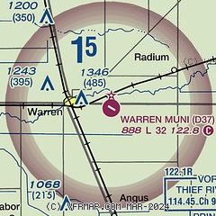
| Sectional chart |
|---|
|
| Airport distance calculator |
|---|
|
|
| Sunrise and sunset |
|---|
|
Times for 11-Jun-2026
| | Local
(UTC-5) | | Zulu
(UTC) |
|---|
| Morning civil twilight | | 04:46 | | 09:46 |
| Sunrise | | 05:27 | | 10:27 |
| Sunset | | 21:26 | | 02:26 |
| Evening civil twilight | | 22:07 | | 03:07 |
|
| Current date and time |
|---|
| Zulu (UTC) | 11-Jun-2026 11:03:15 |
|---|
| Local (UTC-5) | 11-Jun-2026 06:03:15 |
|---|
|
| METAR |
|---|
KCKN
21nm S | 111055Z AUTO 22010KT 10SM CLR 13/11 A2955 RMK AO2
|
KTVF
23nm E | 111056Z AUTO 22012KT 10SM CLR 13/09 A2953 RMK AO2 SLP998 T01330094
|
KGFK
24nm SW | 111053Z 22011KT 10SM FEW100 SCT200 14/09 A2950 RMK AO2 SLP987 T01390089 $
|
KGAF
29nm NW | 111055Z AUTO 22009KT 10SM FEW044 FEW049 13/11 A2948 RMK AO2 PWINO
|
KRDR
31nm SW | 111055Z 26016G20KT 10SM CLR 14/09 A2948 RMK AO2A SLP986 T01400086 $
|
KHCO
35nm N | 111055Z AUTO 20008KT 7SM -RA SCT029 SCT050 OVC080 14/13 A2946 RMK AO2
|
|
| TAF |
|---|
KTVF
23nm E | 110520Z 1106/1206 23011KT P6SM SCT100 FM111500 24015G22KT P6SM BKN035 FM111900 28015G24KT P6SM BKN035 PROB30 1119/1123 6SM -SHRA BKN025 FM120000 27011KT P6SM SCT060
|
KGFK
24nm SW | 110520Z 1106/1206 24009KT P6SM SCT100 FM111300 26017G25KT P6SM BKN027 FM111800 28018G26KT P6SM BKN035 PROB30 1119/1123 6SM -SHRA BKN025 FM120000 29014G22KT P6SM SCT060
|
|
| NOTAMs |
|---|
NOTAMs are issued by the DoD/FAA and will open in a separate window not controlled by AirNav.
|
|

