FAA INFORMATION EFFECTIVE 19 FEBRUARY 2026
Location
| FAA Identifier: | GAF |
| Lat/Long: | 48-24-16.9760N 097-22-15.4440W
48-24.282933N 097-22.257400W
48.4047156,-97.3709567
(estimated) |
| Elevation: | 824.5 ft. / 251.3 m (surveyed) |
| Variation: | 06E (2000) |
| From city: | 2 miles ESE of GRAFTON, ND |
| Time zone: | UTC -6 (UTC -5 during Daylight Saving Time) |
| Zip code: | 58237 |
Airport Operations
| Airport use: | Open to the public |
| Activation date: | 10/1947 |
| Control tower: | no |
| ARTCC: | MINNEAPOLIS CENTER |
| FSS: | GRAND FORKS FLIGHT SERVICE STATION |
| NOTAMs facility: | GFK (NOTAM-D service available) |
| Attendance: | MON-FRI DAYLIGHT HOURS, ALL SAT-SUN ON CALL
FOR SVC AFT HRS CALL 701-331-4220. |
| Wind indicator: | lighted |
| Segmented circle: | no |
| Lights: | PAPI RWY 17 & 35, MIRL RWY 17/35 PRESET ON LOW INTST DUSK-2300; TO INCR INTST AFT 2300 ACTVT - CTAF. |
| Beacon: | white-green (lighted land airport)
Operates sunset to sunrise. |
Airport Communications
| CTAF/UNICOM: | 122.8 |
| WX AWOS-3: | 118.625 (701-352-0581) |
| GRAND FORKS APPROACH: | 118.1 |
| GRAND FORKS DEPARTURE: | 118.1 |
- APCH/DEP SVC PRVDD BY MINNEAPOLIS ARTCC (ZMP) ON FREQ 132.15/269.6 (GRAND FORKS RCAG) WHEN GRAND FORKS (RDR) APCH CTL CLSD.
Nearby radio navigation aids
| VOR radial/distance | | VOR name | | Freq | | Var |
|---|
| GFKr336/28.0 | | GRAND FORKS VOR/DME | | 114.30 | | 09E |
Airport Services
| Fuel available: | 100LL JET-A
100LL:24-HR SELF SVC FUEL AVBL WITH CREDIT CARD ONLY. |
| Parking: | hangars and tiedowns |
| Airframe service: | NONE |
| Powerplant service: | NONE |
| Bottled oxygen: | NONE |
| Bulk oxygen: | NONE |
Runway Information
Runway 17/35
| Dimensions: | 3898 x 74 ft. / 1188 x 23 m |
| Surface: | asphalt, in good condition |
| Weight bearing capacity: | |
| Runway edge lights: | medium intensity |
| RUNWAY 17 | | RUNWAY 35 |
| Latitude: | 48-24.646602N | | 48-24.005793N |
| Longitude: | 097-21.952863W | | 097-21.953497W |
| Elevation: | 822.2 ft. | | 821.9 ft. |
| Traffic pattern: | left | | left |
| Runway heading: | 174 magnetic, 180 true | | 354 magnetic, 360 true |
| Markings: | nonprecision, in fair condition | | nonprecision, in fair condition |
| Visual slope indicator: | 2-light PAPI on left (3.00 degrees glide path) | | 2-light PAPI on left (3.00 degrees glide path) |
| Touchdown point: | yes, no lights | | yes, no lights |
Runway 8/26
| Dimensions: | 4074 x 115 ft. / 1242 x 35 m |
| Surface: | turf, in good condition
TURF SOFT WHEN WET. |
| Runway edge markings: | RWY 08/26 - MKD WITH WHITE DALGT END MKRS. |
| RUNWAY 8 | | RUNWAY 26 |
| Latitude: | 48-24.243753N | | 48-24.239275N |
| Longitude: | 097-23.051475W | | 097-22.045175W |
| Elevation: | 820.6 ft. | | 820.8 ft. |
| Traffic pattern: | left | | left |
| Runway heading: | 084 magnetic, 090 true | | 264 magnetic, 270 true |
| Touchdown point: | yes, no lights | | yes, no lights |
Airport Ownership and Management from official FAA records
| Ownership: | Publicly-owned |
| Owner: | GRAFTON ARPT AUTH
PO BOX 578
GRAFTON, ND 58237
Phone 701-331-4220
CHAIRMAN ARPT AUTH RANDY SCHUSTER. |
| Manager: | BRIAN EROVICK
15182 HWY 17
GRAFTON, ND 58237
Phone 701-331-4220 |
Additional Remarks
| - | BE ALERT: 3 FT DITCH BTN EAST END 8/26 & 17/35, USE DSGND TWYS. |
| - | FOR CD CTC MINNEAPOLIS ARTCC AT 651-463-5588. |
| - | LARGE BIRDS AND DEER ON OR INVOF ARPT. |
| - | HVY AERIAL SPRAY ACTIVITY MAY-OCT. |
| - | CFM WINTER CONDS & SNOW REMOVAL WITH AMGR CALL 701-331-4220/701-360-1365. |
| - | NMRS TSNT FLT TRNG ACTIVITIES. |
| - | RWY 08/26 CLSD WINTER MONTHS DUE TO LACK OF SNOW REMOVAL. |
| - | RWY 08 HAS +3' DITCH 213' FM THRSHOLD |
Instrument Procedures
NOTE: All procedures below are presented as PDF files. If you need a reader for these files, you should download the free Adobe Reader.NOT FOR NAVIGATION. Please procure official charts for flight.
FAA instrument procedures published for use from 19 February 2026 at 0901Z to 19 March 2026 at 0900Z.
IAPs - Instrument Approach Procedures |
|---|
| RNAV (GPS) RWY 17 | |
download (254KB) |
| RNAV (GPS) RWY 35 | |
download (239KB) |
| NOTE: Special Take-Off Minimums/Departure Procedures apply | |
download (396KB) |
Other nearby airports with instrument procedures:
2C8 - Cavalier Municipal Airport (25 nm NW)
KRDR - Grand Forks Air Force Base (27 nm S)
KHCO - Hallock Municipal Airport (27 nm NE)
KGFK - Grand Forks International Airport (29 nm S)
D37 - Warren Municipal Airport (29 nm SE)
|
|

Road maps at:
MapQuest
Bing
Google
| Aerial photo |
|---|
WARNING: Photo may not be current or correct

Do you have a better or more recent aerial photo of Hutson Field Airport that you would like to share? If so, please send us your photo.
|
| Sectional chart |
|---|
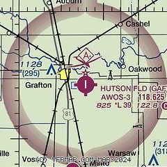
|
| Airport distance calculator |
|---|
|
|
| Sunrise and sunset |
|---|
|
Times for 23-Feb-2026
| | Local
(UTC-6) | | Zulu
(UTC) |
|---|
| Morning civil twilight | | 06:52 | | 12:52 |
| Sunrise | | 07:23 | | 13:23 |
| Sunset | | 18:03 | | 00:03 |
| Evening civil twilight | | 18:34 | | 00:34 |
|
| Current date and time |
|---|
| Zulu (UTC) | 23-Feb-2026 07:48:21 |
|---|
| Local (UTC-6) | 23-Feb-2026 01:48:21 |
|---|
|
| METAR |
|---|
| KGAF | 230735Z AUTO 32005KT 10SM CLR M24/M26 A3080 RMK AO2 PWINO
|
|
| TAF |
|---|
KGFK
28nm S | 230520Z 2306/2406 32007KT P6SM SKC FM230800 VRB03KT P6SM BKN150 FM231500 16012KT P6SM BKN090 FM231800 17018G26KT 6SM BLSN SCT025 BKN150
|
|
| NOTAMs |
|---|
NOTAMs are issued by the DoD/FAA and will open in a separate window not controlled by AirNav.
|
|

