FAA INFORMATION EFFECTIVE 09 JULY 2026
Location
| FAA Identifier: | Y37 |
| Lat/Long: | 48-23-38.7000N 097-46-50.7720W
48-23.645000N 097-46.846200W
48.3940833,-97.7807700
(estimated) |
| Elevation: | 1104.1 ft. / 336.5 m (surveyed) |
| Variation: | 03E (2030) |
| From city: | 1 mile W of PARK RIVER, ND |
| Time zone: | UTC -5 (UTC -6 during Standard Time) |
| Zip code: | 58270 |
Airport Operations
| Airport use: | Open to the public |
| Activation date: | 12/1959 |
| Control tower: | no |
| ARTCC: | MINNEAPOLIS CENTER |
| FSS: | GRAND FORKS FLIGHT SERVICE STATION |
| NOTAMs facility: | GFK (NOTAM-D service available) |
| Attendance: | ON CALL
FOR SERVICE AFTER HOURS CALL 701-331-0818. |
| Wind indicator: | lighted |
| Segmented circle: | yes |
| Lights: | ACTVT MIRL RWY 13/31 SS-SR - CTAF. PAPI RWYS 13 & 31 OPR CONSLY. |
| Beacon: | white-green (lighted land airport)
Operates sunset to sunrise. |
Airport Communications
| CTAF/UNICOM: | 122.8 |
| GRAND FORKS APPROACH: | 118.1 |
| GRAND FORKS DEPARTURE: | 118.1 |
| WX AWOS-3 at GAF (16 nm E): | 118.625 (701-352-0581) |
- APCH/DEP SVC PRVDD BY MINNEAPOLIS ARTCC (ZMP) ON FREQS 132.15/269.6 (GRAND FORKS RCAG) WHEN GRAND FORKS APCH CLSD.
Nearby radio navigation aids
| VOR radial/distance | | VOR name | | Freq | | Var |
|---|
| GFKr309/35.5 | | GRAND FORKS VOR/DME | | 114.30 | | 09E |
Airport Services
| Fuel available: | 100LL JET-A |
| Parking: | hangars and tiedowns |
| Airframe service: | NONE |
| Powerplant service: | NONE |
| Bottled oxygen: | NONE |
| Bulk oxygen: | NONE |
Runway Information
Runway 13/31
| Dimensions: | 3100 x 60 ft. / 945 x 18 m |
| Surface: | asphalt, in good condition |
| Weight bearing capacity: | |
| Runway edge lights: | medium intensity |
| RUNWAY 13 | | RUNWAY 31 |
| Latitude: | 48-23.787177N | | 48-23.434075N |
| Longitude: | 097-47.123903W | | 097-46.571620W |
| Elevation: | 1104.1 ft. | | 1086.6 ft. |
| Traffic pattern: | left | | left |
| Runway heading: | 131 magnetic, 134 true | | 311 magnetic, 314 true |
| Markings: | nonprecision, in good condition | | nonprecision, in good condition |
| Visual slope indicator: | 2-light PAPI on left (3.00 degrees glide path) | | 2-light PAPI on left (3.00 degrees glide path) |
| Touchdown point: | yes, no lights | | yes, no lights |
| Obstructions: | 103 ft. trees, 2100 ft. from runway, 100 ft. both sides of centerline, 18:1 slope to clear | | none |
Runway 4/22
| Dimensions: | 2499 x 100 ft. / 762 x 30 m |
| Surface: | turf, in good condition |
| RUNWAY 4 | | RUNWAY 22 |
| Latitude: | 48-23.536040N | | 48-23.839223N |
| Longitude: | 097-47.052513W | | 097-46.636055W |
| Elevation: | 1103.1 ft. | | 1087.0 ft. |
| Traffic pattern: | left | | left |
| Runway heading: | 039 magnetic, 042 true | | 219 magnetic, 222 true |
| Touchdown point: | yes, no lights | | yes, no lights |
Airport Ownership and Management from official FAA records
| Ownership: | Publicly-owned |
| Owner: | PARK RIVER AIRPORT AUTH
P.O. BOX 611
PARK RIVER, ND 58270
Phone 701-331-0818 |
| Manager: | JAYSE WHARAM
P.O. BOX 611
PARK RIVER, ND 58270
Phone 701-331-0818 |
Additional Remarks
| A52-22 | ALSO +23 FT PLINE 580 FT FROM THR ON CNTRLN APCH RATIO 25:1. |
| - | DEER & BIRDS ON & INVOF ARPT. |
| - | RWY 04/22 CLSD WINTER MONTHS DUE TO LACK OF SNOW REMOVAL. |
| - | CFM WINTER CONDS AFT MAJOR STORM CALL 701-331-0818. |
| - | FOR CD CTC MINNEAPOLIS ARTCC AT 651-463-5588. |
Instrument Procedures
NOTE: All procedures below are presented as PDF files. If you need a reader for these files, you should download the free Adobe Reader.NOT FOR NAVIGATION. Please procure official charts for flight.
FAA instrument procedures published for use from 09 July 2026 at 0901Z to 06 August 2026 at 0900Z.
IAPs - Instrument Approach Procedures |
|---|
| RNAV (GPS) RWY 31 | |
download (191KB) |
| NOTE: Special Take-Off Minimums/Departure Procedures apply | |
download (437KB) |
Other nearby airports with instrument procedures:
KGAF - Hutson Field Airport (16 nm E)
2C8 - Cavalier Municipal Airport (24 nm N)
KRDR - Grand Forks Air Force Base (30 nm SE)
5L0 - Lakota Municipal Airport (31 nm SW)
D55 - Robertson Field Airport (33 nm NW)
|
|

Road maps at:
MapQuest
Bing
Google
| Aerial photo |
|---|
WARNING: Photo may not be current or correct

Do you have a better or more recent aerial photo of Park River Airport-W C Skjerven Field that you would like to share? If so, please send us your photo.
|
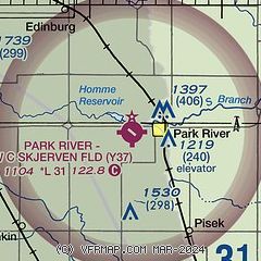
| Sectional chart |
|---|
|
| Airport distance calculator |
|---|
|
|
| Sunrise and sunset |
|---|
|
Times for 19-Jul-2026
| | Local
(UTC-5) | | Zulu
(UTC) |
|---|
| Morning civil twilight | | 05:12 | | 10:12 |
| Sunrise | | 05:51 | | 10:51 |
| Sunset | | 21:24 | | 02:24 |
| Evening civil twilight | | 22:03 | | 03:03 |
|
| Current date and time |
|---|
| Zulu (UTC) | 20-Jul-2026 00:31:30 |
|---|
| Local (UTC-5) | 19-Jul-2026 19:31:30 |
|---|
|
| METAR |
|---|
KGAF
16nm E | 200015Z AUTO 17010KT 9SM CLR 30/21 A2970 RMK AO2 PWINO
|
K2C8
24nm N | 200015Z AUTO 18010G16KT 8SM CLR 31/24 A2967 RMK AO2
|
KRDR
30nm SE | 192355Z AUTO 21016G22KT 10SM CLR 32/20 A2969 RMK AO2 LTG DSNT NE SLP053 T03220198 10336 20294 57020 $
|
KD55
32nm NW | 200015Z AUTO 21009KT 10SM CLR 29/26 A2971 RMK AO2
|
|
| TAF |
|---|
KGFK
36nm SE | 191736Z 1918/2018 20015G21KT P6SM FEW080 SCT150 FM200100 20014KT P6SM BKN080 PROB30 2001/2005 3SM TSRA BKN060CB FM200600 26009KT P6SM BKN070 FM201600 29020G30KT P6SM SCT250
|
|
| NOTAMs |
|---|
NOTAMs are issued by the DoD/FAA and will open in a separate window not controlled by AirNav.
|
|

