FAA INFORMATION EFFECTIVE 14 MAY 2026
Location
| FAA Identifier: | D55 |
| Lat/Long: | 48-45-11.2703N 098-23-37.5690W
48-45.187838N 098-23.626150W
48.7531306,-98.3937692
(estimated) |
| Elevation: | 1608.4 ft. / 490.2 m (surveyed) |
| Variation: | 07E (1985) |
| From city: | 1 mile WSW of LANGDON, ND |
| Time zone: | UTC -5 (UTC -6 during Standard Time) |
| Zip code: | 58249 |
Airport Operations
| Airport use: | Open to the public |
| Activation date: | 03/1938 |
| Control tower: | no |
| ARTCC: | MINNEAPOLIS CENTER |
| FSS: | GRAND FORKS FLIGHT SERVICE STATION |
| NOTAMs facility: | GFK (NOTAM-D service available) |
| Attendance: | ON CALL
FOR SVCS AFT HRS CTC AMGR 701-370-9710. |
| Wind indicator: | lighted |
| Segmented circle: | no |
| Lights: | ACTVT PAPI RWY 14 & 32; MIRL RWY 14/32 - CTAF. |
| Beacon: | white-green (lighted land airport)
Operates sunset to sunrise. |
Airport Communications
| CTAF/UNICOM: | 122.8 |
| WX AWOS-3: | 118.225 (701-256-2121) |
- APCH/DEP SVC PRVDD BY MINNEAPOLIS ARTCC ON FREQS 132.15/269.6 ( GRAND FORKS RCAG).
Airport Services
| Fuel available: | 100LL
100LL:SELF SVC FUEL AVBL 24 HR WITH CREDIT CARD. |
| Parking: | hangars and tiedowns |
| Airframe service: | NONE |
| Powerplant service: | NONE |
| Bottled oxygen: | NONE |
| Bulk oxygen: | NONE |
Runway Information
Runway 14/32
| Dimensions: | 3600 x 60 ft. / 1097 x 18 m |
| Surface: | asphalt, in good condition |
| Weight bearing capacity: | |
| Runway edge lights: | medium intensity |
| RUNWAY 14 | | RUNWAY 32 |
| Latitude: | 48-45.376103N | | 48-44.924443N |
| Longitude: | 098-23.962535W | | 098-23.383747W |
| Elevation: | 1602.9 ft. | | 1608.4 ft. |
| Traffic pattern: | left | | left |
| Runway heading: | 132 magnetic, 139 true | | 312 magnetic, 319 true |
| Markings: | nonprecision, in good condition | | nonprecision, in good condition |
| Visual slope indicator: | 2-light PAPI on left (3.00 degrees glide path) | | 2-light PAPI on left (3.00 degrees glide path) |
| Touchdown point: | yes, no lights | | yes, no lights |
Runway 8/26
| Dimensions: | 1930 x 100 ft. / 588 x 30 m |
| Surface: | turf, in good condition |
| RUNWAY 8 | | RUNWAY 26 |
| Latitude: | 48-45.257667N | | 48-45.257923N |
| Longitude: | 098-23.778500W | | 098-23.298500W |
| Elevation: | 1600.5 ft. | | 1601.0 ft. |
| Traffic pattern: | left | | left |
| Runway heading: | 082 magnetic, 089 true | | 262 magnetic, 269 true |
| Markings: | none | | none |
| Touchdown point: | yes, no lights | | yes, no lights |
| Obstructions: | none | | 14 ft. road, 265 ft. from runway, 18:1 slope to clear
+334 FT TWR 6550 FT FM THLD, 230 FT R OF EXTDD CNTRLN. |
Airport Ownership and Management from official FAA records
| Ownership: | Publicly-owned |
| Owner: | LANGDON ARPT AUTHORITY
1310 12TH ST
LANGDON, ND 58249
Phone 701-370-2076
JOHN BOE, CHAIRMAN OF ARPT AUTH, ADDNL PHONE 701-370-2076. |
| Manager: | RYAN HOWATT
1228 15TH AVE
LANGDON, ND 58249
Phone (701) 370-9710 |
Additional Remarks
| - | RY 08/26 CLOSED WINTERS DUE TO LACK OF SNOW REMOVAL. |
| - | LARGE BIRDS AND DEER ON & INVOF ARPT APR-NOV. |
| - | CFM WINTER CONDS/SNOW REMOVAL WITH AMGR 701-370-9710. |
| - | NOISE SENSITIVE AREA NW QUADRANT OF FIELD; AVOID OVERFLIGHT. |
| - | FOR CD CTC MINNEAPOLIS ARTCC AT 651-463-5588. |
| - | COLD TEMPERATURE AIRPORT. ALTITUDE CORRECTION REQUIRED AT OR BELOW -35C. |
Instrument Procedures
NOTE: All procedures below are presented as PDF files. If you need a reader for these files, you should download the free Adobe Reader.NOT FOR NAVIGATION. Please procure official charts for flight.
FAA instrument procedures published for use from 14 May 2026 at 0901Z to 11 June 2026 at 0900Z.
IAPs - Instrument Approach Procedures |
|---|
| RNAV (GPS) RWY 14 | |
download (201KB) |
| RNAV (GPS) RWY 32 | |
download (282KB) |
| NOTE: Special Alternate Minimums apply | |
download (175KB) |
| NOTE: Special Take-Off Minimums/Departure Procedures apply | |
download (405KB) |
Other nearby airports with instrument procedures:
96D - Walhalla Municipal Airport (22 nm NE)
2C8 - Cavalier Municipal Airport (30 nm E)
Y37 - Park River Airport-W C Skjerven Field (33 nm SE)
9D7 - Cando Municipal Airport (37 nm SW)
KDVL - Devils Lake Regional Airport (43 nm SW)
|
|

Road maps at:
MapQuest
Bing
Google
| Aerial photo |
|---|
WARNING: Photo may not be current or correct

Do you have a better or more recent aerial photo of Robertson Field Airport that you would like to share? If so, please send us your photo.
|
| Sectional chart |
|---|
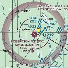
|
| Airport distance calculator |
|---|
|
|
| Sunrise and sunset |
|---|
|
Times for 26-May-2026
| | Local
(UTC-5) | | Zulu
(UTC) |
|---|
| Morning civil twilight | | 05:01 | | 10:01 |
| Sunrise | | 05:41 | | 10:41 |
| Sunset | | 21:21 | | 02:21 |
| Evening civil twilight | | 22:00 | | 03:00 |
|
| Current date and time |
|---|
| Zulu (UTC) | 27-May-2026 00:56:07 |
|---|
| Local (UTC-5) | 26-May-2026 19:56:07 |
|---|
|
| METAR |
|---|
| KD55 | 270035Z AUTO 09013G19KT 10SM CLR 29/00 A2992 RMK AO2
|
|
| TAF |
|---|
KDVL
43nm SW | 261737Z 2618/2718 11018G21KT P6SM SKC FM270100 08015KT P6SM BKN070 PROB30 2704/2709 6SM -TSRA BKN050CB FM271500 10015G21KT P6SM SCT250
|
|
| NOTAMs |
|---|
NOTAMs are issued by the DoD/FAA and will open in a separate window not controlled by AirNav.
|
|

