FAA INFORMATION EFFECTIVE 20 MARCH 2025
Location
| FAA Identifier: | TNP |
| Lat/Long: | 34-07-53.7000N 115-56-44.9000W
34-07.895000N 115-56.748333W
34.1315833,-115.9458056
(estimated) |
| Elevation: | 1888 ft. / 575.5 m (surveyed) |
| Variation: | 12E (2015) |
| From city: | 6 miles E of TWENTYNINE PALMS, CA |
| Time zone: | UTC -7 (UTC -8 during Standard Time) |
| Zip code: | 92277 |
Airport Operations
| Airport use: | Open to the public |
| Activation date: | 02/1959 |
| Control tower: | no |
| ARTCC: | LOS ANGELES CENTER |
| FSS: | RIVERSIDE FLIGHT SERVICE STATION |
| NOTAMs facility: | RAL (NOTAM-D service available) |
| Attendance: | UNATNDD |
| Wind indicator: | lighted |
| Segmented circle: | yes |
| Lights: | ACTVT MIRL RY 08/26 AND 17/35; REIL RY 08 AND RY 26 - CTAF. |
| Beacon: | white-green (lighted land airport)
Operates sunset to sunrise. |
Airport Communications
| CTAF/UNICOM: | 122.8 |
| WX ASOS at NXP (15 nm NW): | 309.75 (760-830-8146) |
- AUTOMATED UNICOM.
- APCH/DEP CTL SVC PRVDD BY LOS ANGELES ARTCC (ZLA) ON FREQS 128.15/285.6 (TWENTYNINE PALMS RCAG).
Nearby radio navigation aids
| VOR radial/distance | | VOR name | | Freq | | Var |
|---|
| TNPr263/8.8 | | TWENTYNINE PALMS VORTAC | | 114.20 | | 15E |
| PSPr044/28.7 | | PALM SPRINGS VORTAC | | 115.50 | | 13E |
| TRMr006/32.0 | | THERMAL VORTAC | | 116.20 | | 13E |
Airport Services
| Fuel available: | 100LL
100LL:100LL AVBL 24 HRS. |
| Parking: | tiedowns |
| Airframe service: | MINOR |
| Powerplant service: | MINOR |
| Bottled oxygen: | NONE |
| Bulk oxygen: | NONE |
Runway Information
Runway 8/26
| Dimensions: | 5531 x 75 ft. / 1686 x 23 m |
| Surface: | asphalt, in fair condition |
| Runway edge lights: | medium intensity |
| RUNWAY 8 | | RUNWAY 26 |
| Latitude: | 34-08.060812N | | 34-08.066303N |
| Longitude: | 115-57.206290W | | 115-56.109893W |
| Elevation: | 1876.6 ft. | | 1786.4 ft. |
| Traffic pattern: | left | | left |
| Runway heading: | 078 magnetic, 090 true | | 258 magnetic, 270 true |
| Markings: | basic, in good condition | | nonprecision, in good condition |
| Visual slope indicator: | 2-light PAPI on left (3.00 degrees glide path) | | 2-light PAPI on left (3.00 degrees glide path) |
| Runway end identifier lights: | yes | | yes |
| Touchdown point: | yes, no lights | | yes, no lights |
| Obstructions: | 120 ft. pline, 4100 ft. from runway, 32:1 slope to clear | | none |
Runway 17/35
| Dimensions: | 3797 x 50 ft. / 1157 x 15 m |
| Surface: | asphalt, in fair condition |
| Runway edge lights: | medium intensity |
| RUNWAY 17 | | RUNWAY 35 |
| Latitude: | 34-07.964298N | | 34-07.338302N |
| Longitude: | 115-56.880843W | | 115-56.882778W |
| Elevation: | 1853.5 ft. | | 1888.0 ft. |
| Traffic pattern: | left | | left |
| Runway heading: | 168 magnetic, 180 true | | 348 magnetic, 000 true |
| Markings: | basic, in good condition | | basic, in good condition |
| Runway end identifier lights: | no | | no |
| Touchdown point: | yes, no lights | | yes, no lights |
| Obstructions: | 30 ft. pline, 1400 ft. from runway, 40:1 slope to clear
PLINES | | 200 ft. hill, 3300 ft. from runway, 15:1 slope to clear
+2 FT TERRAIN AT 200 FT FROM THLD. |
Airport Ownership and Management from official FAA records
| Ownership: | Publicly-owned |
| Owner: | COUNTY OF SAN BERNARDINO
777 EAST RIALTO AVENUE
SAN BERNARDINO, CA 92415
Phone 909-387-8810 |
| Manager: | MAUREEN A. SNELGROVE
777 E. RIALTO AVE.
SAN BERNARDINO, CA 92415
Phone 909-387-8810 |
Additional Remarks
| - | TWY LGTS ON TWY CONNECTING RWY 08/26 & RWY 17/35; PLUS BLUE REFLECTORS ON PARALLEL TWY SERVING RWY 17/35. |
| - | BE ALERT FOR AEROBATIC ACTIVITY SOUTH OF RY 17/35. |
| - | FOR CD IF UNA TO CTC ON FSS FREQ, CTC LOS ANGELES ARTCC AT 661-575-2079. |
Instrument Procedures
NOTE: All procedures below are presented as PDF files. If you need a reader for these files, you should download the free Adobe Reader.NOT FOR NAVIGATION. Please procure official charts for flight.
FAA instrument procedures published for use from 20 March 2025 at 0901Z to 17 April 2025 at 0900z.
IAPs - Instrument Approach Procedures |
|---|
| RNAV (GPS) RWY 26 **CHANGED** | |
download (259KB) |
| VOR RWY 26 **CHANGED** | |
download (235KB) |
| NOTE: Special Take-Off Minimums/Departure Procedures apply | |
download (132KB) |
Other nearby airports with instrument procedures:
KUDD - Bermuda Dunes Airport (28 nm SW)
KTRM - Jacqueline Cochran Regional Airport (32 nm S)
KPSP - Palm Springs International Airport (33 nm SW)
L35 - Big Bear City Airport (46 nm W)
L08 - Borrego Valley Airport (56 nm S)
|
|

Road maps at:
MapQuest
Bing
Google
| Aerial photo |
|---|
WARNING: Photo may not be current or correct
 Photo taken 22-Jul-2007
Do you have a better or more recent aerial photo of Twentynine Palms Airport that you would like to share? If so, please send us your photo.
|
| Sectional chart |
|---|
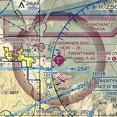
|
| Airport distance calculator |
|---|
|
|
| Sunrise and sunset |
|---|
|
Times for 08-Apr-2025
| | Local
(UTC-7) | | Zulu
(UTC) |
|---|
| Morning civil twilight | | 05:57 | | 12:57 |
| Sunrise | | 06:23 | | 13:23 |
| Sunset | | 19:09 | | 02:09 |
| Evening civil twilight | | 19:34 | | 02:34 |
|
| Current date and time |
|---|
| Zulu (UTC) | 08-Apr-2025 14:56:44 |
|---|
| Local (UTC-7) | 08-Apr-2025 07:56:44 |
|---|
|
| METAR |
|---|
KNXP
14nm NW | 081354Z AUTO 27010KT 10SM CLR 16/M01 A3009 RMK AO2 SLP160 T01561006
|
|
| TAF |
|---|
KNXP
14nm NW | 0803/0903 23012G22KT 9999 SKC 520109 521002 QNH3003INS FM080600 28009KT 9999 SKC 500000 QNH3006INS FM080800 29006KT 9999 SKC QNH3007INS BECMG 0816/0818 10006KT QNH3002INS BECMG 0820/0822 16009KT QNH2994INS FM090100 19011KT 9999 SKC QNH2995INS TX31/0821Z TN12/0814Z
|
|
| NOTAMs |
|---|
NOTAMs are issued by the DoD/FAA and will open in a separate window not controlled by AirNav.
|
|


