FAA INFORMATION EFFECTIVE 09 JULY 2026
Location
| FAA Identifier: | W27 |
| Lat/Long: | 45-53-57.0570N 122-44-15.0375W
45-53.950950N 122-44.250625W
45.8991825,-122.7375104
(estimated) |
| Elevation: | 29 ft. / 9 m (estimated) |
| Variation: | 20E (1985) |
| From city: | 1 mile SE of WOODLAND, WA |
| Time zone: | UTC -7 (UTC -8 during Standard Time) |
| Zip code: | 98674 |
Airport Operations
| Airport use: | Open to the public |
| Activation date: | 07/1969 |
| Control tower: | no |
| ARTCC: | SEATTLE CENTER |
| FSS: | SEATTLE FLIGHT SERVICE STATION |
| NOTAMs facility: | SEA (NOTAM-D service available) |
| Attendance: | UNATNDD |
| Wind indicator: | yes |
| Segmented circle: | no |
| Lights: | SS-SR |
Airport Communications
| CTAF: | 122.9 |
| WX ASOS at SPB (9 nm SW): | 135.875 (503-543-6401) |
| WX AWOS-3PT at KLS (15 nm NW): | 135.075 (360-577-1964) |
| WX ASOS at VUO (17 nm S): | 135.125 (360-696-1280) |
| WX ASOS at PDX (20 nm S): | PHONE 458-212-2405 |
Nearby radio navigation aids
| VOR radial/distance | | VOR name | | Freq | | Var |
|---|
| BTGr305/10.9 | | BATTLE GROUND VORTAC | | 116.60 | | 21E |
| UBGr356/34.3 | | NEWBERG VOR/DME | | 117.40 | | 21E |
| NDB name | | Hdg/Dist | | Freq | | Var | | ID |
|---|
| BANKS | | 023/20.7 | | 356 | | 16E | | PND | .--. -. -.. |
Airport Services
| Parking: | tiedowns |
| Airframe service: | NONE |
| Powerplant service: | NONE |
| Bottled oxygen: | NONE |
| Bulk oxygen: | NONE |
Runway Information
Runway 14/32
| Dimensions: | 2245 x 25 ft. / 684 x 8 m |
| Surface: | asphalt, in good condition |
| Runway edge lights: | low intensity
ACTVT LIRL RWY 14/32 5 MIC CLICKS - CTAF. |
| Runway edge markings: | RY 32 MRKG FADED. |
| RUNWAY 14 | | RUNWAY 32 |
| Latitude: | 45-54.119833N | | 45-53.782067N |
| Longitude: | 122-44.357667W | | 122-44.143583W |
| Elevation: | 25.0 ft. | | 27.0 ft. |
| Traffic pattern: | right | | left |
| Runway heading: | 136 magnetic, 156 true | | 316 magnetic, 336 true |
| Displaced threshold: | 290 ft. | | no |
| Markings: | numbers only, in poor condition | | basic, in poor condition |
| Obstructions: | 40 ft. pole, 245 ft. from runway, 114 ft. right of centerline, 1:1 slope to clear
20:1 SLOPE TO DSPLCD THR. | | 30 ft. trees, 800 ft. from runway, 20:1 slope to clear |
Airport Ownership and Management from official FAA records
| Ownership: | Publicly-owned |
| Owner: | WSDOT AVIATION DIVISION
PO BOX 47312
OLYMPIA, WA 98504-7264
Phone 800-552-0666 |
| Manager: | JOHN WILSON
PO BOX 47312
OLYMPIA, WA 98504-7264
Phone 360-618-2477 |
Additional Remarks
| - | PLINE IN APCH TO RY 14. |
| - | NAV BUOYS MRKG SOUTH SIDE OF COML WATERLINE LGTD WITH FLG DIM RED LGTS; BLINK AT APRXLY 2-SEC INTVLS & EXTREMELY DFCLT TO SEE. |
| - | 12 FT DIKE NW END. |
| - | VEHICLES, PEDESTRIANS, AND ANIMALS ON AND INVOF ARPT. |
| - | 6 FT FENCE IN PRIMARY SFC, 105 FT FROM CNTRLN, WEST OF RWY AND RUNS ENTIRE LENGTH. |
Instrument Procedures
There are no published instrument procedures at W27.
Some nearby airports with instrument procedures:
KSPB - Scappoose Airport (9 nm SW)
KKLS - Southwest Washington Regional Airport (15 nm NW)
KVUO - Pearson Field Airport (17 nm S)
KPDX - Portland International Airport (20 nm S)
KHIO - Portland-Hillsboro Airport (23 nm SW)
|
|

Road maps at:
MapQuest
Bing
Google
| Aerial photo |
|---|
WARNING: Photo may not be current or correct
 Photo taken 04-Apr-2015
looking northeast.
Photo taken 04-Apr-2015
looking northeast.
Do you have a better or more recent aerial photo of Woodland State Airport that you would like to share? If so, please send us your photo.
|
| Sectional chart |
|---|
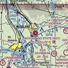
|
| Airport distance calculator |
|---|
|
|
| Sunrise and sunset |
|---|
|
Times for 25-Jul-2026
| | Local
(UTC-7) | | Zulu
(UTC) |
|---|
| Morning civil twilight | | 05:11 | | 12:11 |
| Sunrise | | 05:47 | | 12:47 |
| Sunset | | 20:48 | | 03:48 |
| Evening civil twilight | | 21:24 | | 04:24 |
|
| Current date and time |
|---|
| Zulu (UTC) | 25-Jul-2026 17:07:30 |
|---|
| Local (UTC-7) | 25-Jul-2026 10:07:30 |
|---|
|
| METAR |
|---|
KSPB
10nm SW | 251653Z AUTO 13011KT 10SM SCT050 18/12 A3000 RMK AO2 SLP158 T01830122
|
KKLS
15nm NW | 251656Z AUTO 17008KT 10SM BKN055 OVC070 18/12 A3000 RMK AO2 SLP163 T01830122 PNO $
|
KVUO
17nm S | 251653Z AUTO 16007KT 10SM OVC043 18/12 A3003 RMK AO2 SLP169 T01780117
|
KPDX
20nm S | 251653Z 17007KT 10SM FEW029 BKN043 18/11 A3002 RMK AO2 SLP163 T01780111 $
|
|
| TAF |
|---|
KPDX
20nm S | 251419Z 2514/2612 16005KT P6SM FEW015 SCT060 FM251800 23010G17KT P6SM SCT040 FM260400 21002KT P6SM BKN035
|
KHIO
23nm SW | 251120Z 2512/2612 20003KT P6SM FEW030 FM251800 22009G16KT P6SM SCT040 FM260300 20002KT P6SM SCT035
|
|
| NOTAMs |
|---|
NOTAMs are issued by the DoD/FAA and will open in a separate window not controlled by AirNav.
|
|

