FAA INFORMATION EFFECTIVE 11 JUNE 2026
Location
| FAA Identifier: | Y87 |
| Lat/Long: | 44-47-25.8590N 086-00-09.9713W
44-47.430983N 086-00.166188W
44.7905164,-86.0027698
(estimated) |
| Elevation: | 944 ft. / 287.7 m (surveyed) |
| Variation: | 04W (1985) |
| From city: | 3 miles SE of EMPIRE, MI |
| Time zone: | UTC -4 (UTC -5 during Standard Time) |
| Zip code: | 49630 |
Airport Operations
| Airport use: | Open to the public |
| Activation date: | 08/1948 |
| Control tower: | no |
| ARTCC: | MINNEAPOLIS CENTER |
| FSS: | LANSING FLIGHT SERVICE STATION |
| NOTAMs facility: | LAN (NOTAM-D service available) |
| Attendance: | UNATNDD |
| Wind indicator: | yes |
| Segmented circle: | yes |
| Lights: | ACTVT LIRL RWY 17/35 - CTAF. LIRL RWY 17/35 OTS NOV-APR. |
Airport Communications
| CTAF: | 122.9 |
| WX AWOS-3P at FKS (13 nm SW): | 118.325 (231-352-7573) |
| WX ASOS at TVC (18 nm E): | PHONE 231-486-2920 |
Nearby radio navigation aids
| VOR radial/distance | | VOR name | | Freq | | Var |
|---|
| TVCr293/20.7 | | TRAVERSE CITY VOR/DME | | 114.60 | | 02W |
Airport Services
| Parking: | hangars and tiedowns |
| Airframe service: | NONE |
| Powerplant service: | NONE |
| Bottled oxygen: | NONE |
| Bulk oxygen: | NONE |
Runway Information
Runway 17/35
| Dimensions: | 2600 x 50 ft. / 792 x 15 m |
| Surface: | asphalt, in fair condition |
| Weight bearing capacity: | |
| Runway edge lights: | low intensity |
| RUNWAY 17 | | RUNWAY 35 |
| Latitude: | 44-47.584667N | | 44-47.174833N |
| Longitude: | 086-00.231167W | | 086-00.058500W |
| Elevation: | 937.0 ft. | | 928.0 ft. |
| Traffic pattern: | left | | left |
| Runway heading: | 167 magnetic, 163 true | | 347 magnetic, 343 true |
| Displaced threshold: | 200 ft. | | 182 ft. |
| Declared distances: | LDA:2400 | | LDA:2400 |
| Markings: | basic, in good condition | | basic, in good condition |
| Runway end identifier lights: | no | | no |
| Obstructions: | 10 ft. trees, 200 ft. from runway, 125 ft. left and right of centerline
+9 FT FENCE, 90 FT DIST, 125 FT L/R. | | 16 ft. brush, 380 ft. from runway, 21 ft. right of centerline, 11:1 slope to clear
+15 FT ROAD, 105 FT DIST, 125 FT L/R. |
Runway 9/27
| Dimensions: | 2235 x 150 ft. / 681 x 46 m |
| Surface: | turf, in fair condition
UNEVEN ROLLING TRRN. |
| Runway edge markings: | RWY & DTHR MKD WITH 3 FT YELLOW CONES. |
| Operational restrictions: | CLSD DEC-MAR & WHEN SN COVD EXC FOR SKI EQUIPPED ACFT, NO SN REMOVAL. |
| RUNWAY 9 | | RUNWAY 27 |
| Latitude: | 44-47.468500N | | 44-47.510167N |
| Longitude: | 086-00.446167W | | 085-59.933333W |
| Elevation: | 940.0 ft. | | 929.0 ft. |
| Traffic pattern: | left | | left |
| Displaced threshold: | 217 ft. | | 270 ft. |
| Runway end identifier lights: | no | | no |
| Obstructions: | 17 ft. brush, 50 ft. from runway, 33 ft. left of centerline, 2:1 slope to clear | | 15 ft. road, 33 ft. from runway, 125 ft. left and right of centerline, 2:1 slope to clear
APCH RATIO 20:1 TO DTHR. |
Airport Ownership and Management from official FAA records
| Ownership: | Publicly-owned |
| Owner: | EMPIRE VILLAGE/TWP
PO BOX 204
EMPIRE, MI 49630-0204
Phone 231-326-5466
EMPIRE VILLAGE OFC 231-326-5466, EMPIRE TWP OFC 231-326-5182. |
| Manager: | LANCE ROMAN
PO BOX 204
EMPIRE, MI 49630-0204
Phone 231-326-5194 |
Additional Remarks
| - | DEER, BIRDS & WILDLIFE ON & INVOF ARPT. |
| - | CAMPGROUND ADJACENT TO ARPT; CALL 231-326-5285. |
| - | RWY 35 WIND SOCK 110 FT EAST OF RWY CNTRLN. |
| - | FOR CD CTC MINNEAPOLIS ARTCC AT 651-463-5588. |
Instrument Procedures
There are no published instrument procedures at Y87.
Some nearby airports with instrument procedures:
KFKS - Frankfort Dow Memorial Field (13 nm SW)
KTVC - Cherry Capital Airport (18 nm E)
KMBL - Manistee County/Blacker Airport (33 nm S)
KACB - Antrim County Airport (36 nm E)
KCAD - Wexford County Airport (40 nm SE)
|
|

Road maps at:
MapQuest
Bing
Google
| Aerial photo |
|---|
WARNING: Photo may not be current or correct
 View from the south
Do you have a better or more recent aerial photo of William B Bolton Airport that you would like to share? If so, please send us your photo.
|
| Sectional chart |
|---|
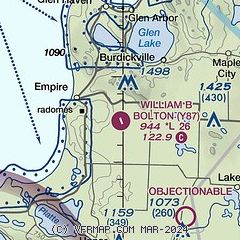
|
| Airport distance calculator |
|---|
|
|
| Sunrise and sunset |
|---|
|
Times for 11-Jun-2026
| | Local
(UTC-4) | | Zulu
(UTC) |
|---|
| Morning civil twilight | | 05:22 | | 09:22 |
| Sunrise | | 05:59 | | 09:59 |
| Sunset | | 21:28 | | 01:28 |
| Evening civil twilight | | 22:05 | | 02:05 |
|
| Current date and time |
|---|
| Zulu (UTC) | 11-Jun-2026 16:17:17 |
|---|
| Local (UTC-4) | 11-Jun-2026 12:17:17 |
|---|
|
| METAR |
|---|
KFKS
13nm SW | 111555Z AUTO 25008KT 10SM SCT009 19/17 A2978 RMK AO2
|
KTVC
19nm E | 111553Z 25010KT 10SM OVC013 22/19 A2974 RMK AO2 SLP070 T02220189
|
|
| TAF |
|---|
KTVC
19nm E | 111425Z 1114/1212 24008KT P6SM OVC012 FM111600 25009KT P6SM SCT015 FM120100 17009G24KT 3SM TSRA BR OVC030CB WS020/20045KT FM120500 24012G30KT 6SM BR VCSH OVC014 WS020/21050KT FM120800 25009G22KT P6SM SCT045
|
|
| NOTAMs |
|---|
NOTAMs are issued by the DoD/FAA and will open in a separate window not controlled by AirNav.
|
|

