FAA INFORMATION EFFECTIVE 09 JULY 2026
Location
| FAA Identifier: | TVC |
| Lat/Long: | 44-44-29.6830N 085-34-54.7320W
44-44.494717N 085-34.912200W
44.7415786,-85.5818700
(estimated) |
| Elevation: | 623.9 ft. / 190.2 m (surveyed) |
| Variation: | 05W (1985) |
| From city: | 2 miles S of TRAVERSE CITY, MI |
| Time zone: | UTC -4 (UTC -5 during Standard Time) |
| Zip code: | 49686 |
Airport Operations
| Airport use: | Open to the public |
| Activation date: | 04/1940 |
| Control tower: | yes |
| ARTCC: | MINNEAPOLIS CENTER |
| FSS: | LANSING FLIGHT SERVICE STATION |
| NOTAMs facility: | TVC (NOTAM-D service available) |
| Attendance: | 0400-0100
DURG HRS WHEN ARPT IS UNATNDD CALL ARPT OPNS 231-313-0928. FOR FBO HRS OF OPS CALL 231-929-1126. |
| Wind indicator: | lighted |
| Segmented circle: | yes |
| Lights: | WHEN ATCT CLSD ACTVT MALSR RWY 10 & 28; HIRL RWY 10/28; MIRL RWY 18/36 - CTAF. PAPI RWY 10 & 28; VASI RWY 18 & 36 OPR CONSLY. |
| Beacon: | white-green (lighted land airport)
Operates sunset to sunrise. |
| Landing fee: | yes |
| Fire and rescue: | ARFF index B |
| Airline operations: | 48 HR PPR FOR UNSKED ACR OPS WITH OVER 30 PSGR SEATS - CALL AMGR. |
Airport Communications
| CTAF: | 124.2 |
| UNICOM: | 122.95 |
| ATIS: | 119.175 |
| WX ASOS: | PHONE 231-486-2920 |
| TRAVERSE CITY GROUND: | 121.8 348.6 [0700 - 2100 EST; 0700 - 2200 EDT] |
| TRAVERSE CITY TOWER: | 124.2 348.6 [0700 - 2100 EST; 0700 - 2200 EDT] |
- APCH/DEP SVC PRVDD BY MINNEAPOLIS ARTCC ON 132.9/338.3 (TRAVERSE CITY RCAG).
Nearby radio navigation aids
| VOR radial/distance | | VOR name | | Freq | | Var |
|---|
| TVCr345/4.6 | | TRAVERSE CITY VOR/DME | | 114.60 | | 02W |
| CGGr282/(36.6) | | GRAYLING VOR | | 109.80 | | 06W |
| NDB name | | Hdg/Dist | | Freq | | Var | | ID |
|---|
| GWENN | | 279/6.5 | | 365 | | 05W | | TV | - ...- |
| GRAYLING | | 275/32.1 | | 359 | | 06W | | GYG | --. -.-- --. |
Airport Services
| Fuel available: | 100LL JET-A+
100LL:100LL SELF SVC FUEL AVBL WITH CREDIT CARD DURG FBO HRS ONLY. |
| Parking: | hangars and tiedowns |
| Airframe service: | MAJOR |
| Powerplant service: | MAJOR |
Runway Information
Runway 10/28
| Dimensions: | 7016 x 150 ft. / 2138 x 46 m |
| Surface: | asphalt/grooved, in fair condition |
| Weight bearing capacity: | | Single wheel: | 116.0 | | Double wheel: | 193.0 | | Double tandem: | 326.0 |
|
| Runway edge lights: | high intensity |
| RUNWAY 10 | | RUNWAY 28 |
| Latitude: | 44-44.471010N | | 44-44.396247N |
| Longitude: | 085-35.451488W | | 085-33.834950W |
| Elevation: | 623.9 ft. | | 606.9 ft. |
| Traffic pattern: | left | | left |
| Runway heading: | 099 magnetic, 094 true | | 279 magnetic, 274 true |
| Declared distances: | TORA:7016 TODA:7016 ASDA:7016 LDA:7016 | | TORA:7016 TODA:7016 ASDA:7016 LDA:7016 |
| Markings: | precision, in good condition | | precision, in good condition |
| Visual slope indicator: | 4-light PAPI on left (3.00 degrees glide path) | | 4-light PAPI on left (3.00 degrees glide path) |
| Approach lights: | MALSR: 1,400 foot medium intensity approach lighting system with runway alignment indicator lights | | MALSR: 1,400 foot medium intensity approach lighting system with runway alignment indicator lights |
| Runway end identifier lights: | no | | no |
| Touchdown point: | yes, no lights | | yes, no lights |
| Instrument approach: | ILS/DME | | ILS |
| Obstructions: | 80 ft. tree, 3209 ft. from runway, 187 ft. right of centerline, 37:1 slope to clear | | 452 ft. tower, lighted, 16493 ft. from runway, 2359 ft. left of centerline, 36:1 slope to clear |
Runway 18/36
| Dimensions: | 5378 x 150 ft. / 1639 x 46 m |
| Surface: | asphalt/grooved, in fair condition |
| Weight bearing capacity: | | Single wheel: | 79.0 | | Double wheel: | 127.0 | | Double tandem: | 215.0 |
|
| Runway edge lights: | medium intensity |
| RUNWAY 18 | | RUNWAY 36 |
| Latitude: | 44-45.016835N | | 44-44.131795N |
| Longitude: | 085-35.261257W | | 085-35.265005W |
| Elevation: | 616.8 ft. | | 623.4 ft. |
| Traffic pattern: | left | | left |
| Runway heading: | 185 magnetic, 180 true | | 005 magnetic, 000 true |
| Displaced threshold: | 272 ft. | | no |
| Declared distances: | TORA:5378 TODA:5378 ASDA:5108 LDA:4838 | | TORA:5378 TODA:5378 ASDA:5108 LDA:5108 |
| Markings: | nonprecision, in good condition | | nonprecision, in good condition |
| Visual slope indicator: | 4-box VASI on left (3.00 degrees glide path) | | 4-box VASI on left (3.50 degrees glide path) |
| Runway end identifier lights: | no | | no |
| Touchdown point: | yes, no lights | | yes, no lights |
| Obstructions: | 70 ft. tree, 1199 ft. from runway, 148 ft. left of centerline, 14:1 slope to clear
DTHR APCH SLOPE 19:1. | | 14 ft. fence, 769 ft. from runway, 40:1 slope to clear |
Airport Ownership and Management from official FAA records
| Ownership: | Publicly-owned |
| Owner: | NORTHWEST RGNL AIRPORT AUTHORITY
727 FLY DONT DR
TRAVERSE CITY, MI 49686-3591
Phone 231-947-2250 |
| Manager: | KEVIN C KLEIN, AAE
727 FLY DONT DR
TRAVERSE CITY, MI 49686-3591
Phone 231-947-2250 |
Additional Remarks
| A39-18/36 | PCR VALUE: 310/F/B/X/T |
| A39-10/28 | PCR VALUE: 470/F/B/X/T |
| - | ALL TSNT ACFT CHRGD LDG, OVNGT RAMP PRKG FEE EXC MIL. |
| - | FOR CD WHEN ATCT IS CLSD CTC FSS VIA RCO, IF UNA CTC MINNEAPOLIS ARTCC AT 651-463-5588. |
| - | COLD TEMPERATURE AIRPORT. ALTITUDE CORRECTION REQUIRED AT OR BELOW -21C. |
| - | 48 HR PPR FOR UNSKED ACR OPS GTR THAN 100000 LB. PPR FOR ACFT OPS WITH WINGSPAN GTR THAN 118 FT. PPR FOR ACFT OPS GTR THAN 12500 LB FOR TWY J & EAST RAMP. TWY C-2/C-3 EAST OF TWY C NOT AVBL TO ACR ACFT. PPR FOR ACFT OPS GTR THAN 60000 LB ON NORTH RAMP. NORTH RAMP CLSD TO ACFT OPS GTR THAN 100000 LB. NO GA ACFT ON THE ACR RAMP. NO ACFT WITH WINGSPAN GTR THAN 40 FT BTN GA RAMP & SOUTH RAMP. PUSHBACK ADZYS ON THE TRML RAMP ARE NOT PRVDD BY ATC. DIVERTING NON-BASED ACR ACFT CTC ARPT OPS AT 231-313-0928 PRIOR TO DIVERTING. NO CUST SVC AVBL. |
| - | BIRDS ON AND INVOF ARPT. |
| - | SNOW REMOVAL OPNS IN PROGRESS WINTER MONTHS; SNOW COMMAND WILL BE MONITORING CTAF DURING NON-ATCT HOURS. ACFT LNDG/DEPARTING TVC SHOULD ANNOUNCE THEIR INTENTIONS ON CTAF WHEN ATCT CLSD. |
| - | TWY C-2/C-3 EAST OF TWY C NOT AVBL TO ACR ACFT. |
| - | FLIGHT CREWS SHOULD READ BACK ALL ADZY INFO PRVDD BY SNOW COMMAND. |
| - | ARPT SFC COND UNMON BTN 0100 - 0400. |
| - | USCG - PPR CTC TRAVERSE CITY FM 21 PRIMARY, 345.0 SECONDARY 15 MINS PRIOR TO ENTERING CG RAMP. |
| - | PARASAILING OPNS 1.5 NM NORTHEAST OF ARPT FROM MEMORIAL DAY TO LABOR DAY 600 FT AGL FROM SR-SS DAILY. |
Instrument Procedures
NOTE: All procedures below are presented as PDF files. If you need a reader for these files, you should download the free Adobe Reader.NOT FOR NAVIGATION. Please procure official charts for flight.
FAA instrument procedures published for use from 09 July 2026 at 0901Z to 06 August 2026 at 0900Z.
IAPs - Instrument Approach Procedures |
|---|
| ILS OR LOC RWY 10 | |
download (306KB) |
| ILS OR LOC RWY 28 | |
download (311KB) |
| RNAV (GPS) RWY 10 | |
download (265KB) |
| RNAV (GPS) RWY 18 | |
download (206KB) |
| RNAV (GPS) RWY 18 | |
download (206KB) |
| RNAV (GPS) RWY 28 | |
download (287KB) |
| RNAV (GPS) RWY 36 | |
download (262KB) |
| NOTE: Special Alternate Minimums apply | |
download (140KB) |
| NOTE: Special Take-Off Minimums/Departure Procedures apply | |
download (346KB) |
Other nearby airports with instrument procedures:
KACB - Antrim County Airport (22 nm NE)
KFKS - Frankfort Dow Memorial Field (27 nm W)
KCAD - Wexford County Airport (29 nm S)
KCVX - Charlevoix Municipal Airport (36 nm N)
KGOV - Grayling Army Airfield (37 nm E)
|
|

Road maps at:
MapQuest
Bing
Google
| Aerial photo |
|---|
WARNING: Photo may not be current or correct

Do you have a better or more recent aerial photo of Cherry Capital Airport that you would like to share? If so, please send us your photo.
|
| Sectional chart |
|---|
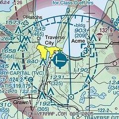
|
CAUTION: Diagram may not be current
 Download PDF
of official airport diagram from the FAA
| Airport distance calculator |
|---|
|
|
| Sunrise and sunset |
|---|
|
Times for 20-Jul-2026
| | Local
(UTC-4) | | Zulu
(UTC) |
|---|
| Morning civil twilight | | 05:42 | | 09:42 |
| Sunrise | | 06:17 | | 10:17 |
| Sunset | | 21:21 | | 01:21 |
| Evening civil twilight | | 21:56 | | 01:56 |
|
| Current date and time |
|---|
| Zulu (UTC) | 20-Jul-2026 04:04:32 |
|---|
| Local (UTC-4) | 20-Jul-2026 00:04:32 |
|---|
|
| METAR |
|---|
| KTVC | 200353Z AUTO 17003KT 9SM CLR 17/15 A2997 RMK AO2 SLP147 T01670150
|
|
| TAF |
|---|
| KTVC | 191720Z 1918/2018 02005KT 6SM FU SCT060 FM200200 VRB03KT 6SM FU FEW250 FM200800 20004KT 6SM FU SCT150 FM201400 21009G23KT 6SM FU SCT100
|
|
| NOTAMs |
|---|
NOTAMs are issued by the DoD/FAA and will open in a separate window not controlled by AirNav.
|
|


