FAA INFORMATION EFFECTIVE 17 APRIL 2025
Location
| FAA Identifier: | GOV |
| Lat/Long: | 44-40-49.2000N 084-43-43.9000W
44-40.820000N 084-43.731667W
44.6803333,-84.7288611
(estimated) |
| Elevation: | 1158.1 ft. / 353.0 m (surveyed) |
| Variation: | 06W (2000) |
| From city: | 1 mile NW of GRAYLING, MI |
| Time zone: | UTC -4 (UTC -5 during Standard Time) |
| Zip code: | 49738 |
Airport Operations
| Airport use: | Open to the public |
| Activation date: | 05/1941 |
| Control tower: | yes |
| ARTCC: | MINNEAPOLIS CENTER |
| FSS: | LANSING FLIGHT SERVICE STATION |
| NOTAMs facility: | GOV (NOTAM-D service available) |
| Attendance: | OCT-MAR MON-FRI 0800-2000, APR-SEP MON-FRI 0800-2400
EXC FEDERAL HOLS. |
| Pattern altitude: | ROTOR WING 1700 FT MSL; FIXED WING 2200 FT MSL; OVHD 2700 FT MSL. |
| Wind indicator: | lighted |
| Segmented circle: | yes |
| Lights: | ACTVT REIL RWY 14, 32, 05, & 23; PAPI RWY 14, 32, 05, & 23; MIRL RWY 14/32 & 05/23 - CTAF. |
| Beacon: | white-white-green (lighted military airport)
Operates sunset to sunrise. |
| Airline operations: | ARFF CAPABILITIES LTD OCT-MAY. |
Airport Communications
| CTAF: | 126.2 |
| ATIS: | 119.075 |
| WX ASOS: | PHONE 989-348-3127 |
| GRAYLING GROUND: | 121.9 [1300-0500Z++MON-FRI 1 APR-30 SEP; 1300-0100Z++MON-FRI 1 OCT-31 MAR] |
| GRAYLING TOWER: | 126.2 [1300-0500Z++MON-FRI 1 APR-30 SEP; 1300-0100Z++MON-FRI 1 OCT-31 MAR] |
| EMERG: | 121.5 243.0 |
| GCA: | 317.0 48.6FM |
| OPS: | 122.8 |
| WX ASOS at HTL (19 nm S): | 118.05 (989-200-3352) |
| WX ASOS at GLR (20 nm N): | 118.375 (989-732-1571) |
- APCH/DEP SVC PRVDD BY MINNEAPOLIS ARTCC ON 125.475/269.45 (ALPENA RCAG).
Nearby radio navigation aids
| VOR radial/distance | | VOR name | | Freq | | Var |
|---|
| CGG at field | | GRAYLING VOR | | 109.80 | | 06W |
| TVCr091/35.0 | | TRAVERSE CITY VOR/DME | | 114.60 | | 02W |
| NDB name | | Hdg/Dist | | Freq | | Var | | ID |
|---|
| GRAYLING | | 141/5.9 | | 359 | | 06W | | GYG | --. -.-- --. |
Airport Services
| Fuel available: | 100LL JET-A+
100LL:100LL & JET A+ AVBL H24 SELF SVC VIA CREDIT CARD. FOR FUEL SUPPORT CTC BASOPS AT 989-344-4301, 24 HR PN FOR FUEL SUPPORT OUTSIDE OPRG HRS. |
| Parking: | tiedowns |
| Bottled oxygen: | NONE |
| Bulk oxygen: | NONE |
Runway Information
Runway 14/32
| Dimensions: | 5005 x 150 ft. / 1526 x 46 m |
| Surface: | asphalt, in good condition |
| Weight bearing capacity: | |
| Runway edge lights: | medium intensity |
| RUNWAY 14 | | RUNWAY 32 |
| Latitude: | 44-40.900545N | | 44-40.307183N |
| Longitude: | 084-44.183302W | | 084-43.382755W |
| Elevation: | 1152.9 ft. | | 1149.1 ft. |
| Traffic pattern: | right | | left |
| Runway heading: | 142 magnetic, 136 true | | 322 magnetic, 316 true |
| Displaced threshold: | no | | 293 ft. |
| Markings: | nonprecision, in fair condition | | nonprecision, in fair condition |
| Visual slope indicator: | 4-light PAPI on left (3.00 degrees glide path)
PAPI UNUSBL BYD 8 DEGS LEFT OF CNTRLN. | | 4-light PAPI on left (3.50 degrees glide path) |
| Runway end identifier lights: | yes | | yes |
| Touchdown point: | yes, no lights | | yes, no lights |
| Obstructions: | 60 ft. tree, 1438 ft. from runway, 435 ft. right of centerline, 20:1 slope to clear | | 61 ft. trees, 939 ft. from runway, 200 ft. right of centerline, 12:1 slope to clear
APCH RATIO 20:1 TO DTHR OVR 68 FT TREES, 1423 FT DIST, 125 FT R. |
Runway 5/23
| Dimensions: | 5000 x 150 ft. / 1524 x 46 m |
| Surface: | concrete, in fair condition
IREG SFC; FOD LCTD THRUT RWY. |
| Weight bearing capacity: | |
| Runway edge lights: | medium intensity |
| RUNWAY 5 | | RUNWAY 23 |
| Latitude: | 44-40.750610N | | 44-41.321010N |
| Longitude: | 084-44.096317W | | 084-43.265092W |
| Elevation: | 1151.4 ft. | | 1158.0 ft. |
| Traffic pattern: | left | | right |
| Runway heading: | 052 magnetic, 046 true | | 232 magnetic, 226 true |
| Markings: | nonprecision, in fair condition | | nonprecision, in fair condition |
| Visual slope indicator: | 4-light PAPI on left (4.00 degrees glide path) | | 4-light PAPI on left (3.00 degrees glide path) |
| Runway end identifier lights: | yes | | yes |
| Touchdown point: | yes, no lights | | yes, no lights |
| Obstructions: | 75 ft. trees, 1362 ft. from runway, 25 ft. right of centerline, 15:1 slope to clear | | 58 ft. trees, 1277 ft. from runway, 125 ft. left of centerline, 18:1 slope to clear |
Airport Ownership and Management from official FAA records
| Ownership: | U.S. Army |
| Owner: | US ARMY
MI DEPT OF MILITARY & VETERANS AFF, 3411 N MLK BLVD
LANSING, MI 48906-2934
Phone 517-483-5645 |
| Manager: | SCOTT KARNER
JMTC GAAF BLDG 1160, CAMP GRAYLING
GRAYLING, MI 49738
Phone 989-344-4301
C989-344-4301 (FLT OPS) OR C517-897-8266 (FLT OPS SUPVR CELL); C989-344-4310 (AMGR CELL). |
Additional Remarks
| A39-05/23 | PCN 18 DRG FROST CONDS. |
| A39-14/32 | PCN 59 DRG FROST CONDS. |
| A30A-05 | OPEN TO VFR LDGS SR-SS. |
| - | MILITARY: ALL HAZUS CARGO MUST BE APVD BY AIRFIELD MGR. |
| - | ALL AIRFIELD SIGNS UNLGTD. |
| - | EXP CLOSURE OR RDCD SVC PER NOTAM. |
| - | PAVEMENT EVAL NOT CURRENT. ALL AMC ACFT CTC MGMT FOR WAIVERS & RSTRNS. |
| - | WILDLIFE ON & INVOF ARPT. |
| - | EXTSV MIL HEL TFC JUN THRU AUG. |
| - | PARTS OF THE AIRFIELD CLSD DRG WINTER MONTHS - CK NOTAMS. |
| - | CIVILIAN TRML BLDG ACES 5-3-2-1-*. |
| - | FOR FICON C989-344-4301, UNMON OUTSIDE OPRG HRS. |
| - | MILITARY: SVC: UNAVBL EXC 24 HR PPR 989-344-4301, ACFT MUST MEET PPR TIME WI 30 MINS. |
Instrument Procedures
NOTE: All procedures below are presented as PDF files. If you need a reader for these files, you should download the free Adobe Reader.NOT FOR NAVIGATION. Please procure official charts for flight.
FAA instrument procedures published for use from 17 April 2025 at 0901Z to 15 May 2025 at 0900z.
IAPs - Instrument Approach Procedures |
|---|
| RNAV (GPS) RWY 14 | |
download (243KB) |
| VOR RWY 14 | |
download (253KB) |
| NDB RWY 14 | |
download (213KB) |
| NOTE: Special Alternate Minimums apply | |
download (155KB) |
| NOTE: Special Take-Off Minimums/Departure Procedures apply | |
download (122KB) |
Other nearby airports with instrument procedures:
KHTL - Roscommon County/Blodgett Memorial Airport (19 nm S)
KGLR - Gaylord Regional Airport (20 nm N)
KACB - Antrim County Airport (27 nm NW)
KBFA - Boyne Mountain Airport (30 nm N)
N98 - Boyne City Municipal Airport (34 nm N)
|
|

Road maps at:
MapQuest
Bing
Google
| Aerial photo |
|---|
WARNING: Photo may not be current or correct
 Photo taken 04-Jul-2006
Do you have a better or more recent aerial photo of Grayling Army Airfield that you would like to share? If so, please send us your photo.
|
| Sectional chart |
|---|
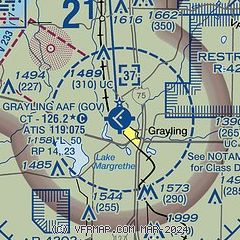
|
| Airport distance calculator |
|---|
|
|
| Sunrise and sunset |
|---|
|
Times for 10-May-2025
| | Local
(UTC-4) | | Zulu
(UTC) |
|---|
| Morning civil twilight | | 05:44 | | 09:44 |
| Sunrise | | 06:18 | | 10:18 |
| Sunset | | 20:53 | | 00:53 |
| Evening civil twilight | | 21:26 | | 01:26 |
|
| Current date and time |
|---|
| Zulu (UTC) | 10-May-2025 19:42:03 |
|---|
| Local (UTC-4) | 10-May-2025 15:42:03 |
|---|
|
| METAR |
|---|
| KGOV | 101855Z AUTO 36011G18KT 10SM FEW340 18/05 A3015 RMK AO2 SLP217 T01830045 $
|
KHTL
20nm S | 101853Z AUTO 32012G20KT 10SM CLR 21/03 A3015 RMK AO2 SLP210 T02060033
|
|
| NOTAMs |
|---|
NOTAMs are issued by the DoD/FAA and will open in a separate window not controlled by AirNav.
|
|


