FAA INFORMATION EFFECTIVE 14 MAY 2026
Location
| FAA Identifier: | BFA |
| Lat/Long: | 45-09-57.0295N 084-55-26.8100W
45-09.950492N 084-55.446833W
45.1658415,-84.9241139
(estimated) |
| Elevation: | 719 ft. / 219.2 m (surveyed) |
| Variation: | 06W (2000) |
| From city: | 1 mile W of BOYNE FALLS, MI |
| Time zone: | UTC -4 (UTC -5 during Standard Time) |
| Zip code: | 49712 |
Airport Operations
| Airport use: | Open to the public |
| Activation date: | 08/1964 |
| Control tower: | no |
| ARTCC: | MINNEAPOLIS CENTER |
| FSS: | LANSING FLIGHT SERVICE STATION |
| NOTAMs facility: | BFA (NOTAM-D service available) |
| Attendance: | UNATNDD |
| Wind indicator: | lighted |
| Segmented circle: | yes |
| Lights: | ACTVT REIL RWY 17 & 35; PAPI RWY 35; MIRL RWY 17/35 - CTAF. |
| Landing fee: | yes, FOR LDG FEES CTC AMGR FOR DTLS. |
Airport Communications
| CTAF/UNICOM: | 122.8 |
| WX AWOS-3PT: | 118.675 (231-330-8677) |
| WX ASOS at GLR (13 nm SE): | 118.375 (989-732-1571) |
| WX AWOS-3P at MGN (16 nm N): | 119.925 (231-347-5231) |
| WX AWOS-3P at ACB (16 nm SW): | 119.275 (231-533-8941) |
| WX AWOS-3P at CVX (17 nm NW): | 120.0 (231-237-9703) |
- APCH/DEP SVC PRVDD BY MINNEAPOLIS ARTCC ON FREQS 134.6/354.05 (PELLSTON RCAG).
Nearby radio navigation aids
| VOR radial/distance | | VOR name | | Freq | | Var |
|---|
| PLNr207/30.0 | | PELLSTON VORTAC | | 111.80 | | 06W |
| CGGr350/(30.2) | | GRAYLING VOR | | 109.80 | | 06W |
| TVCr044/40.0 | | TRAVERSE CITY VOR/DME | | 114.60 | | 02W |
| NDB name | | Hdg/Dist | | Freq | | Var | | ID |
|---|
| BANGU | | 338/10.3 | | 375 | | 06W | | GL | --. .-.. |
| GRAYLING | | 357/25.3 | | 359 | | 06W | | GYG | --. -.-- --. |
Airport Services
| Fuel available: | 100LL
100LL:AVBL H24 SELF SVC VIA CREDIT CARD. |
| Parking: | tiedowns |
Runway Information
Runway 17/35
| Dimensions: | 5187 x 100 ft. / 1581 x 30 m |
| Surface: | asphalt/grooved, in excellent condition |
| Runway edge lights: | medium intensity |
| RUNWAY 17 | | RUNWAY 35 |
| Latitude: | 45-10.369817N | | 45-09.531167N |
| Longitude: | 084-55.559167W | | 084-55.334500W |
| Elevation: | 703.0 ft. | | 719.0 ft. |
| Traffic pattern: | left | | left |
| Runway heading: | 175 magnetic, 169 true | | 355 magnetic, 349 true |
| Displaced threshold: | 300 ft. | | 500 ft. |
| Markings: | nonprecision, in good condition | | nonprecision, in good condition |
| Visual slope indicator: | | | 2-light PAPI on left (3.00 degrees glide path) |
| Runway end identifier lights: | yes | | yes |
| Touchdown point: | yes, no lights | | yes, no lights |
| Obstructions: | 15 ft. road, 200 ft. from runway, 55 ft. right of centerline
+15 FT ROAD, 0-199 FT DIST, 100 FT L TO 90 FT R. | | 22 ft. trees, 200 ft. from runway, 44 ft. right of centerline
+25 FT TREES, 200-500 FT DIST, 165 FT R. |
Airport Ownership and Management from official FAA records
| Ownership: | Privately-owned |
| Owner: | BOYNE USA INC
1 BOYNE MOUNTAIN RD
BOYNE FALLS, MI 49713-9642
Phone 231-549-6001 |
| Manager: | CHRIS ADAMS
BOYNE MOUNTAIN RESORT, PO BOX 19
BOYNE FALLS, MI 49713-0019
Phone 231-549-6852 |
Additional Remarks
| - | DEER, BIRDS, & WILDLIFE ON & INVOF ARPT. |
| - | FOR CD CTC MINNEAPOLIS ARTCC AT 651-463-5588. |
| - | RWY 17/35 TREES, BLDGS, & ROADS IN PRI SFC. |
| - | PEDESTRIANS INVOF RWY ENVIRONMENT - LODGING 200 FT WEST OF RWY 35 DESIGNATOR. |
Instrument Procedures
NOTE: All procedures below are presented as PDF files. If you need a reader for these files, you should download the free Adobe Reader.NOT FOR NAVIGATION. Please procure official charts for flight.
FAA instrument procedures published for use from 14 May 2026 at 0901Z to 11 June 2026 at 0900Z.
IAPs - Instrument Approach Procedures |
|---|
| RNAV (GPS) RWY 17 | |
download (250KB) |
| RNAV (GPS) RWY 35 | |
download (213KB) |
| NOTE: Special Take-Off Minimums/Departure Procedures apply | |
download (347KB) |
Other nearby airports with instrument procedures:
N98 - Boyne City Municipal Airport (4 nm NW)
KGLR - Gaylord Regional Airport (13 nm SE)
KMGN - Harbor Springs Airport (16 nm N)
KACB - Antrim County Airport (16 nm SW)
KCVX - Charlevoix Municipal Airport (17 nm NW)
|
|

Road maps at:
MapQuest
Bing
Google
| Aerial photo |
|---|
WARNING: Photo may not be current or correct
 Photo by Terry Graham
Photo taken 30-Sep-2018
looking south.
Photo by Terry Graham
Photo taken 30-Sep-2018
looking south.
Do you have a better or more recent aerial photo of Boyne Mountain Airport that you would like to share? If so, please send us your photo.
|
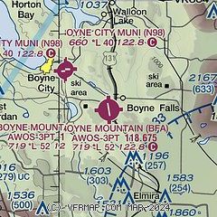
| Sectional chart |
|---|
|
| Airport distance calculator |
|---|
|
|
| Sunrise and sunset |
|---|
|
Times for 10-Jun-2026
| | Local
(UTC-4) | | Zulu
(UTC) |
|---|
| Morning civil twilight | | 05:16 | | 09:16 |
| Sunrise | | 05:53 | | 09:53 |
| Sunset | | 21:25 | | 01:25 |
| Evening civil twilight | | 22:02 | | 02:02 |
|
| Current date and time |
|---|
| Zulu (UTC) | 10-Jun-2026 12:33:11 |
|---|
| Local (UTC-4) | 10-Jun-2026 08:33:11 |
|---|
|
| METAR |
|---|
| KBFA | 101215Z AUTO 23003KT 4SM BR OVC004 18/18 A2979 RMK AO2
|
KGLR
14nm SE | 101153Z AUTO 00000KT 4SM BR OVC002 17/17 A2981 RMK AO2 SLP092 70062 T01720172 10172 20167 58006
|
KACB
16nm SW | 101215Z AUTO 00000KT 1/2SM FG OVC002 17/17 A2980 RMK AO2 T01700165
|
KMGN
16nm N | 101215Z AUTO 27004KT M1/4SM FG OVC002 16/15 A2978 RMK AO2 T01600155
|
KCVX
17nm NW | 101215Z AUTO 23005KT 2 1/2SM BR OVC002 17/17 A2979 RMK AO2
|
|
| TAF |
|---|
KPLN
25nm N | 101127Z 1012/1112 VRB04KT 1 1/2SM BR BKN003 FM101400 VRB04KT P6SM BKN003 FM101600 VRB04KT P6SM SCT019 FM101800 24005KT P6SM BKN060 FM110300 14004KT 5SM -SHRA BR VCTS BKN018CB FM110700 21008G20KT 4SM BR BKN019
|
|
| NOTAMs |
|---|
NOTAMs are issued by the DoD/FAA and will open in a separate window not controlled by AirNav.
|
|

