FAA INFORMATION EFFECTIVE 25 DECEMBER 2025
Location
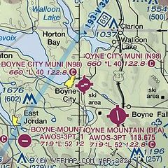
| FAA Identifier: | N98 |
| Lat/Long: | 45-12-31.7284N 084-59-23.5880W
45-12.528807N 084-59.393133W
45.2088134,-84.9898856
(estimated) |
| Elevation: | 659.6 ft. / 201.0 m (surveyed) |
| Variation: | 05W (1985) |
| From city: | 1 mile E of BOYNE CITY, MI |
| Time zone: | UTC -5 (UTC -4 during Daylight Saving Time) |
| Zip code: | 49712 |
Airport Operations
| Airport use: | Open to the public |
| Activation date: | 10/1947 |
| Control tower: | no |
| ARTCC: | MINNEAPOLIS CENTER |
| FSS: | LANSING FLIGHT SERVICE STATION |
| NOTAMs facility: | LAN (NOTAM-D service available) |
| Attendance: | UNATNDD |
| Wind indicator: | lighted |
| Segmented circle: | yes |
| Lights: | ACTVT REIL RWY 27; PAPI RWY 09; MIRL RWY 09/27 - 122.9. |
Airport Communications
| CTAF/UNICOM: | 122.8 |
| WX AWOS-3PT at BFA (4 nm SE): | 118.675 (231-330-8677) |
| WX AWOS-3P at CVX (13 nm NW): | 120.0 (231-237-9703) |
| WX AWOS-3P at MGN (13 nm N): | 119.925 (231-347-5231) |
| WX AWOS-3P at ACB (16 nm SW): | 119.275 (231-533-8941) |
| WX ASOS at GLR (17 nm SE): | 118.375 (989-732-1571) |
- APCH/DEP SVC PRVDD BY MINNEAPOLIS ARTCC (ZMP) ON FREQ 134.6/354.05 (PELLSTON RCAG).
Nearby radio navigation aids
| VOR radial/distance | | VOR name | | Freq | | Var |
|---|
| PLNr214/28.8 | | PELLSTON VORTAC | | 111.80 | | 06W |
| CGGr347/(33.5) | | GRAYLING VOR | | 109.80 | | 06W |
| NDB name | | Hdg/Dist | | Freq | | Var | | ID |
|---|
| BANGU | | 333/14.0 | | 375 | | 06W | | GL | --. .-.. |
| GRAYLING | | 352/28.4 | | 359 | | 06W | | GYG | --. -.-- --. |
Airport Services
| Fuel available: | 100LL
100LL:SELF SVC. |
| Parking: | tiedowns |
| Bottled oxygen: | NONE |
| Bulk oxygen: | NONE |
Runway Information
Runway 9/27
| Dimensions: | 4001 x 75 ft. / 1220 x 23 m |
| Surface: | asphalt, in good condition |
| Runway edge lights: | medium intensity |
| RUNWAY 9 | | RUNWAY 27 |
| Latitude: | 45-12.543998N | | 45-12.513615N |
| Longitude: | 084-59.858375W | | 084-58.927892W |
| Elevation: | 653.0 ft. | | 656.0 ft. |
| Traffic pattern: | left | | left |
| Runway heading: | 098 magnetic, 093 true | | 278 magnetic, 273 true |
| Displaced threshold: | 599 ft. | | no |
| Markings: | nonprecision, in good condition | | nonprecision, in good condition |
| Visual slope indicator: | 2-light PAPI on left (4.00 degrees glide path) | | |
| Runway end identifier lights: | no | | yes |
| Touchdown point: | yes, no lights | | yes, no lights |
| Obstructions: | 19 ft. road, 201 ft. from runway
+6 FT FENCE, 175 FT DIST; 19 FT ROAD, 197 FT DIST. | | 17 ft. road, 200 ft. from runway, 146 ft. left of centerline
5 FT TREE, 190 FT DIST, 115 & 125 FT R. |
Airport Ownership and Management from official FAA records
| Ownership: | Publicly-owned |
| Owner: | CITY OF BOYNE CITY
319 N LAKE ST
BOYNE CITY, MI 49712-2111
Phone 231-582-6597 |
| Manager: | MICHAEL CAIN
319 N LAKE ST
BOYNE CITY, MI 49712-2111
Phone 231-675-0636 |
Additional Remarks
| - | RWY 27 +250 FT HILL, 2 NM EAST, 16:1; +20 FT TREES, 480 FT DIST, 145 FT R, 14:1. |
| - | OVNGT PRKG FEE. |
| - | DEER & BIRDS ON & INVOF ARPT. |
| - | ADMIN BLDG ACES: PRESS 5, THEN 3 & 2 SIMUL, THEN 1. |
| - | FOR CD CTC MINNEAPOLIS ARTCC AT 651-463-5588. |
| - | FIRING RANGE NE OF FLD OPRS AT UNSKED TIMES, FOR ADZY CTC BOYNE CITY POLICE DEPT AT 231-582-6611. |
Instrument Procedures
NOTE: All procedures below are presented as PDF files. If you need a reader for these files, you should download the free Adobe Reader.NOT FOR NAVIGATION. Please procure official charts for flight.
FAA instrument procedures published for use from 25 December 2025 at 0901z to 22 January 2026 at 0900z.
IAPs - Instrument Approach Procedures |
|---|
| RNAV (GPS) RWY 09 | |
download (238KB) |
| RNAV (GPS) RWY 27 | |
download (215KB) |
| NOTE: Special Take-Off Minimums/Departure Procedures apply | |
download (272KB) |
Other nearby airports with instrument procedures:
KBFA - Boyne Mountain Airport (4 nm SE)
KCVX - Charlevoix Municipal Airport (13 nm NW)
KMGN - Harbor Springs Airport (13 nm N)
KACB - Antrim County Airport (16 nm SW)
KGLR - Gaylord Regional Airport (17 nm SE)
|
|

Road maps at:
MapQuest
Bing
Google
| Aerial photo |
|---|
WARNING: Photo may not be current or correct

Do you have a better or more recent aerial photo of Boyne City Municipal Airport that you would like to share? If so, please send us your photo.
|
| Sectional chart |
|---|
|
| Airport distance calculator |
|---|
|
|
| Sunrise and sunset |
|---|
|
Times for 20-Jan-2026
| | Local
(UTC-5) | | Zulu
(UTC) |
|---|
| Morning civil twilight | | 07:41 | | 12:41 |
| Sunrise | | 08:13 | | 13:13 |
| Sunset | | 17:29 | | 22:29 |
| Evening civil twilight | | 18:02 | | 23:02 |
|
| Current date and time |
|---|
| Zulu (UTC) | 20-Jan-2026 19:42:30 |
|---|
| Local (UTC-5) | 20-Jan-2026 14:42:30 |
|---|
|
| METAR |
|---|
KBFA
4nm SE | 201915Z AUTO 23011G18KT 190V270 3/4SM -SN HZ SCT003 M12/M15 A3013 RMK AO2
|
KCVX
13nm NW | 201915Z AUTO 24015G22KT 1/4SM SN HZ OVC017 M12/M15 A3012 RMK AO2
|
KMGN
14nm N | 201915Z AUTO 25015G24KT 1 3/4SM -SN SCT011 BKN019 OVC025 M11/M16 A3009 RMK AO2 T11121160
|
KACB
16nm SW | 201915Z AUTO 24011G17KT 220V280 5SM HZ OVC027 M11/M18 A3017 RMK AO2 T11071177
|
KGLR
17nm SE | 201909Z AUTO 24018KT 3/4SM -SN BKN016 OVC024 M14/M17 A3006 RMK AO2 P0000 T11391172
|
|
| TAF |
|---|
KPLN
23nm N | 201724Z 2018/2118 26012G25KT 5SM -SN BR FEW019 BKN025 TEMPO 2018/2022 2SM -SN BR FM202200 25015G25KT P6SM BKN020 TEMPO 2101/2105 4SM -SN FM210900 VRB04KT 6SM -SN OVC030 FM211600 22005KT 6SM -SN OVC025
|
|
| NOTAMs |
|---|
NOTAMs are issued by the DoD/FAA and will open in a separate window not controlled by AirNav.
|
|

