FAA INFORMATION EFFECTIVE 16 APRIL 2026
Location
| FAA Identifier: | CVX |
| Lat/Long: | 45-18-17.5000N 085-16-31.1000W
45-18.291667N 085-16.518333W
45.3048611,-85.2753056
(estimated) |
| Elevation: | 668.9 ft. / 203.9 m (surveyed) |
| Variation: | 05W (1985) |
| From city: | 1 mile SW of CHARLEVOIX, MI |
| Time zone: | UTC -4 (UTC -5 during Standard Time) |
| Zip code: | 49720 |
Airport Operations
| Airport use: | Open to the public |
| Activation date: | 03/1945 |
| Control tower: | no |
| ARTCC: | MINNEAPOLIS CENTER |
| FSS: | LANSING FLIGHT SERVICE STATION |
| NOTAMs facility: | CVX (NOTAM-D service available) |
| Attendance: | JUN-AUG 0800-1900, SEP-MAY 0800-1700
UNATNDD MAJOR HOLS. |
| Wind indicator: | lighted |
| Segmented circle: | yes |
| Lights: | ACTVT REIL RWY 09 & 27; PAPI RWY 09 & 27; NSTD MIRL RWY 09/27 - CTAF. |
| Beacon: | white-green (lighted land airport)
Operates sunset to sunrise. |
| Landing fee: | yes, LDG FEE WAIVED WITH MNM FUEL PURCHASE. |
Airport Communications
| CTAF/UNICOM: | 122.8 |
| WX AWOS-3P: | 120.0 (231-237-9703) |
| WX AWOS-3P at MGN (17 nm NE): | 119.925 (231-347-5231) |
| WX AWOS-3PT at BFA (17 nm SE): | 118.675 (231-330-8677) |
| WX AWOS-3P at ACB (19 nm S): | 119.275 (231-533-8941) |
- APCH/DEP SVC PRVDD BY MINNEAPOLIS ARTCC ON FREQS 134.6/354.05 (PELLSTON RCAG).
Nearby radio navigation aids
| VOR radial/distance | | VOR name | | Freq | | Var |
|---|
| GLRr312/29.9 | | GAYLORD VOR/DME | | 109.20 | | 06W |
| PLNr239/32.3 | | PELLSTON VORTAC | | 111.80 | | 06W |
| TVCr019/40.0 | | TRAVERSE CITY VOR/DME | | 114.60 | | 02W |
| NDB name | | Hdg/Dist | | Freq | | Var | | ID |
|---|
| GRAYLING | | 336/38.3 | | 359 | | 06W | | GYG | --. -.-- --. |
Airport Services
| Fuel available: | 100LL JET-A+
100LL:FOR FUEL AFT HRS CALL AMGR. |
| Parking: | tiedowns |
| Airframe service: | MAJOR |
| Powerplant service: | MAJOR |
Runway Information
Runway 9/27
| Dimensions: | 4549 x 75 ft. / 1387 x 23 m |
| Surface: | asphalt, in good condition |
| Weight bearing capacity: | |
| Runway edge lights: | non-standard
NSTD MIRL DUE TO RWY 27 THR LGTS LCTD OUTBOARD FM RWY EDGES. |
| RUNWAY 9 | | RUNWAY 27 |
| Latitude: | 45-18.250505N | | 45-18.320798N |
| Longitude: | 085-17.148232W | | 085-16.092280W |
| Elevation: | 668.8 ft. | | 643.1 ft. |
| Traffic pattern: | left | | left |
| Runway heading: | 090 magnetic, 085 true | | 270 magnetic, 265 true |
| Markings: | nonprecision, in good condition | | nonprecision, in good condition |
| Visual slope indicator: | 4-light PAPI on right (3.00 degrees glide path) | | 4-light PAPI on right (3.00 degrees glide path) |
| Runway end identifier lights: | yes | | yes |
| Touchdown point: | yes, no lights | | yes, no lights |
| Obstructions: | none | | 56 ft. tree, 1231 ft. from runway, 322 ft. right of centerline, 18:1 slope to clear |
Runway 4/22
| Dimensions: | 1280 x 200 ft. / 390 x 61 m |
| Surface: | turf, in good condition |
| Runway edge markings: | 3 FT YELLOW CONES. |
| Operational restrictions: | CLSD NOV-APR. |
| RUNWAY 4 | | RUNWAY 22 |
| Latitude: | 45-18.228963N | | 45-18.389950N |
| Longitude: | 085-16.254490W | | 085-16.062018W |
| Elevation: | 646.0 ft. | | 640.2 ft. |
| Traffic pattern: | left | | left |
| Runway heading: | 045 magnetic, 040 true | | 225 magnetic, 220 true |
| Touchdown point: | yes, no lights | | yes, no lights |
| Obstructions: | 100 ft. trees, 2000 ft. from runway, 20:1 slope to clear | | 95 ft. tree, 1900 ft. from runway, 20:1 slope to clear |
Airport Ownership and Management from official FAA records
| Ownership: | Publicly-owned |
| Owner: | CITY OF CHARLEVOIX
210 STATE ST
CHARLEVOIX, MI 49720-1345
Phone 231-547-3270 |
| Manager: | ROBERT SCHOLEY
111 AIRPORT DR
CHARLEVOIX, MI 49720-8904
Phone 231-547-3605 |
Additional Remarks
| A30A-27 | PREFERRED TKOF RWY 2300-0700. |
| A30A-09 | PREFERRED LDG RWY 2300-0700. |
| - | RWY 09/27 UPSLP FM EAST TO WEST, STEEPEST GRAD OCRS WEST THIRD OF RWY. |
| - | FOR CD CTC MINNEAPOLIS ARTCC AT 651-463-5588. |
| - | DEER & BIRDS ON & INVOF ARPT. |
| - | -100 FT QUARRY/MINE, 300 FT FM RWY 09 THR. |
| - | CHARLEVOIX VOLUNTARY QUIET HRS WEF 2300-0700 DLY. |
Instrument Procedures
NOTE: All procedures below are presented as PDF files. If you need a reader for these files, you should download the free Adobe Reader.NOT FOR NAVIGATION. Please procure official charts for flight.
FAA instrument procedures published for use from 16 April 2026 at 0901Z to 14 May 2026 at 0900Z.
IAPs - Instrument Approach Procedures |
|---|
| RNAV (GPS) RWY 09 | |
download (263KB) |
| RNAV (GPS) RWY 27 | |
download (209KB) |
| NOTE: Special Alternate Minimums apply | |
download (139KB) |
| NOTE: Special Take-Off Minimums/Departure Procedures apply | |
download (358KB) |
Other nearby airports with instrument procedures:
N98 - Boyne City Municipal Airport (13 nm SE)
KMGN - Harbor Springs Airport (17 nm NE)
KBFA - Boyne Mountain Airport (17 nm SE)
KACB - Antrim County Airport (19 nm S)
KPLN - Pellston Regional/Emmet County Airport (26 nm NE)
|
|

Road maps at:
MapQuest
Bing
Google
| Aerial photo |
|---|
WARNING: Photo may not be current or correct

Do you have a better or more recent aerial photo of Charlevoix Municipal Airport that you would like to share? If so, please send us your photo.
|
| Sectional chart |
|---|
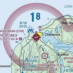
|
CAUTION: Diagram may not be current

| Airport distance calculator |
|---|
|
|
| Sunrise and sunset |
|---|
|
Times for 18-Apr-2026
| | Local
(UTC-4) | | Zulu
(UTC) |
|---|
| Morning civil twilight | | 06:21 | | 10:21 |
| Sunrise | | 06:52 | | 10:52 |
| Sunset | | 20:29 | | 00:29 |
| Evening civil twilight | | 21:00 | | 01:00 |
|
| Current date and time |
|---|
| Zulu (UTC) | 18-Apr-2026 10:23:48 |
|---|
| Local (UTC-4) | 18-Apr-2026 06:23:48 |
|---|
|
| METAR |
|---|
| KCVX | 180955Z AUTO 21010G15KT 4SM -RA BR OVC013 16/15 A2943 RMK AO2
|
KMGN
17nm NE | 180955Z AUTO 20008KT 10SM BKN013 OVC020 14/13 A2943 RMK AO2 T01450141
|
KBFA
17nm SE | 180955Z AUTO 19011KT 10SM OVC014 16/16 A2944 RMK AO2
|
KACB
20nm S | 180955Z AUTO 20007KT 10SM OVC012 16/15 A2946 RMK AO2 T01550145
|
|
| TAF |
|---|
KPLN
25nm NE | 180520Z 1806/1906 18011G19KT 6SM -SHRA BR OVC070 WS020/20035KT FM180900 18010G21KT 6SM -SHRA BR OVC029 FM181100 27011G21KT 4SM SHRA BR OVC008 FM181400 30012G22KT 6SM -SHRA BR OVC010 FM181800 28013G21KT P6SM BKN024
|
|
| NOTAMs |
|---|
NOTAMs are issued by the DoD/FAA and will open in a separate window not controlled by AirNav.
|
|


