FAA INFORMATION EFFECTIVE 02 OCTOBER 2025
Location
| FAA Identifier: | JKL |
| Lat/Long: | 37-35-37.9000N 083-19-02.1000W
37-35.631667N 083-19.035000W
37.5938611,-83.3172500
(estimated) |
| Elevation: | 1380.9 ft. / 420.9 m (surveyed) |
| Variation: | 04W (1985) |
| From city: | 3 miles NE of JACKSON, KY |
| Time zone: | UTC -4 (UTC -5 during Standard Time) |
| Zip code: | 41339 |
Airport Operations
| Airport use: | Open to the public |
| Activation date: | 04/1980 |
| Control tower: | no |
| ARTCC: | INDIANAPOLIS CENTER |
| FSS: | LOUISVILLE FLIGHT SERVICE STATION |
| NOTAMs facility: | JKL (NOTAM-D service available) |
| Attendance: | UNATNDD |
| Wind indicator: | yes |
| Segmented circle: | yes |
| Lights: | ACTVT MIRL RY 01/19 & REILS RYS 0/19 - CTAF. |
| Beacon: | white-green (lighted land airport)
Operates sunset to sunrise. |
Airport Communications
| CTAF/UNICOM: | 122.8 |
| WX ASOS: | 118.375 (606-252-3918) |
| WX AWOS-3 at CPF (13 nm S): | 119.025 (606-435-2452) |
- APCH/DEP SVC PRVDD BY INDIANAPOLIS ARTCC ON FREQS 126.575/257.85 (BLUEFIELD RCAG).
Nearby radio navigation aids
| NDB name | | Hdg/Dist | | Freq | | Var | | ID |
|---|
| SECO | | 109/35.3 | | 393 | | 03W | | XYC | -..- -.-- -.-. |
Airport Services
| Parking: | tiedowns |
| Airframe service: | NONE |
| Powerplant service: | NONE |
| Bottled oxygen: | NONE |
| Bulk oxygen: | NONE |
Runway Information
Runway 1/19
| Dimensions: | 4400 x 75 ft. / 1341 x 23 m |
| Surface: | asphalt, in fair condition |
| Weight bearing capacity: | |
| Runway edge lights: | medium intensity |
| Runway edge markings: | MARKINGS FADED AND ALGAE COVERED |
| RUNWAY 1 | | RUNWAY 19 |
| Latitude: | 37-35.272485N | | 37-35.990595N |
| Longitude: | 083-19.097160W | | 083-18.971637W |
| Elevation: | 1352.9 ft. | | 1380.9 ft. |
| Traffic pattern: | left | | left |
| Runway heading: | 012 magnetic, 008 true | | 192 magnetic, 188 true |
| Markings: | nonprecision, in poor condition | | nonprecision, in poor condition |
| Runway end identifier lights: | yes | | yes |
| Touchdown point: | yes, no lights | | yes, no lights |
| Obstructions: | 22 ft. trees, 206 ft. from runway, 102 ft. left of centerline, 1:1 slope to clear
TREES AND BRUSH LOCATED WITHIN 200' OF THE THRESHOLD LEFT OF THE APPROACH | | 14 ft. trees, 202 ft. from runway, 95 ft. right of centerline, 1:1 slope to clear
TREES AND BRUSH LOCATED WITHIN 200' OF THE THRESHOLD RIGHT OF THE APPROACH |
Airport Ownership and Management from official FAA records
| Ownership: | Publicly-owned |
| Owner: | JACKSON-BREATHITT COUNTY
208 AIRPORT ROAD
JACKSON, KY 41339
Phone (606) 666-3800 |
| Manager: | JOHNNY DEATON
208 AIRPORT ROAD
JACKSON, KY 41339
Phone (606) 568-5356
AIRPORT ADDRESS 1333 AIRPORT ROAD, JACKSON KY 41339 |
Additional Remarks
| - | FOR CD CTC INDIANAPOLIS ARTCC AT 317-247-2411. |
Instrument Procedures
NOTE: All procedures below are presented as PDF files. If you need a reader for these files, you should download the free Adobe Reader.NOT FOR NAVIGATION. Please procure official charts for flight.
FAA instrument procedures published for use from 02 October 2025 at 0901Z to 30 October 2025 at 0900z.
IAPs - Instrument Approach Procedures |
|---|
| RNAV (GPS) RWY 01 **CHANGED** | |
download (196KB) |
| NOTE: Special Alternate Minimums apply | |
download (159KB) |
| NOTE: Special Take-Off Minimums/Departure Procedures apply | |
download (228KB) |
Other nearby airports with instrument procedures:
KCPF - Wendell H Ford Airport (13 nm S)
KSJS - Big Sandy Regional Airport (34 nm E)
KPBX - Pike County Airport-Hatcher Field (36 nm E)
KSYM - Morehead-Rowan County Clyde A Thomas Regional Airport (39 nm N)
KIOB - Mount Sterling/Montgomery County Airport (42 nm NW)
|
|

Road maps at:
MapQuest
Bing
Google
| Aerial photo |
|---|
WARNING: Photo may not be current or correct
 Taken in 2005
Do you have a better or more recent aerial photo of Julian Carroll Airport that you would like to share? If so, please send us your photo.
|
| Sectional chart |
|---|
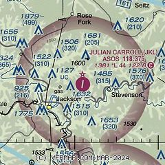
|
| Airport distance calculator |
|---|
|
|
| Sunrise and sunset |
|---|
|
Times for 14-Oct-2025
| | Local
(UTC-4) | | Zulu
(UTC) |
|---|
| Morning civil twilight | | 07:15 | | 11:15 |
| Sunrise | | 07:42 | | 11:42 |
| Sunset | | 18:57 | | 22:57 |
| Evening civil twilight | | 19:23 | | 23:23 |
|
| Current date and time |
|---|
| Zulu (UTC) | 14-Oct-2025 10:15:49 |
|---|
| Local (UTC-4) | 14-Oct-2025 06:15:49 |
|---|
|
| METAR |
|---|
| KJKL | 140953Z AUTO 00000KT 10SM CLR 13/08 A3016 RMK AO2 SLP205 T01280083
|
KCPF
13nm S | 140955Z AUTO 00000KT 10SM CLR 08/08 A3016 RMK AO2
|
|
| TAF |
|---|
| KJKL | 140525Z 1406/1506 00000KT P6SM SKC FM141500 03007KT P6SM FEW120 FM142300 00000KT P6SM FEW200
|
|
| NOTAMs |
|---|
NOTAMs are issued by the DoD/FAA and will open in a separate window not controlled by AirNav.
|
|

