FAA INFORMATION EFFECTIVE 19 MARCH 2026
Location
| FAA Identifier: | PKD |
| Lat/Long: | 46-54-04.3337N 095-04-23.1825W
46-54.072228N 095-04.386375W
46.9012038,-95.0731062
(estimated) |
| Elevation: | 1444.5 ft. / 440.3 m (surveyed) |
| Variation: | 04E (1995) |
| From city: | 2 miles S of PARK RAPIDS, MN |
| Time zone: | UTC -5 (UTC -6 during Standard Time) |
| Zip code: | 56470 |
Airport Operations
| Airport use: | Open to the public |
| Control tower: | no |
| ARTCC: | MINNEAPOLIS CENTER |
| FSS: | PRINCETON FLIGHT SERVICE STATION |
| NOTAMs facility: | PKD (NOTAM-D service available) |
| Attendance: | MON-FRI 0800-1700
FOR SVC AFT HRS CALL 218-237-8528. |
| Wind indicator: | lighted |
| Segmented circle: | yes |
| Lights: | ACTVT OR INCR INTST MALSR RWY 31; REIL RWY 13, 18, & 36; PAPI RWY 13, 31, 18, & 36; HIRL RWY 13/31; MIRL RWY 18/36 - CTAF. HIRL RWY 13/31 PRESET LOW INTST SS-SR. |
| Beacon: | white-green (lighted land airport)
Operates sunset to sunrise. |
Airport Communications
| CTAF/UNICOM: | 123.0 |
| WX ASOS: | 119.25 (218-732-0920) |
- APCH/DEP SVC PRVDD BY MINNEAPOLIS ARTCC (ZMP) ON FREQ 134.75/251.1 (BEMIDJI RCAG).
Nearby radio navigation aids
| VOR radial/distance | | VOR name | | Freq | | Var |
|---|
| DTLr080/33.7 | | DETROIT LAKES VOR/DME | | 111.20 | | 02E |
| IDJr189/36.9 | | LAKE BEMIDJI VOR/DME | | 110.00 | | 01E |
| NDB name | | Hdg/Dist | | Freq | | Var | | ID |
|---|
| SPIDA | | 311/5.7 | | 269 | | 04E | | PK | .--. -.- |
Airport Services
| Fuel available: | 100LL
100LL:100LL AVBL H24 VIA CREDIT CARD. |
| Parking: | hangars and tiedowns |
| Airframe service: | MAJOR |
| Powerplant service: | MAJOR |
| Bottled oxygen: | NONE |
| Bulk oxygen: | NONE |
Runway Information
Runway 13/31
| Dimensions: | 5497 x 100 ft. / 1675 x 30 m |
| Surface: | asphalt, in fair condition |
| Weight bearing capacity: | | Single wheel: | 20.0 | | Double wheel: | 36.0 |
|
| Runway edge lights: | high intensity |
| RUNWAY 13 | | RUNWAY 31 |
| Latitude: | 46-54.403203N | | 46-53.763062N |
| Longitude: | 095-04.866742W | | 095-03.934900W |
| Elevation: | 1444.5 ft. | | 1443.0 ft. |
| Traffic pattern: | left | | left |
| Runway heading: | 131 magnetic, 135 true | | 311 magnetic, 315 true |
| Markings: | precision, in fair condition | | precision, in fair condition |
| Visual slope indicator: | 4-light PAPI on left (3.00 degrees glide path) | | 4-light PAPI on left (3.00 degrees glide path) |
| Approach lights: | | | MALSR: 1,400 foot medium intensity approach lighting system with runway alignment indicator lights |
| Runway end identifier lights: | yes | | |
| Touchdown point: | yes, no lights | | yes, no lights |
| Instrument approach: | | | ILS |
Runway 18/36
| Dimensions: | 3500 x 75 ft. / 1067 x 23 m |
| Surface: | asphalt, in good condition |
| Runway edge lights: | medium intensity |
| RUNWAY 18 | | RUNWAY 36 |
| Latitude: | 46-54.342960N | | 46-53.767247N |
| Longitude: | 095-04.363768W | | 095-04.363607W |
| Elevation: | 1440.9 ft. | | 1442.4 ft. |
| Traffic pattern: | left | | left |
| Runway heading: | 176 magnetic, 180 true | | 356 magnetic, 360 true |
| Markings: | basic, in good condition | | basic, in good condition |
| Visual slope indicator: | 4-light PAPI on left (3.00 degrees glide path) | | 4-light PAPI on right (3.00 degrees glide path) |
| Runway end identifier lights: | yes | | yes |
| Touchdown point: | yes, no lights | | yes, no lights |
Airport Ownership and Management from official FAA records
| Ownership: | Publicly-owned |
| Owner: | CITY OF PARK RAPIDS
212 2ND ST W
PARK RAPIDS, MN 56470-1507
Phone 218-732-3163 |
| Manager: | SCOTT BURLINGAME
212 2ND ST W
PARK RAPIDS, MN 56470-1507
Phone 218-237-2713 |
Instrument Procedures
NOTE: All procedures below are presented as PDF files. If you need a reader for these files, you should download the free Adobe Reader.NOT FOR NAVIGATION. Please procure official charts for flight.
FAA instrument procedures published for use from 19 March 2026 at 0901Z to 16 April 2026 at 0900Z.
IAPs - Instrument Approach Procedures |
|---|
| ILS OR LOC RWY 31 | |
download (240KB) |
| RNAV (GPS) RWY 13 | |
download (223KB) |
| RNAV (GPS) RWY 31 | |
download (237KB) |
| NOTE: Special Alternate Minimums apply | |
download (153KB) |
| NOTE: Special Take-Off Minimums/Departure Procedures apply | |
download (405KB) |
Other nearby airports with instrument procedures:
Y49 - Walker Municipal Airport (23 nm NE)
KADC - Wadena Municipal Airport (28 nm S)
16D - Perham Municipal Airport (28 nm SW)
KPWC - Pine River Regional Airport (30 nm E)
KSAZ - Staples Municipal Airport (33 nm S)
|
|

Road maps at:
MapQuest
Bing
Google
| Aerial photo |
|---|
WARNING: Photo may not be current or correct
 Photo by Vicki Eifert
Photo taken 29-May-2018
looking southeast.
Photo by Vicki Eifert
Photo taken 29-May-2018
looking southeast.
Do you have a better or more recent aerial photo of Park Rapids Municipal Airport-Konshok Field that you would like to share? If so, please send us your photo.
|
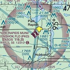
| Sectional chart |
|---|
|
| Airport distance calculator |
|---|
|
|
| Sunrise and sunset |
|---|
|
Times for 09-Apr-2026
| | Local
(UTC-5) | | Zulu
(UTC) |
|---|
| Morning civil twilight | | 06:14 | | 11:14 |
| Sunrise | | 06:45 | | 11:45 |
| Sunset | | 19:59 | | 00:59 |
| Evening civil twilight | | 20:30 | | 01:30 |
|
| Current date and time |
|---|
| Zulu (UTC) | 09-Apr-2026 09:31:55 |
|---|
| Local (UTC-5) | 09-Apr-2026 04:31:55 |
|---|
|
| METAR |
|---|
| KPKD | 090853Z AUTO 30014G21KT 10SM OVC008 M01/M02 A2994 RMK AO2 SLP153 60000 T10061022 53026
|
|
| TAF |
|---|
KBJI
36nm N | 090520Z 0906/1006 29010KT P6SM BKN010 TEMPO 0906/0910 OVC008 FM092100 29005KT P6SM BKN030
|
|
| NOTAMs |
|---|
NOTAMs are issued by the DoD/FAA and will open in a separate window not controlled by AirNav.
|
|

