FAA INFORMATION EFFECTIVE 15 MAY 2025
Location
| FAA Identifier: | M71 |
| Lat/Long: | 38-54-06.3900N 090-57-37.1000W
38-54.106500N 090-57.618333W
38.9017750,-90.9603056
(estimated) |
| Elevation: | 559 ft. / 170 m (estimated) |
| Variation: | 02E (1985) |
| From city: | 4 miles SW of MOSCOW MILLS, MO |
| Time zone: | UTC -5 (UTC -6 during Standard Time) |
| Zip code: | 63379 |
Airport Operations
| Airport use: | Open to the public |
| Activation date: | 03/1991 |
| Control tower: | no |
| ARTCC: | KANSAS CITY CENTER |
| FSS: | SAINT LOUIS FLIGHT SERVICE STATION |
| NOTAMs facility: | STL (NOTAM-D service available) |
| Attendance: | UNATNDD |
| Wind indicator: | yes |
| Segmented circle: | no |
Airport Communications
| CTAF: | 122.9 |
| WX AWOS-3PT at FYG (19 nm S): | 121.325 (636-433-5914) |
Nearby radio navigation aids
| VOR radial/distance | | VOR name | | Freq | | Var |
|---|
| FTZr357/12.5 | | FORISTELL VORTAC | | 110.80 | | 05E |
| STLr275/22.5 | | ST LOUIS VORTAC | | 117.40 | | 01E |
Airport Services
Runway Information
Runway 9/27
| Dimensions: | 3227 x 50 ft. / 984 x 15 m |
| Surface: | asphalt/aggregate friction seal coat, in good condition |
| RUNWAY 9 | | RUNWAY 27 |
| Latitude: | 38-54.115000N | | 38-54.098000N |
| Longitude: | 090-57.960000W | | 090-57.279000W |
| Elevation: | 529.0 ft. | | 559.0 ft. |
| Traffic pattern: | left | | left |
| Markings: | basic, in good condition | | basic, in good condition |
| Obstructions: | 33 ft. trees, 308 ft. from runway, 120 ft. right of centerline, 3:1 slope to clear
POWERLINES 125 FT R AND L, 170 FT FM RWY END; +1-35 FT TREES, 118-200 FT FM RWY END, 70-125 FT R. | | 35 ft. trees, 850 ft. from runway, 136 ft. left of centerline, 18:1 slope to clear
+1-6 FT GND & BRUSH, 0-200 FT FM RY END, 100-145 FT L. |
Airport Ownership and Management from official FAA records
| Ownership: | Privately-owned |
| Owner: | RICHARD GREEN
55 NORTH POINTE CIR.
LAKE ST. LOUIS, MO 63367
Phone 314-650-5804 |
| Manager: | RICHARD GREEN
2166 MYERS ROAD
TROY, MO 63379
Phone 314-650-5804
AIRPORT PHYSICAL ADDRESS. |
Additional Remarks
| - | NTSD RY SAFETY AREA BYND EACH RY END & ALONG RY EDGES; RW 09 END HAS LARGE DROP-OFF; RY 27 INCORRECT TERRAIN GRADES WITH BRUSH & TREES; BRUSH, SMALL TREES, EXCESSIVE EDGE DROPS & DITCHES ALONG PVMT EDGES. |
| - | HIGH GND, BRUSH, TREES, AND BLDGS PENETRATE PRIMARY AND TRANSITIONAL SURFACES & CLOSE TO RY EDGES. |
| - | WILDLIFE ON & INVOF ARPT. |
| - | FOR CD CTC ST LOUIS APCH AT 314-890-1017. |
Instrument Procedures
There are no published instrument procedures at M71.
Some nearby airports with instrument procedures:
KFYG - Washington Regional Airport (19 nm S)
KSUS - Spirit of St Louis Airport (20 nm SE)
1H0 - Creve Coeur Airport (24 nm SE)
KSET - St Charles County Regional Airport/Smartt Field (25 nm E)
KSTL - St Louis Lambert International Airport (29 nm E)
|
|

Road maps at:
MapQuest
Bing
Google
| Aerial photo |
|---|
WARNING: Photo may not be current or correct
 Photo taken by Dave and Tammy Zilz 10-10-04
Do you have a better or more recent aerial photo of Greensfield Airport that you would like to share? If so, please send us your photo.
|
| Sectional chart |
|---|
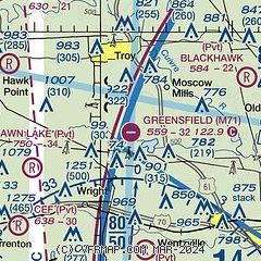
|
| Airport distance calculator |
|---|
|
|
| Sunrise and sunset |
|---|
|
Times for 29-May-2025
| | Local
(UTC-5) | | Zulu
(UTC) |
|---|
| Morning civil twilight | | 05:11 | | 10:11 |
| Sunrise | | 05:43 | | 10:43 |
| Sunset | | 20:20 | | 01:20 |
| Evening civil twilight | | 20:51 | | 01:51 |
|
| Current date and time |
|---|
| Zulu (UTC) | 29-May-2025 09:52:03 |
|---|
| Local (UTC-5) | 29-May-2025 04:52:03 |
|---|
|
| METAR |
|---|
KSUS
21nm SE | 290903Z AUTO 00000KT 3SM BR CLR 12/12 A3006 RMK AO2 T01220117
|
KSET
25nm E | 290854Z AUTO 00000KT 6SM BR FEW110 13/12 A3006 RMK AO2 SLP177 T01330122 55001
|
KSTL
29nm E | 290851Z 23003KT 10SM CLR 15/12 A3008 RMK AO2 SLP178 T01500117 55003
|
|
| TAF |
|---|
KSUS
21nm SE | 290520Z 2906/3006 VRB04KT P6SM SCT060 FM291600 VRB03KT 6SM -RA BKN035 FM291900 VRB04KT 5SM -RA OVC017 FM300200 VRB04KT P6SM OVC021
|
|
| NOTAMs |
|---|
NOTAMs are issued by the DoD/FAA and will open in a separate window not controlled by AirNav.
|
|


