FAA INFORMATION EFFECTIVE 04 SEPTEMBER 2025
Location
| FAA Identifier: | STL |
| Lat/Long: | 38-44-55.3136N 090-22-12.0926W
38-44.921893N 090-22.201543W
38.7486982,-90.3700257
(estimated) |
| Elevation: | 617.3 ft. / 188.2 m (surveyed) |
| Variation: | 01W (2020) |
| From city: | 10 miles NW of ST LOUIS, MO |
| Time zone: | UTC -5 (UTC -6 during Standard Time) |
| Zip code: | 63134 |
Airport Operations
| Airport use: | Open to the public |
| Activation date: | 04/1940 |
| Control tower: | yes |
| ARTCC: | KANSAS CITY CENTER |
| FSS: | SAINT LOUIS FLIGHT SERVICE STATION |
| NOTAMs facility: | STL (NOTAM-D service available) |
| Attendance: | CONTINUOUS |
| Wind indicator: | lighted |
| Segmented circle: | no |
| Beacon: | white-green (lighted land airport)
Operates sunset to sunrise. |
| Landing fee: | yes, LNDG FEE BASED ON ACFT WEIGHT COLLECTED BY FBO. |
| Fire and rescue: | ARFF index D |
| International operations: | customs landing rights airport |
Airport Communications
| UNICOM: | 122.95 |
| WX ASOS: | PHONE 314-238-8419 |
| SAINT LOUIS GROUND: | 118.925 ;RWY 11/29 121.075 ;WEST 121.65 ;OUTBOUND 121.9 ;INBOUND 127.55 ;EAST 227.125 ;RWY 11/29 346.35 ;WEST 348.6 ;INBOUND 360.2 ;EAST 377.175 ;OUTBOUND |
| SAINT LOUIS TOWER: | 118.5 ;RWY 12R/30L 120.05 ;RWY 12L/30R, 24 132.475 ;RWY 06, 11/29 239.275 ;RWY 06, 11/29 257.7 ;RWY 12R/30L 284.6 ;RWY 12L/30R, 24 |
| SAINT LOUIS APPROACH: | 132.125 121.025 ;S/W 123.7 |
| SAINT LOUIS DEPARTURE: | 119.15 ;N/E 128.1 ;S/W |
| CLEARANCE DELIVERY: | 119.5 363.1 |
| BERYY DP: | 128.1 |
| BGOOD DP: | 128.1 |
| BLUES DP: | 119.15 |
| BRAKK DP: | 128.1 |
| CARDS DP: | 119.15 |
| CHUUC DP: | 128.1 |
| CLASS B: | 124.2 ;N/E 126.5 ;S/W |
| D-ATIS: | 125.025 379.925 |
| DRUSE DP: | 128.1 |
| EEMOS DP: | 119.15 |
| EMERG: | 121.5 243.0 |
| GATWY DP: | 119.15 |
| JAHNY DP: | 128.1 |
| JHART DP: | 119.15 |
| KSHEE DP: | 119.15 |
| LINDY DP: | 128.1 |
| METERING: | 121.075 ;WEST 127.55 ;EAST 346.35 ;WEST 360.2 ;EAST |
| NATCA DP: | 119.15 |
| OZARK DP: | 128.1 |
| PLESS DP: | 128.1 |
| PRM: | 278.3 ;RWY 30R 351.9 ;RWY 30L |
| ROTRY DP: | 119.15 |
| TEDDD DP: | 119.15 |
| TURBO DP: | 119.15 ;AXC TRANSITION 128.1 |
| WHRLI DP: | 128.1 |
| WX ASOS at SET (11 nm N): | 118.075 (636-250-4590) |
| WX ASOS at SUS (14 nm W): | 134.8 (314-890-7255) |
| WX ASOS at CPS (15 nm SE): | PHONE 618-332-0001 |
| WX AWOS-3 at ALN (17 nm NE): | 128.0 (618-259-7231) |
- ASDE-X IN USE. OPERATE TRANSPONDERS WITH ALTITUDE REPORTING MODE AND ADS-B (IF EQUIPPED) ENABLED ON ALL AIRPORT SURFACES.
Nearby radio navigation aids
| VOR radial/distance | | VOR name | | Freq | | Var |
|---|
| STLr141/8.5 | | ST LOUIS VORTAC | | 117.40 | | 01E |
| TOYr268/21.1 | | TROY VORTAC | | 116.00 | | 04E |
| FTZr078/28.3 | | FORISTELL VORTAC | | 110.80 | | 05E |
| NDB name | | Hdg/Dist | | Freq | | Var | | ID |
|---|
| EAVES | | 064/9.3 | | 227 | | 01W | | FZ | ..-. --.. |
Airport Services
| Fuel available: | 100LL JET-A
A:JET-A |
| Parking: | hangars and tiedowns |
| Airframe service: | MAJOR |
| Powerplant service: | MAJOR |
| Bottled oxygen: | HIGH/LOW |
| Bulk oxygen: | HIGH/LOW |
Runway Information
Runway 12R/30L
| Dimensions: | 11020 x 150 ft. / 3359 x 46 m |
| Surface: | concrete/grooved, in good condition |
| Weight bearing capacity: | | PCN 85 /R/B/W/T | | Single wheel: | 75.0, RUNWAY LOAD CAPACITY: ST175 | | Double wheel: | 200.0 | | Double tandem: | 350.0 | | Dual double tandem: | 760.0 |
|
| Runway edge lights: | high intensity |
| RUNWAY 12R | | RUNWAY 30L |
| Latitude: | 38-45.234232N | | 38-44.266908N |
| Longitude: | 090-22.749532W | | 090-20.787867W |
| Elevation: | 541.3 ft. | | 585.3 ft. |
| Traffic pattern: | right | | left |
| Runway heading: | 123 magnetic, 122 true | | 303 magnetic, 302 true |
| Displaced threshold: | 468 ft. | | 201 ft. |
| Declared distances: | TORA:11020 TODA:11020 ASDA:11020 LDA:10553 | | TORA:11020 TODA:11020 ASDA:10880 LDA:10679 |
| Markings: | precision, in good condition | | precision, in good condition |
| Visual slope indicator: | 4-light PAPI on left (3.00 degrees glide path) | | 4-light PAPI on right (3.00 degrees glide path) |
| RVR equipment: | touchdown, rollout | | touchdown, rollout |
| Approach lights: | MALSR: 1,400 foot medium intensity approach lighting system with runway alignment indicator lights | | MALSR: 1,400 foot medium intensity approach lighting system with runway alignment indicator lights |
| Runway end identifier lights: | | | no |
| Centerline lights: | yes | | yes |
| Touchdown point: | yes, lighted | | yes, no lights |
| Instrument approach: | ILS/DME | | ILS |
| Obstructions: | 119 ft. tree, 3213 ft. from runway, 773 ft. left of centerline, 27:1 slope to clear
APCH RATIO FM DSPLCD THR 25:1. | | 99 ft. tree, 2895 ft. from runway, 547 ft. right of centerline, 29:1 slope to clear
APCH RATIO FM DSPLCD THR 34:1. |
Runway 12L/30R
| Dimensions: | 9013 x 150 ft. / 2747 x 46 m |
| Surface: | concrete/grooved, in good condition |
| Weight bearing capacity: | | PCN 85 /R/B/W/T | | Single wheel: | 75.0, RUNWAY LOAD CAPACITY: ST175 | | Double wheel: | 200.0 | | Double tandem: | 350.0 | | Dual double tandem: | 760.0 |
|
| Runway edge lights: | high intensity |
| RUNWAY 12L | | RUNWAY 30R |
| Latitude: | 38-45.107598N | | 38-44.316432N |
| Longitude: | 090-21.979303W | | 090-20.375128W |
| Elevation: | 527.7 ft. | | 604.3 ft. |
| Traffic pattern: | left | | right |
| Runway heading: | 123 magnetic, 122 true | | 303 magnetic, 302 true |
| Declared distances: | TORA:9013 TODA:9013 ASDA:8956 LDA:8956 | | TORA:9013 TODA:9013 ASDA:9013 LDA:9013 |
| Markings: | precision, in good condition | | precision, in good condition |
| Visual slope indicator: | 4-light PAPI on right (3.00 degrees glide path) | | 4-light PAPI on right (3.00 degrees glide path) |
| RVR equipment: | touchdown, midfield, rollout | | touchdown, midfield, rollout |
| Approach lights: | ALSF2: standard 2,400 foot high intensity approach lighting system with centerline sequenced flashers (category II or III) | | ALSF2: standard 2,400 foot high intensity approach lighting system with centerline sequenced flashers (category II or III) |
| Runway end identifier lights: | no | | |
| Centerline lights: | yes | | yes |
| Touchdown point: | yes, lighted | | yes, lighted |
| Instrument approach: | ILS/DME | | ILS/DME |
| Obstructions: | 132 ft. tree, 4870 ft. from runway, 408 ft. left of centerline, 37:1 slope to clear | | 52 ft. tree, 1732 ft. from runway, 612 ft. left of centerline, 33:1 slope to clear |
Runway 11/29
| Dimensions: | 9000 x 150 ft. / 2743 x 46 m |
| Surface: | concrete/grooved, in excellent condition |
| Weight bearing capacity: | | PCN 85 /R/B/W/T | | Single wheel: | 75.0 | | Double wheel: | 200.0 | | Double tandem: | 325.0 | | Dual double tandem: | 700.0 |
|
| Runway edge lights: | high intensity |
| RUNWAY 11 | | RUNWAY 29 |
| Latitude: | 38-45.597137N | | 38-44.807535N |
| Longitude: | 090-24.592338W | | 090-22.989757W |
| Elevation: | 616.8 ft. | | 555.2 ft. |
| Traffic pattern: | right | | left |
| Runway heading: | 123 magnetic, 122 true | | 303 magnetic, 302 true |
| Declared distances: | TORA:9000 TODA:9000 ASDA:9000 LDA:9000 | | TORA:9000 TODA:9000 ASDA:9000 LDA:9000 |
| Markings: | precision, in good condition | | precision, in good condition |
| Visual slope indicator: | 4-light PAPI on right (3.00 degrees glide path) | | 4-light PAPI on left (3.00 degrees glide path) |
| RVR equipment: | touchdown, midfield, rollout | | touchdown, midfield, rollout |
| Approach lights: | ALSF2: standard 2,400 foot high intensity approach lighting system with centerline sequenced flashers (category II or III) | | ALSF2: standard 2,400 foot high intensity approach lighting system with centerline sequenced flashers (category II or III) |
| Centerline lights: | yes | | yes |
| Touchdown point: | yes, lighted | | yes, lighted |
| Instrument approach: | ILS/DME | | ILS/DME |
| Obstructions: | none | | 121 ft. tree, 3218 ft. from runway, 860 ft. left of centerline, 25:1 slope to clear |
Runway 6/24
| Dimensions: | 7603 x 150 ft. / 2317 x 46 m |
| Surface: | concrete/grooved, in fair condition |
| Weight bearing capacity: | | PCN 85 /R/B/W/T | | Single wheel: | 75.0 | | Double wheel: | 176.0, RUNWAY LOAD CAPACITY: ST175 | | Double tandem: | 280.0 | | Dual double tandem: | 660.0 |
|
| Runway edge lights: | high intensity |
| RUNWAY 6 | | RUNWAY 24 |
| Latitude: | 38-44.801035N | | 38-45.373048N |
| Longitude: | 090-22.873057W | | 090-21.450233W |
| Elevation: | 550.6 ft. | | 533.2 ft. |
| Traffic pattern: | left | | left |
| Runway heading: | 064 magnetic, 063 true | | 244 magnetic, 243 true |
| Declared distances: | TORA:7603 TODA:7603 ASDA:7323 LDA:7323 | | TORA:7603 TODA:7603 ASDA:7603 LDA:7603 |
| Markings: | precision, in good condition | | precision, in good condition |
| Visual slope indicator: | 4-light PAPI on right (3.00 degrees glide path) | | 4-light PAPI on left (3.00 degrees glide path) |
| RVR equipment: | touchdown, rollout | | touchdown, rollout |
| Approach lights: | MALSR: 1,400 foot medium intensity approach lighting system with runway alignment indicator lights | | MALS: 1,400 foot medium intensity approach lighting system |
| Touchdown point: | yes, no lights | | yes, no lights |
| Instrument approach: | ILS/DME | | ILS/DME |
| Obstructions: | 110 ft. tree, 3077 ft. from runway, 505 ft. right of centerline, 27:1 slope to clear | | 18 ft. sign, 750 ft. from runway, 450 ft. right of centerline, 30:1 slope to clear |
Airport Ownership and Management from official FAA records
| Ownership: | Publicly-owned |
| Owner: | CITY OF ST LOUIS
1200 MARKET STREET
ST LOUIS, MO 63103
Phone 314-622-4800
CITY HALL |
| Manager: | MS. RHONDA HAMM-NIEBRUEGGE
BOX 10212
ST LOUIS, MO 63145
Phone 314-426-8000
DELIVERIES GOTO: 10701 LAMBERT INTERNATIONAL BLVD. |
Additional Remarks
| E60-30L | BAK-14 BAK -12B(B) (1300') |
| E60-12R | BAK-14 BAK -12B(B) (1090') |
| E60-06 | BAK-14 BAK -12B(B) (1450') |
| - | WAIVER TO CONDUCT SIMUL APCHS TO PARL RYS SEPARATED BY 1,300 FT IN EFCT. |
| - | WG TIP CLNC WITH GND VEH NOT ADQT ALG N SIDE OF MAIN TRML APN. |
| - | A-GEAR: A-G ARE KEPT IN RECESSED POSN TIL REQ FOR USE. TWR MUST BE NOTIFIED AT LEAST 5 SEC PRIOR TO ENGAGEMENT SO THAT CABLE MAY BE RAISED. |
| - | TWY DELTA OR TAXILANE CHARLIE FM TWY SIERRA TO TWY GOLF, B-747S ARE NOT AUTH TO PASS OR BE PASSED BY B767 OR OTR LRGR ACFT OPRG ON THE PARL TWY/TAXILANE. |
| - | TWY NOVEMBER BTN RWY 24 AND FOXTROT, RSTRD TO ACFT WITH A WINGSPAN OF LESS THAN 79 FT (CRJ-900 OR SMLR) WHEN ACFT ARE PARKED ON THE NOVEMBER PAD. THIS AREA IS RSTRD TO ALL OPNS WHEN ACFT ARE PERFORMING END RUN-UPS IN THE NOVEMBER PAD. |
| - | TWY VICTOR, UNDERLYING THE RWY 12L FNA CRS, IS RSTRD TO ACFT WITH A TAIL HGT OF 25 FT OR LESS (CRJ-700 OR SMLR) WHEN ACFT ARE LNDG ON RWY 12L. |
| - | TWY CHARLIE, EAST OF TWY DELTA ONE TO THE AER 30L, RSTRD TO B-737 OR SMLR ACFT (WINGSPAN LESS THAN 118 FT) WHEN ACFT ARE PARKED ON THE HOTEL PAD. |
| - | TWY CHARLIE, FROM TWY CHARLIE SIX TO TWY DELTA FOUR, RSTRD TO B757-300 SERIES OR SMLR WHEN PASSING BHND ACFT THAT HAVE MADE THE INITIAL 10 FT PUSHBACK. |
| - | TWY ALPHA EAST OF TWY TANGO, TWY SIERRA AND RWY 6/24 SOUTH OF TWY BRAVO, NO ACFT OR VEHICLE OPNS WHEN ARRIVING OR DEPG RWY 11 OR ARRIVING RWY 29. |
| - | TWY LIMA, NORTH OF RWY 12L/30R, ACFT LRGR THAN A GULFSTREAM VI TAX NBND ARE PROHIBITED FM MAKING A RIGHT TURN EBND ON TWY FOXTROT. |
| - | TWY VICTOR 2 IS UNAVBL TO B-767 OR LRGR ACFT (WINGSPAN 118 FT OR GTR). |
| - | TWY VICTOR 2, B-737 (WINGSPAN GTR THAN 79 FT BUT LESS THAN 118 FT) MUST PERFORM JUDGMENTAL OVERSTEERING INSTEAD OF COCKPIT OVR CNTRLN STEERING WHEN TAX. |
| - | TWY KILO 1 IS UNAVBL TO B-767 OR LRGR ACFT (WINGSPAN 118 FT OR GTR). |
| - | TWY ECHO, BTN TWY NOVEMBER AND TWY LIMA RSTRD TO B-767 OR SMLR ACFT (WINGSPAN LESS THAN 171 FT) WHEN ACFT ARE PARKED ON THE ECHO PAD. |
| - | TWY CHARLIE, FM TWY SIERRA TO TWY CHARLIE SEVEN, RSTRD TO B-767 OR SMLR ACFT (156 FT AVBL) WHEN ACFT ARE PARKED IN THE CHARLIE PAD. RSTRN IS FOR TAX ACFT, LRGR ACFT MAY BE TOWED THRU AREA. |
| - | TWY CHARLIE, FROM TWY CHARLIE SEVEN TO TWY CHARLIE SIX, RSTRD TO A B757-300 SERIES OR SMLR. |
Instrument Procedures
NOTE: All procedures below are presented as PDF files. If you need a reader for these files, you should download the free Adobe Reader.NOT FOR NAVIGATION. Please procure official charts for flight.
FAA instrument procedures published for use from 04 September 2025 at 0901Z to 02 October 2025 at 0900z.
STARs - Standard Terminal Arrivals |
|---|
| AARCH TWO (RNAV) | |
2 pages:
[1] [2] (398KB) |
| BOOSH THREE (RNAV) | |
2 pages:
[1] [2] (479KB) |
| KAYLA THREE (RNAV) | |
2 pages:
[1] [2] (402KB) |
| KOOOP ONE | |
download (207KB) |
| LORLE THREE (RNAV) | |
2 pages:
[1] [2] (409KB) |
IAPs - Instrument Approach Procedures |
|---|
| ILS OR LOC RWY 11 **CHANGED** | |
download (355KB) |
| ILS OR LOC RWY 12L **CHANGED** | |
download (386KB) |
| ILS OR LOC RWY 12R **CHANGED** | |
download (383KB) |
| ILS OR LOC RWY 24 **CHANGED** | |
download (315KB) |
| ILS OR LOC RWY 29 **CHANGED** | |
download (380KB) |
| ILS OR LOC RWY 30L **CHANGED** | |
download (353KB) |
| ILS OR LOC RWY 30R **CHANGED** | |
download (348KB) |
| ILS RWY 11 (CAT II - III) **CHANGED** | |
download (335KB) |
| ILS RWY 12L (CAT II - III) **CHANGED** | |
download (335KB) |
| ILS RWY 30R (CAT II - III) **CHANGED** | |
download (310KB) |
| RNAV (RNP) Z RWY 11 **CHANGED** | |
download (357KB) |
| RNAV (RNP) Z RWY 12L **CHANGED** | |
download (351KB) |
| RNAV (RNP) Z RWY 12R **CHANGED** | |
download (340KB) |
| RNAV (RNP) Z RWY 29 **CHANGED** | |
download (351KB) |
| RNAV (RNP) Z RWY 30L **CHANGED** | |
download (326KB) |
| RNAV (RNP) Z RWY 30R **CHANGED** | |
download (310KB) |
| RNAV (GPS) RWY 06 **CHANGED** | |
download (264KB) |
| RNAV (GPS) RWY 24 **CHANGED** | |
download (285KB) |
| RNAV (GPS) Y RWY 11 **CHANGED** | |
download (298KB) |
| RNAV (GPS) Y RWY 12L **CHANGED** | |
download (308KB) |
| RNAV (GPS) Y RWY 12R **CHANGED** | |
download (300KB) |
| RNAV (GPS) Y RWY 29 **CHANGED** | |
download (315KB) |
| RNAV (GPS) Y RWY 30L **CHANGED** | |
download (296KB) |
| RNAV (GPS) Y RWY 30R **CHANGED** | |
download (291KB) |
| LOC RWY 06 **NEW** | |
download (317KB) |
| TACAN RWY 12R | |
download (178KB) |
| TACAN RWY 30L | |
download (181KB) |
Departure Procedures |
|---|
| BERYY FIVE (RNAV) | |
2 pages:
[1] [2] (371KB) |
| BGOOD FIVE (RNAV) | |
2 pages:
[1] [2] (400KB) |
| BRAKK FIVE (RNAV) | |
2 pages:
[1] [2] (374KB) |
| CHUUC SIX (RNAV) | |
2 pages:
[1] [2] (393KB) |
| DRUSE FIVE (RNAV) | |
2 pages:
[1] [2] (396KB) |
| EEMOS FIVE (RNAV) | |
2 pages:
[1] [2] (352KB) |
| GATEWAY ONE | |
2 pages:
[1] [2] (449KB) |
| JAHNY SIX (RNAV) | |
2 pages:
[1] [2] (382KB) |
| JHART SEVEN (RNAV) | |
2 pages:
[1] [2] (425KB) |
| KSHEE FIVE (RNAV) | |
2 pages:
[1] [2] (351KB) |
| LINDBERGH EIGHT | |
2 pages:
[1] [2] (338KB) |
| NATCA FIVE (RNAV) | |
2 pages:
[1] [2] (350KB) |
| OZARK EIGHT | |
download (204KB) |
| PLESS FIVE | |
download (224KB) |
| ROTRY SIX (RNAV) **NEW** | |
2 pages:
[1] [2] (328KB) |
| TEDDD FIVE (RNAV) | |
2 pages:
[1] [2] (358KB) |
| WHRLI SEVEN (RNAV) | |
2 pages:
[1] [2] (378KB) |
| NOTE: Special Take-Off Minimums/Departure Procedures apply | |
download (431KB) |
Other nearby airports with instrument procedures:
1H0 - Creve Coeur Airport (7 nm W)
KSET - St Charles County Regional Airport/Smartt Field (11 nm N)
KSUS - Spirit of St Louis Airport (14 nm W)
KCPS - St Louis Downtown Airport (15 nm SE)
KALN - St Louis Regional Airport (17 nm NE)
|
|

Road maps at:
MapQuest
Bing
Google
| Aerial photo |
|---|
WARNING: Photo may not be current or correct
 Photo by Bob Srenco
Photo taken 12-Jul-2019
looking west-southwest.
Photo by Bob Srenco
Photo taken 12-Jul-2019
looking west-southwest.
Do you have a better or more recent aerial photo of St Louis Lambert International Airport that you would like to share? If so, please send us your photo.
|
| Sectional chart |
|---|
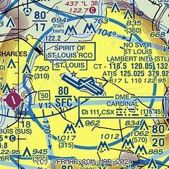
|
 Download PDF
of official airport diagram from the FAA
| Airport distance calculator |
|---|
|
|
| Sunrise and sunset |
|---|
|
Times for 29-Sep-2025
| | Local
(UTC-5) | | Zulu
(UTC) |
|---|
| Morning civil twilight | | 06:30 | | 11:30 |
| Sunrise | | 06:57 | | 11:57 |
| Sunset | | 18:47 | | 23:47 |
| Evening civil twilight | | 19:14 | | 00:14 |
|
| Current date and time |
|---|
| Zulu (UTC) | 29-Sep-2025 08:14:50 |
|---|
| Local (UTC-5) | 29-Sep-2025 03:14:50 |
|---|
|
| METAR |
|---|
| KSTL | 290751Z 00000KT 10SM CLR 18/14 A3017 RMK AO2 SLP206 T01780139 $
|
KSET
11nm N | 290754Z AUTO 00000KT 10SM CLR 15/14 A3016 RMK AO2 SLP208 T01500139
|
KSUS
14nm SW | 290754Z AUTO 00000KT 10SM CLR 13/13 A3016 RMK AO2 SLP206 T01330128
|
KCPS
15nm SE | 290753Z AUTO 00000KT 10SM CLR 14/13 A3016 RMK AO2 SLP209 T01390133 $
|
KALN
18nm NE | 290755Z 10SM CLR 14/13 A3017 RMK AO2 T01420132
|
|
| TAF |
|---|
| KSTL | 290520Z 2906/3012 VRB03KT P6SM SKC
|
KSUS
14nm SW | 290520Z 2906/3006 00000KT P6SM SKC TEMPO 2911/2913 1/2SM FG VV002
|
KCPS
15nm SE | 290520Z 2906/3006 00000KT P6SM SKC
|
|
| NOTAMs |
|---|
NOTAMs are issued by the DoD/FAA and will open in a separate window not controlled by AirNav.
|
|


