FAA INFORMATION EFFECTIVE 10 JULY 2025
Location
| FAA Identifier: | 08A |
| Lat/Long: | 32-31-38.4000N 086-19-51.7000W
32-31.640000N 086-19.861667W
32.5273333,-86.3310278
(estimated) |
| Elevation: | 197.1 ft. / 60.1 m (surveyed) |
| Variation: | 03W (2010) |
| From city: | 6 miles W of WETUMPKA, AL |
| Time zone: | UTC -5 (UTC -6 during Standard Time) |
| Zip code: | 36025 |
Airport Operations
| Airport use: | Open to the public |
| Control tower: | no |
| ARTCC: | ATLANTA CENTER |
| FSS: | ANNISTON FLIGHT SERVICE STATION |
| NOTAMs facility: | ANB (NOTAM-D service available) |
| Attendance: | MON-FRI 0800-1700
FOR ARPT ATTENDANT AFT HRS CALL 334-233-7320 |
| Wind indicator: | lighted |
| Segmented circle: | yes |
| Lights: | DUSK-DAWN. ACTVT MIRL RWY 09/27 - CTAF. |
| Beacon: | white-green (lighted land airport)
Operates sunset to sunrise. |
Airport Communications
| CTAF/UNICOM: | 123.05 |
| MONTGOMERY APPROACH: | 121.2 |
| MONTGOMERY DEPARTURE: | 121.2 |
| WX AWOS-3P at 1A9 (11 nm SW): | 118.025 (334-358-0919) |
| WX ASOS at MGM (14 nm S): | PHONE 334-245-6083 |
- APCH/DEP SVC PRVDD BY ATLANTA ARTCC ON FREQS 120.45/298.850 (COLUMBUS RCAG) WHEN MONTGOMERY APCH CTL CLSD.
Nearby radio navigation aids
| VOR radial/distance | | VOR name | | Freq | | Var |
|---|
| MGMr355/18.3 | | MONTGOMERY VORTAC | | 112.10 | | 03E |
Airport Services
| Fuel available: | 100LL |
| Parking: | tiedowns |
| Airframe service: | MAJOR |
| Powerplant service: | MAJOR |
| Bottled oxygen: | NONE |
| Bulk oxygen: | NONE |
Runway Information
Runway 9/27
| Dimensions: | 3013 x 80 ft. / 918 x 24 m |
| Surface: | asphalt, in fair condition |
| Weight bearing capacity: | |
| Runway edge lights: | medium intensity |
| RUNWAY 9 | | RUNWAY 27 |
| Latitude: | 32-31.762908N | | 32-31.769813N |
| Longitude: | 086-19.986272W | | 086-19.399727W |
| Elevation: | 196.7 ft. | | 196.4 ft. |
| Traffic pattern: | left | | left |
| Runway heading: | 092 magnetic, 089 true | | 272 magnetic, 269 true |
| Markings: | nonprecision, in fair condition | | nonprecision, in fair condition |
| Runway end identifier lights: | yes | | yes |
| Touchdown point: | yes, no lights | | yes, no lights |
| Obstructions: | 61 ft. trees, 677 ft. from runway, 263 ft. right of centerline, 7:1 slope to clear | | 73 ft. trees, 816 ft. from runway, 317 ft. right of centerline, 8:1 slope to clear |
Runway 18/36
| Dimensions: | 2876 x 130 ft. / 877 x 40 m |
| Surface: | turf, in fair condition |
| Runway edge markings: | MKD WITH 36 INCH WHITE CONES. |
| RUNWAY 18 | | RUNWAY 36 |
| Latitude: | 32-31.744490N | | 32-31.270265N |
| Longitude: | 086-20.032017W | | 086-20.041198W |
| Elevation: | 195.7 ft. | | 191.0 ft. |
| Traffic pattern: | left | | left |
| Runway heading: | 184 magnetic, 181 true | | 004 magnetic, 001 true |
| Displaced threshold: | no | | 983 ft. |
| Markings: | basic, in good condition | | basic, in good condition |
| Touchdown point: | yes, no lights | | yes, no lights |
| Obstructions: | 69 ft. trees, marked, 918 ft. from runway, 160 ft. right of centerline, 13:1 slope to clear | | 76 ft. trees, 344 ft. from runway, 107 ft. right of centerline, 4:1 slope to clear
RWY 36 APCH RATIO 15:1 FM DSPLCD THR. |
Airport Ownership and Management from official FAA records
| Ownership: | Publicly-owned |
| Owner: | CITY OF WETUMPKA
PO BOX 1180
WETUMPKA, AL 36092
Phone 334-567-5147 |
| Manager: | LYNN WELDON
1285 HIGHWAY 14
ELMORE, AL 36025
Phone 334-285-5843 |
Additional Remarks
| - | FOR CD CTC MONTGOMERY APCH AT 334-284-4575. WHEN APCH CLSD FOR CD CTC ATLANTA ARTCC AT 770-210-7692. |
Instrument Procedures
NOTE: All procedures below are presented as PDF files. If you need a reader for these files, you should download the free Adobe Reader.NOT FOR NAVIGATION. Please procure official charts for flight.
FAA instrument procedures published for use from 10 July 2025 at 0901Z to 07 August 2025 at 0900z.
IAPs - Instrument Approach Procedures |
|---|
| RNAV (GPS) RWY 09 | |
download (220KB) |
| RNAV (GPS) RWY 27 | |
download (219KB) |
| NOTE: Special Take-Off Minimums/Departure Procedures apply | |
download (189KB) |
Other nearby airports with instrument procedures:
KMXF - Maxwell Air Force Base (9 nm S)
1A9 - Prattville Airport - Grouby Field (11 nm SW)
KMGM - Montgomery Regional Airport (Dannelly Field) (14 nm S)
02A - Chilton County Airport (24 nm NW)
KALX - Thomas C Russell Field Airport (30 nm NE)
|
|

Road maps at:
MapQuest
Bing
Google
| Aerial photo |
|---|
WARNING: Photo may not be current or correct
 Photo by Tom Prevost
Photo taken 24-Nov-2017
looking north.
Photo by Tom Prevost
Photo taken 24-Nov-2017
looking north.
Do you have a better or more recent aerial photo of Wetumpka Municipal Airport that you would like to share? If so, please send us your photo.
|
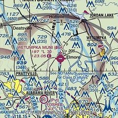
| Sectional chart |
|---|
|
| Airport distance calculator |
|---|
|
|
| Sunrise and sunset |
|---|
|
Times for 24-Jul-2025
| | Local
(UTC-5) | | Zulu
(UTC) |
|---|
| Morning civil twilight | | 05:28 | | 10:28 |
| Sunrise | | 05:55 | | 10:55 |
| Sunset | | 19:48 | | 00:48 |
| Evening civil twilight | | 20:16 | | 01:16 |
|
| Current date and time |
|---|
| Zulu (UTC) | 24-Jul-2025 19:24:54 |
|---|
| Local (UTC-5) | 24-Jul-2025 14:24:54 |
|---|
|
| METAR |
|---|
KMXF
10nm S | 241855Z AUTO 13008KT 10SM FEW031 FEW038 SCT055 BKN070 OVC085 30/24 A3006 RMK AO2 RAB37E48 SLP180 P0000 T03010244
|
K1A9
11nm SW | 241855Z AUTO 10004KT 10SM BKN075 31/23 A3008 RMK AO2 T03070233
|
KMGM
14nm S | 241853Z 08010KT 10SM FEW037 BKN065 BKN080 30/23 A3009 RMK AO2 RAE10 SLP184 P0000 T03000233 $
|
|
| TAF |
|---|
KMXF
10nm S | 241200Z 2412/2517 09009KT 9999 OVC011 QNH3007INS BECMG 2416/2417 VRB06KT 9999 SCT020 QNH3009INS BECMG 2422/2423 09009KT 9000 -SHRA BKN030 QNH3012INS TEMPO 2423/2502 8000 -TSRA BKN025CB BECMG 2502/2503 VRB06KT 9999 NSW SCT015 BKN030 QNH3002INS TX30/2419Z TN24/2510Z
|
KMGM
14nm S | 241721Z 2418/2518 11009KT P6SM VCSH SCT035 BKN050 PROB30 2420/2502 VRB10G20KT 4SM TSRA BKN035CB FM250200 10003KT P6SM SCT150 FM250800 11003KT P6SM BKN007 FM251600 16007KT P6SM BKN025 AMD LTD TO CLD VIS AND WIND
|
|
| NOTAMs |
|---|
NOTAMs are issued by the DoD/FAA and will open in a separate window not controlled by AirNav.
|
|


