FAA INFORMATION EFFECTIVE 11 JUNE 2026
Location
| FAA Identifier: | ALX |
| Lat/Long: | 32-54-53.1000N 085-57-46.6000W
32-54.885000N 085-57.776667W
32.9147500,-85.9629444
(estimated) |
| Elevation: | 685.8 ft. / 209.0 m (surveyed) |
| Variation: | 04W (2015) |
| From city: | 2 miles SW of ALEXANDER CITY, AL |
| Time zone: | UTC -5 (UTC -6 during Standard Time) |
| Zip code: | 35010 |
Airport Operations
| Airport use: | Open to the public |
| Activation date: | 04/1940 |
| Control tower: | no |
| ARTCC: | ATLANTA CENTER |
| FSS: | ANNISTON FLIGHT SERVICE STATION |
| NOTAMs facility: | ALX (NOTAM-D service available) |
| Attendance: | MON-FRI 0800-1700 |
| Wind indicator: | lighted |
| Segmented circle: | yes |
| Lights: | ACTVT REIL RWY 36; MIRL RWY 18/36 - CTAF. |
| Beacon: | white-green (lighted land airport)
Operates sunset to sunrise. |
Airport Communications
| CTAF/UNICOM: | 122.7 |
| WX AWOS-3PT: | 118.325 (256-329-1820) |
| MONTGOMERY APPROACH: | 121.2 |
| MONTGOMERY DEPARTURE: | 121.2 |
- APCH/DEP SVC PRVDD BY ATLANTA ARTCC ON FREQS 120.45/298.850 (COLUMBUS RCAG) WHEN MONTGOMERY APCH CTL CLSD.
Nearby radio navigation aids
| VOR radial/distance | | VOR name | | Freq | | Var |
|---|
| LGCr257/38.9 | | LAGRANGE VORTAC | | 115.60 | | 01E |
Airport Services
| Fuel available: | 100LL JET-A
100LL:24 HR CREDIT CARD SVC BOTH JET-A AND AVGAS. |
| Parking: | tiedowns |
| Airframe service: | NONE |
| Powerplant service: | NONE |
| Bottled oxygen: | NONE |
| Bulk oxygen: | NONE |
Runway Information
Runway 18/36
| Dimensions: | 5422 x 96 ft. / 1653 x 29 m |
| Surface: | asphalt/grooved, in fair condition |
| Weight bearing capacity: | |
| Runway edge lights: | medium intensity |
| RUNWAY 18 | | RUNWAY 36 |
| Latitude: | 32-55.331188N | | 32-54.438037N |
| Longitude: | 085-57.800010W | | 085-57.754248W |
| Elevation: | 685.8 ft. | | 611.9 ft. |
| Traffic pattern: | left | | left |
| Runway heading: | 182 magnetic, 178 true | | 002 magnetic, 358 true |
| Displaced threshold: | 623 ft. | | no |
| Markings: | nonprecision, in good condition | | nonprecision, in good condition |
| Visual slope indicator: | 4-light PAPI on left (3.00 degrees glide path)
PAPI UNUSBL BYD 5 DEG LEFT AND 6 DEG RIGHT OF CNTRLN. | | 4-light PAPI on left (3.00 degrees glide path)
PAPI UNUSBL BYD 6 DEG LEFT OF CNTRLN. |
| Runway end identifier lights: | | | yes |
| Touchdown point: | yes, no lights | | yes, no lights |
| Obstructions: | 129 ft. tree, 2006 ft. from runway, 572 ft. right of centerline, 15:1 slope to clear
APCH RATIO 15:1 FM DSPLCD THR. | | 46 ft. tree, 1117 ft. from runway, 347 ft. left of centerline, 19:1 slope to clear |
Airport Ownership and Management from official FAA records
| Ownership: | Publicly-owned |
| Owner: | CITY OF ALEXANDER CITY
PO BOX 552
ALEXANDER CITY, AL 35011
Phone (256) 329-9057 |
| Manager: | JACKSON HATTON
965 T.C. RUSSELL FIELD
ALEXANDER CITY, AL 35010
Phone 256-329-9057
ON CALL 256-392-2452. |
Additional Remarks
| - | TWY LGTS FOR TWY TURNOFF ONLY. |
| - | FOR CD CTC MONTGOMERY APCH AT 334-284-4575. WHEN APCH CLSD FOR CD CTC ATLANTA ARTCC AT 770-210-7692. |
Instrument Procedures
NOTE: All procedures below are presented as PDF files. If you need a reader for these files, you should download the free Adobe Reader.NOT FOR NAVIGATION. Please procure official charts for flight.
FAA instrument procedures published for use from 11 June 2026 at 0901Z to 09 July 2026 at 0900z.
IAPs - Instrument Approach Procedures |
|---|
| RNAV (GPS) RWY 18 | |
download (218KB) |
| RNAV (GPS) RWY 36 | |
download (236KB) |
| NOTE: Special Alternate Minimums apply | |
download (154KB) |
| NOTE: Special Take-Off Minimums/Departure Procedures apply | |
download (480KB) |
Other nearby airports with instrument procedures:
KSCD - Merkel Field Sylacauga Municipal Airport (23 nm NW)
08A - Wetumpka Municipal Airport (30 nm SW)
06A - Moton Field Municipal Airport (31 nm SE)
KAUO - Auburn University Regional Airport (32 nm SE)
02A - Chilton County Airport (33 nm W)
|
|

Road maps at:
MapQuest
Bing
Google
| Aerial photo |
|---|
WARNING: Photo may not be current or correct
 Photo courtesy of Jay Taffet / FBO Capital
Photo taken 24-Oct-2013
looking north.
Photo courtesy of Jay Taffet / FBO Capital
Photo taken 24-Oct-2013
looking north.
Do you have a better or more recent aerial photo of Thomas C Russell Field Airport that you would like to share? If so, please send us your photo.
|
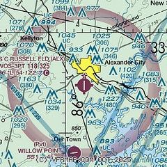
| Sectional chart |
|---|
|
| Airport distance calculator |
|---|
|
|
| Sunrise and sunset |
|---|
|
Times for 05-Jul-2026
| | Local
(UTC-5) | | Zulu
(UTC) |
|---|
| Morning civil twilight | | 05:13 | | 10:13 |
| Sunrise | | 05:42 | | 10:42 |
| Sunset | | 19:55 | | 00:55 |
| Evening civil twilight | | 20:23 | | 01:23 |
|
| Current date and time |
|---|
| Zulu (UTC) | 06-Jul-2026 03:08:21 |
|---|
| Local (UTC-5) | 05-Jul-2026 22:08:21 |
|---|
|
| METAR |
|---|
| KALX | 060255Z AUTO 09003KT 7SM CLR 24/23 A2997 RMK AO2 LTG DSNT E-S
|
|
| TAF |
|---|
KAUO
33nm SE | 060000Z 0600/0624 20002KT P6SM SCT050 TEMPO 0600/0603 4SM TSRA BKN040CB FM060300 VRB03KT P6SM BKN250 FM061000 VRB03KT P6SM OVC007 FM061600 22005KT P6SM BKN050 PROB30 0620/0624 4SM TSRA BKN040CB
|
|
| NOTAMs |
|---|
NOTAMs are issued by the DoD/FAA and will open in a separate window not controlled by AirNav.
|
|

