FAA INFORMATION EFFECTIVE 30 OCTOBER 2025
Location
| FAA Identifier: | AUO |
| Lat/Long: | 32-36-54.4000N 085-26-02.4000W
32-36.906667N 085-26.040000W
32.6151111,-85.4340000
(estimated) |
| Elevation: | 776.8 ft. / 236.8 m (surveyed) |
| Variation: | 04W (2015) |
| From city: | 2 miles E of AUBURN, AL |
| Time zone: | UTC -6 (UTC -5 during Daylight Saving Time) |
| Zip code: | 36801 |
Airport Operations
| Airport use: | Open to the public |
| Activation date: | 03/1941 |
| Control tower: | yes |
| ARTCC: | ATLANTA CENTER |
| FSS: | ANNISTON FLIGHT SERVICE STATION |
| NOTAMs facility: | AUO (NOTAM-D service available) |
| Attendance: | MON-FRI 0700-2100, ALL SAT-SUN 0800-1700 |
| Wind indicator: | lighted |
| Segmented circle: | yes |
| Lights: | WHEN ATCT CLSD, ACTVT MALSF RWY 36; PAPI RWY 29 & 36; MIRL RWY 11/29; HIRL RWY 18/36 - CTAF. |
| Beacon: | white-green (lighted land airport)
Operates sunset to sunrise. |
Airport Communications
| CTAF: | 123.875 |
| UNICOM: | 123.0 |
| WX AWOS-3PT: | 132.575 (334-501-0387) |
| AUBURN GROUND: | 121.625 [0700-2100 MON-FRI; 0800-1700 SAT & SUN] |
| AUBURN TOWER: | 123.875 [0700-2100 MON-FRI; 0800-1700 SAT & SUN] |
| ATLANTA APPROACH: | 125.5 126.55 ;7000 FT & ABV |
| ATLANTA DEPARTURE: | 125.5 126.55 ;7000 FT & ABV |
| CLEARANCE DELIVERY: | 121.625 118.7 ;WHEN AUO TWR CLSD |
- APCH/DEP SVC PRVDD BY ATLANTA LARGE TRACON 125.5 (0515-2200) OTHER TIMES ATLANTA ARTCC 120.45/298.850 (COLUMBUS RCAG).
Nearby radio navigation aids
| VOR radial/distance | | VOR name | | Freq | | Var |
|---|
| LSFr312/28.0 | | LAWSON VOR/DME | | 111.40 | | 05W |
| LGCr203/28.5 | | LAGRANGE VORTAC | | 115.60 | | 01E |
Airport Services
| Fuel available: | 100LL JET-A JET-A+
100LL:SVC AFT HRS & HOL 334-501-3100. |
| Parking: | tiedowns |
| Airframe service: | NONE |
| Powerplant service: | NONE |
| Bottled oxygen: | NONE |
| Bulk oxygen: | NONE |
Runway Information
Runway 18/36
| Dimensions: | 5264 x 100 ft. / 1604 x 30 m |
| Surface: | asphalt/grooved, in good condition |
| Weight bearing capacity: | | Single wheel: | 45.0 | | Double wheel: | 75.0 |
|
| Runway edge lights: | high intensity |
| RUNWAY 18 | | RUNWAY 36 |
| Latitude: | 32-37.212078N | | 32-36.344207N |
| Longitude: | 085-26.162142W | | 085-26.180738W |
| Elevation: | 776.8 ft. | | 731.1 ft. |
| Traffic pattern: | left | | left |
| Runway heading: | 185 magnetic, 181 true | | 005 magnetic, 001 true |
| Markings: | precision, in good condition | | precision, in good condition |
| Visual slope indicator: | | | 4-light PAPI on left (3.00 degrees glide path) |
| Approach lights: | | | MALSF: 1,400 foot medium intensity approach lighting system with sequenced flashers |
| Touchdown point: | yes, no lights | | yes, no lights |
| Instrument approach: | | | ILS/DME |
| Obstructions: | 41 ft. tree, 1213 ft. from runway, 415 ft. right of centerline, 24:1 slope to clear | | 9 ft. tree, 524 ft. from runway, 335 ft. right of centerline, 36:1 slope to clear |
Runway 11/29
| Dimensions: | 4000 x 75 ft. / 1219 x 23 m |
| Surface: | asphalt, in good condition |
| Weight bearing capacity: | | Single wheel: | 25.0 | | Double wheel: | 42.0 |
|
| Runway edge lights: | medium intensity |
| RUNWAY 11 | | RUNWAY 29 |
| Latitude: | 32-37.174865N | | 32-36.978580N |
| Longitude: | 085-26.241078W | | 085-25.497000W |
| Elevation: | 774.9 ft. | | 766.3 ft. |
| Traffic pattern: | left | | left |
| Runway heading: | 111 magnetic, 107 true | | 291 magnetic, 287 true |
| Displaced threshold: | no | | 297 ft. |
| Markings: | nonprecision, in good condition | | nonprecision, in good condition |
| Visual slope indicator: | | | 4-light PAPI on left (3.00 degrees glide path) |
| Touchdown point: | yes, no lights | | yes, no lights |
| Obstructions: | 22 ft. trees, 379 ft. from runway, 193 ft. left of centerline, 8:1 slope to clear | | 62 ft. tree, 1014 ft. from runway, 373 ft. right of centerline, 13:1 slope to clear
APCH RATIO 26:1 FROM DSPLCD THLD. |
Airport Ownership and Management from official FAA records
| Ownership: | Publicly-owned |
| Owner: | AUBURN UNIVERSITY
2150 BENT CREEK RD.
AUBURN, AL 36830
Phone 334-844-4597 |
| Manager: | WILLIAM T. HUTTO
2150 BENT CREEK RD.
AUBURN, AL 36830
Phone 334-844-4606 |
Additional Remarks
| - | JET START CPBLTY AVBL. |
| - | HVY FLT STUDENT ACTVTY WI 35NM OF ARPT. |
Instrument Procedures
NOTE: All procedures below are presented as PDF files. If you need a reader for these files, you should download the free Adobe Reader.NOT FOR NAVIGATION. Please procure official charts for flight.
FAA instrument procedures published for use from 30 October 2025 at 0901Z to 27 November 2025 at 0900Z.
IAPs - Instrument Approach Procedures |
|---|
| ILS OR LOC RWY 36 **CHANGED** | |
download (310KB) |
| RNAV (GPS) RWY 11 **CHANGED** | |
download (248KB) |
| RNAV (GPS) RWY 18 **CHANGED** | |
download (273KB) |
| RNAV (GPS) RWY 29 **CHANGED** | |
download (232KB) |
| RNAV (GPS) RWY 36 **CHANGED** | |
download (270KB) |
| NOTE: Special Alternate Minimums apply | |
download (160KB) |
| NOTE: Special Take-Off Minimums/Departure Procedures apply | |
download (302KB) |
Other nearby airports with instrument procedures:
06A - Moton Field Municipal Airport (16 nm SW)
7A3 - Lanett Regional Airport (16 nm NE)
KCSG - Columbus Airport (26 nm E)
KLSF - Lawson Army Airfield (Fort Benning) (28 nm SE)
KLGC - LaGrange-Callaway Airport (30 nm NE)
|
|

Road maps at:
MapQuest
Bing
Google
| Aerial photo |
|---|
WARNING: Photo may not be current or correct
 Photo by William T. Hutto, Jr., A.A.E., Ph.D.
Photo taken 08-Aug-2012
looking north.
Photo by William T. Hutto, Jr., A.A.E., Ph.D.
Photo taken 08-Aug-2012
looking north.
Do you have a better or more recent aerial photo of Auburn University Regional Airport that you would like to share? If so, please send us your photo.
|
| Sectional chart |
|---|
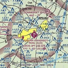
|
| Airport distance calculator |
|---|
|
|
| Sunrise and sunset |
|---|
|
Times for 07-Nov-2025
| | Local
(UTC-6) | | Zulu
(UTC) |
|---|
| Morning civil twilight | | 05:40 | | 11:40 |
| Sunrise | | 06:05 | | 12:05 |
| Sunset | | 16:45 | | 22:45 |
| Evening civil twilight | | 17:11 | | 23:11 |
|
| Current date and time |
|---|
| Zulu (UTC) | 07-Nov-2025 09:16:47 |
|---|
| Local (UTC-6) | 07-Nov-2025 03:16:47 |
|---|
|
| METAR |
|---|
| KAUO | 070856Z AUTO 16003KT 10SM CLR 13/09 A3002 RMK AO2 SLP155 T01330094 58005 $
|
|
| TAF |
|---|
| KAUO | 070539Z 0706/0806 VRB03KT P6SM SKC FM071700 20007KT P6SM BKN040 PROB30 0721/0803 4SM -SHRA FM080300 VRB04KT P6SM BKN015
|
|
| NOTAMs |
|---|
NOTAMs are issued by the DoD/FAA and will open in a separate window not controlled by AirNav.
|
|


