FAA INFORMATION EFFECTIVE 25 DECEMBER 2025
Location
| FAA Identifier: | 0R7 |
| Lat/Long: | 31-59-25.0000N 093-18-27.4000W
31-59.416667N 093-18.456667W
31.9902778,-93.3076111
(estimated) |
| Elevation: | 177.2 ft. / 54.0 m (surveyed) |
| Variation: | 01E (2020) |
| From city: | 2 miles SE of COUSHATTA, LA |
| Time zone: | UTC -6 (UTC -5 during Daylight Saving Time) |
| Zip code: | 71019 |
Airport Operations
| Airport use: | Open to the public |
| Control tower: | no |
| ARTCC: | HOUSTON CENTER |
| FSS: | DE RIDDER FLIGHT SERVICE STATION |
| NOTAMs facility: | DRI (NOTAM-D service available) |
| Attendance: | UNATNDD |
| Wind indicator: | lighted |
| Segmented circle: | no |
| Lights: | MIRL RY 18/36, REIL RYS 18 & 36 PRESET LOW INTST DUSK-DAWN; TO INCR INTST ACTVT - CTAF. |
| Beacon: | white-green (lighted land airport)
AIRPORT BEACON OUT OF SERVICE. Operates sunset to sunrise. |
Airport Communications
| CTAF: | 122.9 |
| POLK APPROACH: | 132.05 |
| POLK DEPARTURE: | 132.05 |
| WX AWOS-3 at IER (19 nm SE): | 119.025 (318-352-1575) |
Nearby radio navigation aids
| VOR radial/distance | | VOR name | | Freq | | Var |
|---|
| EMGr142/28.6 | | ELM GROVE VORTAC | | 116.65 | | 07E |
| NDB name | | Hdg/Dist | | Freq | | Var | | ID |
|---|
| NATCHITOCHES | | 326/23.2 | | 407 | | 04E | | OOC | --- --- -.-. |
Airport Services
| Parking: | tiedowns |
| Airframe service: | NONE |
| Powerplant service: | NONE |
| Bottled oxygen: | NONE |
| Bulk oxygen: | NONE |
Runway Information
Runway 18/36
| Dimensions: | 5002 x 74 ft. / 1525 x 23 m |
| Surface: | asphalt, in good condition |
| Weight bearing capacity: | |
| Runway edge lights: | medium intensity |
| RUNWAY 18 | | RUNWAY 36 |
| Latitude: | 31-59.828942N | | 31-59.004012N |
| Longitude: | 093-18.455817W | | 093-18.457495W |
| Elevation: | 177.0 ft. | | 165.3 ft. |
| Traffic pattern: | left | | left |
| Runway heading: | 179 magnetic, 180 true | | 359 magnetic, 000 true |
| Markings: | nonprecision, in fair condition | | nonprecision, in fair condition |
| Visual slope indicator: | 2-light PAPI on left (3.00 degrees glide path)
RWY 18 PAPI OUT OF SERVICE | | 2-light PAPI on left (3.00 degrees glide path)
RWY 36 PAPI OUT OF SERVICE |
| Runway end identifier lights: | yes
RWY 18 REILS OUT OF SERVICE | | yes
RWY 36 REILS OUT OF SERVICE |
| Touchdown point: | yes, no lights | | yes, no lights |
| Obstructions: | 53 ft. trees, 1262 ft. from runway, 243 ft. left of centerline, 20:1 slope to clear | | 104 ft. trees, 2195 ft. from runway, 229 ft. left of centerline, 19:1 slope to clear |
Airport Ownership and Management from official FAA records
| Ownership: | Publicly-owned |
| Owner: | RED RIVER PARISH POLICE JURY
PO DRAWER 709
COUSHATTA, LA 71019
Phone 318-932-5719 |
| Manager: | JESSIE DAVIS
PO DRAWER 709
COUSHATTA, LA 71019
Phone 318-932-5710 |
Additional Remarks
| - | 66 FT TREES 253 FT EAST OF RWY CNTRLN FULL LENGTH. |
| - | FOR CD CTC FORT WORTH ARTCC AT 817-858-7584. |
Instrument Procedures
NOTE: All procedures below are presented as PDF files. If you need a reader for these files, you should download the free Adobe Reader.NOT FOR NAVIGATION. Please procure official charts for flight.
FAA instrument procedures published for use from 25 December 2025 at 0901z to 22 January 2026 at 0900z.
IAPs - Instrument Approach Procedures |
|---|
| RNAV (GPS) RWY 18 | |
download (202KB) |
| NOTE: Special Take-Off Minimums/Departure Procedures apply | |
download (216KB) |
Other nearby airports with instrument procedures:
KIER - Natchitoches Regional Airport (19 nm SE)
3F3 - C E 'Rusty' Williams Airport (24 nm W)
3R4 - Hart Airport (28 nm S)
F88 - Jonesboro Airport (32 nm NE)
0R5 - David G Joyce Airport (33 nm E)
|
|

Road maps at:
MapQuest
Bing
Google
| Aerial photo |
|---|
WARNING: Photo may not be current or correct
 Photo by Carl Hennigan
Taken in May 2007
Photo by Carl Hennigan
Taken in May 2007
Do you have a better or more recent aerial photo of The Red River Airport that you would like to share? If so, please send us your photo.
|
| Sectional chart |
|---|
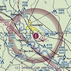
|
| Airport distance calculator |
|---|
|
|
| Sunrise and sunset |
|---|
|
Times for 01-Jan-2026
| | Local
(UTC-6) | | Zulu
(UTC) |
|---|
| Morning civil twilight | | 06:48 | | 12:48 |
| Sunrise | | 07:15 | | 13:15 |
| Sunset | | 17:19 | | 23:19 |
| Evening civil twilight | | 17:46 | | 23:46 |
|
| Current date and time |
|---|
| Zulu (UTC) | 02-Jan-2026 04:58:14 |
|---|
| Local (UTC-6) | 01-Jan-2026 22:58:14 |
|---|
|
| METAR |
|---|
KIER
19nm SE | 020435Z AUTO 00000KT 10SM CLR 14/08 A2995 RMK AO2 T01360081
|
KAQV
21nm S | 020447Z AUTO VRB04KT 10SM CLR 14/11 A2995 RMK AO2 SLP141 T01440111
|
K3F3
24nm W | 020435Z AUTO 16012KT 10SM CLR 16/07 A2996 RMK AO2 T01560074
|
KBAD
36nm NW | 020355Z AUTO 13006KT 10SM BKN190 14/05 A2991 RMK AO2 SLP132 T01380046
|
|
| TAF |
|---|
KSHV
38nm NW | 011754Z 0118/0218 22009KT P6SM BKN250 FM020000 19006KT P6SM SCT150 OVC250 FM020800 19006KT P6SM BKN150 OVC250 FM021100 19009KT P6SM BKN025 OVC150 FM021600 22014G20KT P6SM BKN250
|
|
| NOTAMs |
|---|
NOTAMs are issued by the DoD/FAA and will open in a separate window not controlled by AirNav.
|
|

