FAA INFORMATION EFFECTIVE 09 JULY 2026
Location
| FAA Identifier: | 15F |
| Lat/Long: | 33-11-29.3527N 099-43-04.3415W
33-11.489212N 099-43.072358W
33.1914869,-99.7178726
(estimated) |
| Elevation: | 1625.4 ft. / 495.4 m (surveyed) |
| Variation: | 05E (2020) |
| From city: | 2 miles N of HASKELL, TX |
| Time zone: | UTC -5 (UTC -6 during Standard Time) |
| Zip code: | 79521 |
Airport Operations
| Airport use: | Open to the public |
| Activation date: | 03/1971 |
| Control tower: | no |
| ARTCC: | FORT WORTH CENTER |
| FSS: | FORT WORTH FLIGHT SERVICE STATION |
| NOTAMs facility: | FTW (NOTAM-D service available) |
| Attendance: | UNATNDD |
| Wind indicator: | lighted |
| Segmented circle: | yes |
| Lights: | ACTVT MIRL RWY 18/36 - 122.8. NMRS LTS OUT, OBSCURED BY VEGETATION. |
| Beacon: | white-green (lighted land airport)
Operates sunset to sunrise. |
Airport Communications
- APCH/DEP SVC PRVDD BY FORT WORTH ARTCC (ZFW) ON FREQS 133.5/350.35 (WICHITA FALLS RCAG).
Airport Services
| Fuel available: | 100LL
100LL:FOR FUEL WKDAYS 0800-1700 CALL 940-207-1855; NIGHTS & WKENDS CALL 940-864-2345. |
| Parking: | hangars and tiedowns |
| Bottled oxygen: | NONE |
| Bulk oxygen: | NONE |
Runway Information
Runway 18/36
| Dimensions: | 3420 x 50 ft. / 1042 x 15 m |
| Surface: | asphalt/L
NMRS CRACKS, SPALLING, LOOSE STONES, VEGETATION GROWING. |
| Weight bearing capacity: | |
| Runway edge lights: | medium intensity |
| Runway edge markings: | MKG POOR. |
| RUNWAY 18 | | RUNWAY 36 |
| Latitude: | 33-11.768548N | | 33-11.209875N |
| Longitude: | 099-43.026797W | | 099-43.117915W |
| Elevation: | 1589.3 ft. | | 1625.4 ft. |
| Traffic pattern: | left | | left |
| Runway heading: | 183 magnetic, 188 true | | 003 magnetic, 008 true |
| Displaced threshold: | 206 ft. | | no |
| Markings: | nonprecision, in poor condition | | nonprecision, in poor condition |
| Touchdown point: | yes, no lights | | yes, no lights |
| Obstructions: | 35 ft. pline, 600 ft. from runway, 325 ft. right of centerline, 11:1 slope to clear
APCH SLOPE 17:1 TO DSPLCD THLD. | | 15 ft. road, 416 ft. from runway, 14:1 slope to clear
4 FT PIPE 174 FT DSTC, 49 FT. L |
Airport Ownership and Management from official FAA records
| Ownership: | Publicly-owned |
| Owner: | CITY OF HASKELL
CITY HALL PO BOX 1003
HASKELL, TX 79521
Phone 940-864-2333 |
| Manager: | MATT USSERY
301 SOUTH 1ST STRET
HASKELL, TX 79521
Phone 940-864-2333
PUBLIC WORKS DIRECTOR. |
Additional Remarks
| - | NO LINE OF SIGHT BETWEEN RY ENDS. |
| - | FOR CD CTC FORT WORTH ARTCC AT 817-858-7584. |
Instrument Procedures
NOTE: All procedures below are presented as PDF files. If you need a reader for these files, you should download the free Adobe Reader.NOT FOR NAVIGATION. Please procure official charts for flight.
FAA instrument procedures published for use from 09 July 2026 at 0901Z to 06 August 2026 at 0900Z.
IAPs - Instrument Approach Procedures |
|---|
| RNAV (GPS)-A **CHANGED** | |
download (147KB) |
| NOTE: Special Take-Off Minimums/Departure Procedures apply **CHANGED** | |
download (329KB) |
Other nearby airports with instrument procedures:
F56 - Arledge Field Airport (17 nm S)
60F - Seymour Municipal Airport (36 nm NE)
T23 - Albany Municipal Airport (36 nm SE)
KONY - Olney Municipal Airport (46 nm E)
KABI - Abilene Regional Airport (47 nm S)
|
|

Road maps at:
MapQuest
Bing
Google
| Aerial photo |
|---|
WARNING: Photo may not be current or correct
 Photo taken 22-Jun-2008
Do you have a better or more recent aerial photo of Haskell Municipal Airport that you would like to share? If so, please send us your photo.
|
| Sectional chart |
|---|
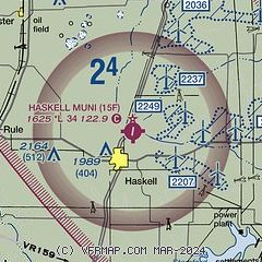
|
| Airport distance calculator |
|---|
|
|
| Sunrise and sunset |
|---|
|
Times for 18-Jul-2026
| | Local
(UTC-5) | | Zulu
(UTC) |
|---|
| Morning civil twilight | | 06:16 | | 11:16 |
| Sunrise | | 06:43 | | 11:43 |
| Sunset | | 20:47 | | 01:47 |
| Evening civil twilight | | 21:15 | | 02:15 |
|
| Current date and time |
|---|
| Zulu (UTC) | 18-Jul-2026 14:21:18 |
|---|
| Local (UTC-5) | 18-Jul-2026 09:21:18 |
|---|
|
| METAR |
|---|
KABI
47nm S | 181352Z 18012KT 8SM CLR 26/23 A3010 RMK AO2 SLP166 T02560228 $
|
KDYS
47nm S | 181255Z AUTO 17013KT 10SM CLR 24/21 A3006 RMK AO2 SLP155 T02380213
|
|
| TAF |
|---|
KABI
47nm S | 181122Z 1812/1912 15008KT P6SM FEW250 FM181500 18014G22KT P6SM FEW250 FM190100 17008KT P6SM SCT250
|
KDYS
47nm S | 180503Z 1805/1906 18012G18KT 9999 BKN030 QNH3004INS BECMG 1813/1814 19015G25KT 9999 BKN040 QNH3004INS BECMG 1818/1819 19012G18KT 9999 BKN050 QNH3005INS TX31/1822Z TN23/1812Z LAST NO AMDS AFT 1805 NEXT 1813
|
|
| NOTAMs |
|---|
NOTAMs are issued by the DoD/FAA and will open in a separate window not controlled by AirNav.
|
|

