FAA INFORMATION EFFECTIVE 09 JULY 2026
Location
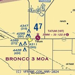
| FAA Identifier: | 18T |
| Lat/Long: | 33-15-38.9000N 103-16-42.5500W
33-15.648333N 103-16.709167W
33.2608056,-103.2784861
(estimated) |
| Elevation: | 3986 ft. / 1214.9 m (surveyed) |
| Variation: | 10E (1985) |
| From city: | 3 miles E of TATUM, NM |
| Time zone: | UTC -6 (UTC -7 during Standard Time) |
| Zip code: | 88267 |
Airport Operations
| Airport use: | Open to the public |
| Activation date: | 06/1958 |
| Control tower: | no |
| ARTCC: | FORT WORTH CENTER |
| FSS: | ALBUQUERQUE FLIGHT SERVICE STATION |
| NOTAMs facility: | ABQ (NOTAM-D service available) |
| Attendance: | UNATNDD |
| Wind indicator: | yes |
| Segmented circle: | yes |
| Beacon: | white-green (lighted land airport)
OTS INDEFLY. Operates sunset to sunrise. |
Airport Communications
Nearby radio navigation aids
| VOR radial/distance | | VOR name | | Freq | | Var |
|---|
| HOBr348/37.4 | | HOBBS VORTAC | | 111.00 | | 11E |
Airport Services
Runway Information
Runway 12/30
| Dimensions: | 2920 x 60 ft. / 890 x 18 m |
| Surface: | asphalt, in poor condition
NUMEROUS UNFILLED CRACKS WITH 1 FT VEGETATION. |
| Weight bearing capacity: | | PCN 3 /F/C/Y/T | | Single wheel: | 10.0 |
|
| Runway edge markings: | RWY 30 MARKING FADED OR MISSING.RED "X" ON RWY NMBR. |
| RUNWAY 12 | | RUNWAY 30 |
| Latitude: | 33-15.808333N | | 33-15.488333N |
| Longitude: | 103-16.923333W | | 103-16.495000W |
| Elevation: | 3986.0 ft. | | 3986.0 ft. |
| Traffic pattern: | left | | left |
| Runway heading: | 122 magnetic, 132 true | | 302 magnetic, 312 true |
| Markings: | basic, in poor condition | | basic, in poor condition |
| Approach lights: | NSTD
ODALS OTS INDEFLY; 3 LGTS ON EXTDD CNTRLN; NONSTD SPACING. | | NSTD
ODALS OTS INDEFLY; 3 LGTS ON EXTDD CNTRLN; NONSTD SPACING. |
| Obstructions: | 5 ft. fence, 265 ft. from runway, 135 ft. both sides of centerline, 13:1 slope to clear | | 15 ft. road, 400 ft. from runway, 155 ft. left of centerline, 13:1 slope to clear |
Airport Ownership and Management from official FAA records
| Ownership: | Publicly-owned |
| Owner: | TOWN OF TATUM
120 W BROADWAY, P.O BOX 156
TATUM, NM 88267
Phone 575-398-4633 |
| Manager: | ARNOLD RAMIREZ
120 W BROADWAY, P.O BOX 156
TATUM, NM 88267
Phone 575-398-4633 |
Additional Remarks
| - | GATE CODE - FLD ELEV. |
| - | WILDLIFE ON & INVOF OF ARPT. |
| - | FOR CD CTC FORT WORTH ARTCC AT 817-858-7584. |
| - | 6"-12" VEGETATION IN ALL ON ARPT PAVEMENTS; RAMP TIE DOWNS COVERED BY VEGETATION, 2 FT-10 FT SCTRD BRUSH NORTH SIDE TRANSITION AREA. |
Instrument Procedures
There are no published instrument procedures at 18T.
Some nearby airports with instrument procedures:
E06 - Lea County/Zip Franklin Memorial Airport (20 nm S)
F98 - Yoakum County Airport (23 nm E)
KHOB - Lea County Regional Airport (35 nm S)
KGNC - Gaines County Airport (47 nm SE)
KLLN - Levelland Municipal Airport (49 nm E)
|
|

Road maps at:
MapQuest
Bing
Google
| Aerial photo |
|---|
WARNING: Photo may not be current or correct

Do you have a better or more recent aerial photo of Tatum Airport that you would like to share? If so, please send us your photo.
|
| Sectional chart |
|---|
|
| Airport distance calculator |
|---|
|
|
| Sunrise and sunset |
|---|
|
Times for 30-Jul-2026
| | Local
(UTC-6) | | Zulu
(UTC) |
|---|
| Morning civil twilight | | 05:38 | | 11:38 |
| Sunrise | | 06:06 | | 12:06 |
| Sunset | | 19:53 | | 01:53 |
| Evening civil twilight | | 20:21 | | 02:21 |
|
| Current date and time |
|---|
| Zulu (UTC) | 30-Jul-2026 18:25:52 |
|---|
| Local (UTC-6) | 30-Jul-2026 12:25:52 |
|---|
|
| METAR |
|---|
KHOB
36nm S | 301750Z 14007G16KT 10SM CLR 33/13 A3008
|
KGNC
47nm SE | 301755Z AUTO 16009KT 10SM CLR 34/16 A3010 RMK AO2 T03360155 10342 20222
|
KLLN
49nm E | 301755Z AUTO 15013KT 9SM CLR 33/15 A3008 RMK AO2
|
|
| TAF |
|---|
KHOB
36nm S | 301720Z 3018/3118 15011KT P6SM SCT250
|
|
| NOTAMs |
|---|
NOTAMs are issued by the DoD/FAA and will open in a separate window not controlled by AirNav.
|
|


