FAA INFORMATION EFFECTIVE 02 OCTOBER 2025
Location
| FAA Identifier: | F98 |
| Lat/Long: | 33-13-01.9000N 102-49-48.3000W
33-13.031667N 102-49.805000W
33.2171944,-102.8300833
(estimated) |
| Elevation: | 3705 ft. / 1129.3 m (surveyed) |
| Variation: | 07E (2010) |
| From city: | 1 mile NW of PLAINS, TX |
| Time zone: | UTC -5 (UTC -6 during Standard Time) |
| Zip code: | 79355 |
Airport Operations
| Airport use: | Open to the public |
| Activation date: | 04/1948 |
| Control tower: | no |
| ARTCC: | FORT WORTH CENTER |
| FSS: | FORT WORTH FLIGHT SERVICE STATION |
| NOTAMs facility: | FTW (NOTAM-D service available) |
| Attendance: | IREG |
| Wind indicator: | lighted |
| Segmented circle: | yes |
| Lights: | DUSK-DAWN. MIRL RWYS 03/21 & 17/35 PRESET LOW INTST; TO INCR INTST ACTVT - CTAF. |
| Beacon: | white-green (lighted land airport)
Operates sunset to sunrise. |
Airport Communications
| CTAF: | 122.9 |
| WX AWOS-3PT at E57 (15 nm S): | 118.275 (806-592-3681) |
- APCH/DEP CTL SVC PRVDD BY FORT WORTH ARTCC (ZFW) ON FREQS 132.6/269.05 (LUBBOCK RCAG).
Airport Services
| Fuel available: | 100LL
100LL:SELF SERVE. |
| Parking: | hangars and tiedowns |
| Airframe service: | NONE |
| Powerplant service: | NONE |
| Bottled oxygen: | NONE |
| Bulk oxygen: | NONE |
Runway Information
Runway 3/21
| Dimensions: | 5001 x 75 ft. / 1524 x 23 m |
| Surface: | asphalt, in good condition |
| Runway edge lights: | medium intensity |
| RUNWAY 3 | | RUNWAY 21 |
| Latitude: | 33-12.736570N | | 33-13.365595N |
| Longitude: | 102-49.932457W | | 102-49.298222W |
| Elevation: | 3676.9 ft. | | 3704.6 ft. |
| Traffic pattern: | left | | left |
| Runway heading: | 033 magnetic, 040 true | | 213 magnetic, 220 true |
| Markings: | nonprecision, in good condition | | nonprecision, in good condition |
| Touchdown point: | yes, no lights | | yes, no lights |
| Obstructions: | none | | 35 ft. pole, 1521 ft. from runway, 37:1 slope to clear
4 FT BERM 115 FT LEFT OF RWY CNTRLN AT THR, 3-4 FT SCATTERED BRUSH 0-200 FT FM THR ACRS APCH. |
Runway 17/35
| Dimensions: | 3924 x 60 ft. / 1196 x 18 m |
| Surface: | asphalt, in good condition |
| Weight bearing capacity: | |
| Runway edge lights: | medium intensity |
| RUNWAY 17 | | RUNWAY 35 |
| Latitude: | 33-13.329507N | | 33-12.682635N |
| Longitude: | 102-50.042582W | | 102-50.048705W |
| Elevation: | 3688.6 ft. | | 3680.1 ft. |
| Traffic pattern: | left | | left |
| Runway heading: | 173 magnetic, 180 true | | 353 magnetic, 360 true |
| Markings: | basic, in good condition | | basic, in good condition |
| Touchdown point: | yes, no lights | | yes, no lights |
| Obstructions: | 30 ft. pole, 548 ft. from runway, 98 ft. right of centerline, 11:1 slope to clear | | 25 ft. pole, 880 ft. from runway, 70 ft. right of centerline, 27:1 slope to clear |
Airport Ownership and Management from official FAA records
| Ownership: | Publicly-owned |
| Owner: | YOAKUM COUNTY
PO BOX 456
PLAINS, TX 79355
Phone 806-456-7491 |
| Manager: | TOMMY BOX
PO BOX 456
PLAINS, TX 79355
Phone 806-592-1267
TBOX@YOAKUMCOUNTY.ORG |
Additional Remarks
| - | FOR CD CTC FORT WORTH ARTCC AT 817-858-7584. |
Instrument Procedures
NOTE: All procedures below are presented as PDF files. If you need a reader for these files, you should download the free Adobe Reader.NOT FOR NAVIGATION. Please procure official charts for flight.
FAA instrument procedures published for use from 02 October 2025 at 0901Z to 30 October 2025 at 0900z.
IAPs - Instrument Approach Procedures |
|---|
| RNAV (GPS) RWY 03 | |
download (216KB) |
| RNAV (GPS) RWY 21 | |
download (220KB) |
| NOTE: Special Take-Off Minimums/Departure Procedures apply | |
download (113KB) |
Other nearby airports with instrument procedures:
KLLN - Levelland Municipal Airport (31 nm NE)
KBFE - Terry County Airport (32 nm E)
E06 - Lea County/Zip Franklin Memorial Airport (33 nm SW)
KGNC - Gaines County Airport (34 nm S)
KHOB - Lea County Regional Airport (37 nm SW)
|
|

Road maps at:
MapQuest
Bing
Google
| Aerial photo |
|---|
WARNING: Photo may not be current or correct

Do you have a better or more recent aerial photo of Yoakum County Airport that you would like to share? If so, please send us your photo.
|
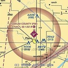
| Sectional chart |
|---|
|
| Airport distance calculator |
|---|
|
|
| Sunrise and sunset |
|---|
|
Times for 18-Oct-2025
| | Local
(UTC-5) | | Zulu
(UTC) |
|---|
| Morning civil twilight | | 07:34 | | 12:34 |
| Sunrise | | 07:59 | | 12:59 |
| Sunset | | 19:14 | | 00:14 |
| Evening civil twilight | | 19:39 | | 00:39 |
|
| Current date and time |
|---|
| Zulu (UTC) | 19-Oct-2025 01:36:59 |
|---|
| Local (UTC-5) | 18-Oct-2025 20:36:59 |
|---|
|
| METAR |
|---|
KLLN
31nm NE | 190115Z AUTO 01006KT 10SM CLR 21/M06 A3006 RMK AO2
|
KGNC
34nm S | 190115Z AUTO 00000KT 10SM CLR 21/00 A3008 RMK AO2 T02101005
|
KHOB
38nm SW | 190115Z AUTO 32004KT 2SM HZ CLR 18/M02 A3005 RMK AO2
|
|
| TAF |
|---|
KHOB
38nm SW | 182001Z 1820/1918 30015G21KT P6SM SKC FM190200 03008KT P6SM SKC FM191300 15010KT P6SM SKC
|
|
| NOTAMs |
|---|
NOTAMs are issued by the DoD/FAA and will open in a separate window not controlled by AirNav.
|
|


