FAA INFORMATION EFFECTIVE 14 MAY 2026
Location
| FAA Identifier: | BFE |
| Lat/Long: | 33-10-23.3000N 102-11-34.5000W
33-10.388333N 102-11.575000W
33.1731389,-102.1929167
(estimated) |
| Elevation: | 3264.6 ft. / 995.1 m (surveyed) |
| Variation: | 09E (1995) |
| From city: | 4 miles E of BROWNFIELD, TX |
| Time zone: | UTC -5 (UTC -6 during Standard Time) |
| Zip code: | 79316 |
Airport Operations
| Airport use: | Open to the public |
| Activation date: | 12/1940 |
| Control tower: | no |
| ARTCC: | FORT WORTH CENTER |
| FSS: | FORT WORTH FLIGHT SERVICE STATION |
| NOTAMs facility: | FTW (NOTAM-D service available) |
| Attendance: | UNATNDD |
| Wind indicator: | lighted |
| Segmented circle: | yes |
| Lights: | MIRL RWY 02/20 PRESET LOW INTST; TO INCR INTST ACTVT - CTAF. |
| Beacon: | white-green (lighted land airport)
Operates sunset to sunrise. |
Airport Communications
| CTAF/UNICOM: | 122.8 |
| LUBBOCK APPROACH: | 119.2 119.9 |
| LUBBOCK DEPARTURE: | 119.2 119.9 |
Nearby radio navigation aids
| VOR radial/distance | | VOR name | | Freq | | Var |
|---|
| LBBr193/34.8 | | LUBBOCK VORTAC | | 109.20 | | 11E |
Airport Services
| Fuel available: | 100LL JET-A
100LL:FUEL SELF SVC 24 HRS. |
| Parking: | tiedowns |
Runway Information
Runway 2/20
| Dimensions: | 5218 x 75 ft. / 1590 x 23 m |
| Surface: | asphalt, in good condition |
| Weight bearing capacity: | | Single wheel: | 50.0 | | Double wheel: | 65.0 |
|
| Runway edge lights: | medium intensity |
| RUNWAY 2 | | RUNWAY 20 |
| Latitude: | 33-09.946825N | | 33-10.720223N |
| Longitude: | 102-11.817518W | | 102-11.369407W |
| Elevation: | 3253.2 ft. | | 3264.5 ft. |
| Traffic pattern: | left | | left |
| Runway heading: | 017 magnetic, 026 true | | 197 magnetic, 206 true |
| Markings: | nonprecision, in good condition | | nonprecision, in good condition |
| Visual slope indicator: | 2-light PAPI on left (3.00 degrees glide path) | | 2-light PAPI on left (3.00 degrees glide path) |
| Touchdown point: | yes, no lights | | yes, no lights |
| Obstructions: | none | | 40 ft. trees, 950 ft. from runway, 110 ft. left of centerline, 18:1 slope to clear |
Runway 13/31
| Dimensions: | 2765 x 75 ft. / 843 x 23 m |
| Surface: | asphalt, in good condition |
| Weight bearing capacity: | |
| RUNWAY 13 | | RUNWAY 31 |
| Latitude: | 33-10.653512N | | 33-10.331888N |
| Longitude: | 102-11.732953W | | 102-11.348923W |
| Elevation: | 3261.5 ft. | | 3250.3 ft. |
| Traffic pattern: | left | | left |
| Runway heading: | 126 magnetic, 135 true | | 306 magnetic, 315 true |
| Markings: | basic, in good condition | | basic, in good condition |
| Touchdown point: | yes, no lights | | yes, no lights |
| Obstructions: | 48 ft. pline, 1530 ft. from runway, 275 ft. left of centerline, 27:1 slope to clear | | 10 ft. road, 410 ft. from runway, 147 ft. right of centerline, 21:1 slope to clear |
Airport Ownership and Management from official FAA records
| Ownership: | Publicly-owned |
| Owner: | TERRY COUNTY
TERRY CO COURTHOUSE, 500 W. MAIN
BROWNFIELD, TX 79316
Phone 806-637-3797 |
| Manager: | BRAD TANKERSLEY
P.O. BOX 205
BROWNFIELD, TX 79316
Phone 806-543-9840 |
Additional Remarks
| - | FOR CD CTC FORT WORTH ARTCC AT 817-858-7584. |
| - | BIRDS & WILDLIFE ON AND INVOF ARPT. |
| - | RWY 02/20 PARL TWY POOR, EXTSV CRACKS. |
Instrument Procedures
NOTE: All procedures below are presented as PDF files. If you need a reader for these files, you should download the free Adobe Reader.NOT FOR NAVIGATION. Please procure official charts for flight.
FAA instrument procedures published for use from 14 May 2026 at 0901Z to 11 June 2026 at 0900Z.
IAPs - Instrument Approach Procedures |
|---|
| RNAV (GPS) RWY 02 | |
download (219KB) |
| RNAV (GPS) RWY 20 | |
download (219KB) |
| NOTE: Special Take-Off Minimums/Departure Procedures apply | |
download (305KB) |
Other nearby airports with instrument procedures:
KLLN - Levelland Municipal Airport (24 nm N)
F82 - Lubbock Executive Airpark (27 nm NE)
KLUV - Lamesa Municipal Airport (29 nm SE)
F98 - Yoakum County Airport (32 nm W)
F49 - City of Slaton/Larry T Neal Memorial Airport (33 nm NE)
|
|

Road maps at:
MapQuest
Bing
Google
| Aerial photo |
|---|
WARNING: Photo may not be current or correct

Do you have a better or more recent aerial photo of Terry County Airport that you would like to share? If so, please send us your photo.
|
| Sectional chart |
|---|
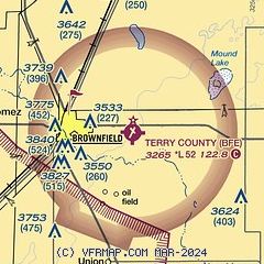
|
| Airport distance calculator |
|---|
|
|
| Sunrise and sunset |
|---|
|
Times for 29-May-2026
| | Local
(UTC-5) | | Zulu
(UTC) |
|---|
| Morning civil twilight | | 06:14 | | 11:14 |
| Sunrise | | 06:43 | | 11:43 |
| Sunset | | 20:50 | | 01:50 |
| Evening civil twilight | | 21:18 | | 02:18 |
|
| Current date and time |
|---|
| Zulu (UTC) | 30-May-2026 00:43:55 |
|---|
| Local (UTC-5) | 29-May-2026 19:43:55 |
|---|
|
| METAR |
|---|
KLLN
24nm N | 300015Z AUTO 21016KT 10SM CLR 29/12 A2986 RMK AO2
|
KLUV
29nm SE | 300015Z AUTO 19010KT 10SM CLR 30/15 A2986 RMK AO2
|
KLBB
35nm NE | 292353Z 18014KT 10SM FEW070 BKN200 30/13 A2984 RMK AO2 SLP053 CB DSNT N AND NE T03000133 10306 20261 56020
|
KGNC
38nm SW | 300015Z AUTO 18007KT 10SM CLR 30/12 A2990 RMK AO2 T03000115
|
|
| TAF |
|---|
KLBB
35nm NE | 292023Z 2920/3018 18011KT P6SM FEW040 BKN150 FM300300 16016KT P6SM BKN150 FM301300 22015KT P6SM SCT110
|
|
| NOTAMs |
|---|
NOTAMs are issued by the DoD/FAA and will open in a separate window not controlled by AirNav.
|
|


