FAA INFORMATION EFFECTIVE 14 MAY 2026
Location
| FAA Identifier: | LBB |
| Lat/Long: | 33-39-49.2000N 101-49-14.0000W
33-39.820000N 101-49.233333W
33.6636667,-101.8205556
(estimated) |
| Elevation: | 3282.4 ft. / 1000.5 m (surveyed) |
| Variation: | 06E (2020) |
| From city: | 4 miles N of LUBBOCK, TX |
| Time zone: | UTC -5 (UTC -6 during Standard Time) |
| Zip code: | 79403 |
Airport Operations
| Airport use: | Open to the public |
| Activation date: | 11/1937 |
| Control tower: | yes |
| ARTCC: | FORT WORTH CENTER |
| FSS: | FORT WORTH FLIGHT SERVICE STATION |
| NOTAMs facility: | LBB (NOTAM-D service available) |
| Attendance: | CONTINUOUS |
| Wind indicator: | lighted |
| Segmented circle: | no |
| Lights: | SS-SR |
| Beacon: | white-green (lighted land airport)
Operates sunset to sunrise. |
| Fire and rescue: | ARFF index C |
| International operations: | customs landing rights airport |
Airport Communications
| UNICOM: | 122.95 |
| ATIS: | 125.3 270.275 |
| WX ASOS: | PHONE 806-766-6432 |
| LUBBOCK GROUND: | 121.9 348.6 |
| LUBBOCK TOWER: | 120.5 239.3 |
| LUBBOCK APPROACH: | 119.2 351.8 119.9 279.9 335.6 |
| LUBBOCK DEPARTURE: | 119.2 351.8 119.9 124.45 269.2 335.6 |
| CLEARANCE DELIVERY: | 125.8 281.55 |
| CLASS C: | 119.2 351.8 |
| CLASS C/S: | 119.9 335.6 |
| EMERG: | 121.5 |
| IC: | 119.2 351.8 |
Nearby radio navigation aids
| VOR radial/distance | | VOR name | | Freq | | Var |
|---|
| LBBr107/5.3 | | LUBBOCK VORTAC | | 109.20 | | 11E |
| PVWr172/25.4 | | PLAINVIEW VOR/DME | | 112.90 | | 11E |
Airport Services
| Fuel available: | 100LL JET-A JET-A1+ |
| Parking: | hangars and tiedowns |
| Airframe service: | MAJOR |
| Powerplant service: | MAJOR |
| Bottled oxygen: | HIGH/LOW |
| Bulk oxygen: | HIGH/LOW |
Runway Information
Runway 17R/35L
| Dimensions: | 11500 x 150 ft. / 3505 x 46 m |
| Surface: | concrete/grooved, in good condition |
| Weight bearing capacity: | | Single wheel: | 100.0 | | Double wheel: | 170.0 | | Double tandem: | 350.0 |
|
| Runway edge lights: | high intensity |
| RUNWAY 17R | | RUNWAY 35L |
| Latitude: | 33-40.941582N | | 33-39.045737N |
| Longitude: | 101-49.742177W | | 101-49.729025W |
| Elevation: | 3282.4 ft. | | 3242.5 ft. |
| Traffic pattern: | right | | left |
| Runway heading: | 174 magnetic, 180 true | | 354 magnetic, 360 true |
| Declared distances: | TORA:11500 TODA:11500 ASDA:11500 LDA:11500 | | TORA:11500 TODA:11500 ASDA:11500 LDA:11500 |
| Markings: | precision, in good condition | | precision, in good condition |
| Visual slope indicator: | 4-light PAPI on right (3.00 degrees glide path) | | 4-box VASI on left (3.00 degrees glide path) |
| RVR equipment: | touchdown | | rollout |
| Approach lights: | MALSR: 1,400 foot medium intensity approach lighting system with runway alignment indicator lights | | |
| Touchdown point: | yes, no lights | | yes, no lights |
| Instrument approach: | ILS/DME | | |
Runway 8/26
| Dimensions: | 8003 x 150 ft. / 2439 x 46 m |
| Surface: | concrete/grooved, in good condition |
| Weight bearing capacity: | | Single wheel: | 100.0 | | Double wheel: | 170.0 | | Double tandem: | 350.0 |
|
| Runway edge lights: | high intensity |
| RUNWAY 8 | | RUNWAY 26 |
| Latitude: | 33-39.733667N | | 33-39.741350N |
| Longitude: | 101-49.373917W | | 101-47.796208W |
| Elevation: | 3258.3 ft. | | 3252.6 ft. |
| Traffic pattern: | right | | left |
| Runway heading: | 083 magnetic, 089 true | | 263 magnetic, 269 true |
| Declared distances: | TORA:8003 TODA:8003 ASDA:8003 LDA:8003 | | TORA:8003 TODA:8003 ASDA:8003 LDA:8003 |
| Markings: | precision, in good condition | | precision, in good condition |
| Visual slope indicator: | 4-light PAPI on left (3.00 degrees glide path) | | 4-light PAPI on left (3.00 degrees glide path) |
| RVR equipment: | rollout | | touchdown |
| Approach lights: | | | MALSR: 1,400 foot medium intensity approach lighting system with runway alignment indicator lights |
| Runway end identifier lights: | yes | | |
| Touchdown point: | yes, no lights | | yes, no lights |
| Instrument approach: | | | ILS |
Runway 17L/35R
| Dimensions: | 2891 x 74 ft. / 881 x 23 m |
| Surface: | asphalt, in fair condition |
| Weight bearing capacity: | |
| Operational restrictions: | RWY 17L/35R NOT AVBL FOR PART 121/PART 380 OPS WITH SKED PAX CARRYING OPS MORE THAN 9 PAX SEATS AND NON-SKED PAX CARRYING OPS MORE THAN 30 PAX SEATS. |
| RUNWAY 17L | | RUNWAY 35R |
| Latitude: | 33-39.589148N | | 33-39.112558N |
| Longitude: | 101-49.029280W | | 101-49.025760W |
| Elevation: | 3254.6 ft. | | 3262.4 ft. |
| Traffic pattern: | left | | right |
| Runway heading: | 174 magnetic, 180 true | | 354 magnetic, 360 true |
| Declared distances: | TORA:2891 TODA:2891 ASDA:2891 LDA:2891 | | TORA:2891 TODA:2891 ASDA:2891 LDA:2891 |
| Markings: | basic, in good condition | | basic, in good condition |
| Touchdown point: | yes, no lights | | yes, no lights |
| Obstructions: | none | | 18 ft. road, 573 ft. from runway, 162 ft. right of centerline, 20:1 slope to clear |
Airport Ownership and Management from official FAA records
| Ownership: | Publicly-owned |
| Owner: | CITY OF LUBBOCK
PO BOX 2000
LUBBOCK, TX 79457
Phone 806-775-3000 |
| Manager: | KELLY CAMPBELL
RT 3 BOX 389
LUBBOCK, TX 79401
Phone 806-775-3126 |
Additional Remarks
| A39-17R/35L | PCR VALUE: 965/R/B/W/T |
| A39-08/26 | PCR VALUE: 1073/R/B/W/T |
| - | RWY 17L/35R RSTRD TO GEN AVN ACFT 12500 LBS OR LESS. |
| - | TWY L BTN TWY F AND TWY J CLSD TO MORE THAN 120001 LB. |
| - | TWYS B & D, TXLS E & E1 NOT AVBL FOR PART 121/PART 380 OPS WITH SKED PAX CARRYING OPS MORE THAN 9 PAX SEATS AND NON SKED PAX CARRYING OPS MORE THAN 30 PAX SEATS. |
| - | TWYS B & D; TXLS E & E1 RSTRD TO ACFT WEIGHING LESS THAN 50000 LBS. |
| - | PSGR TRML RAMP ACES RSTRD TO ACRS & OTRS WITH PRIOR PMSN, CALL 806-775-2044. |
| - | RWY 17L/35R; TWYS B & D; TXLS E & E1 NOT AVBL FOR ACR ACFT WITH OVER 9 PSGR SEATS. |
| - | NMRS BIRDS ON & INVOF ARPT. |
| - | EAST RAMP DELINEATED TXL & APRON AREA RSTRD TO 120000 LBS DUAL TAND ACFT; 89000 LBS DUAL SNGL WHEEL ACFT; 60000 LBS SNGL WHEEL ACFT. ALL OTR EAST RAMP PAVEMENTS RSTRD TO ACFT LESS THAN 12500 LBS SNGL WHEEL ACFT. |
| - | PAEW ADJ RWYS 08/26 & 17R/35L. |
Instrument Procedures
NOTE: All procedures below are presented as PDF files. If you need a reader for these files, you should download the free Adobe Reader.NOT FOR NAVIGATION. Please procure official charts for flight.
FAA instrument procedures published for use from 14 May 2026 at 0901Z to 11 June 2026 at 0900Z.
IAPs - Instrument Approach Procedures |
|---|
| HI-ILS OR LOC RWY 17R | |
download (151KB) |
| ILS OR LOC RWY 17R | |
download (302KB) |
| ILS OR LOC RWY 26 | |
download (279KB) |
| RNAV (RNP) Z RWY 17R | |
download (218KB) |
| RNAV (RNP) Z RWY 35L | |
download (191KB) |
| RNAV (GPS) RWY 08 | |
download (227KB) |
| RNAV (GPS) RWY 26 | |
download (243KB) |
| RNAV (GPS) Y RWY 17R | |
download (245KB) |
| RNAV (GPS) Y RWY 35L | |
download (217KB) |
| HI-LOC/DME BC RWY 35L | |
download (132KB) |
| LOC BC RWY 35L | |
download (259KB) |
| HI-VOR OR TACAN Z RWY 26 | |
download (122KB) |
| NOTE: Special Alternate Minimums apply | |
download (139KB) |
| NOTE: Special Take-Off Minimums/Departure Procedures apply | |
download (113KB) |
Other nearby airports with instrument procedures:
F82 - Lubbock Executive Airpark (11 nm S)
F49 - City of Slaton/Larry T Neal Memorial Airport (13 nm SE)
KLLN - Levelland Municipal Airport (28 nm W)
8F3 - Crosbyton Municipal Airport (29 nm E)
KPVW - Hale County Airport (31 nm N)
|
|

Road maps at:
MapQuest
Bing
Google
| Aerial photo |
|---|
WARNING: Photo may not be current or correct
 Photo by DreAirPics
Taken in the Summer of 2009
Photo by DreAirPics
Taken in the Summer of 2009
Do you have a better or more recent aerial photo of Lubbock Preston Smith International Airport that you would like to share? If so, please send us your photo.
|
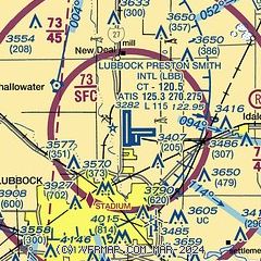
| Sectional chart |
|---|
|
CAUTION: Diagram may not be current
 Download PDF
of official airport diagram from the FAA
| Airport distance calculator |
|---|
|
|
| Sunrise and sunset |
|---|
|
Times for 29-May-2026
| | Local
(UTC-5) | | Zulu
(UTC) |
|---|
| Morning civil twilight | | 06:11 | | 11:11 |
| Sunrise | | 06:40 | | 11:40 |
| Sunset | | 20:49 | | 01:49 |
| Evening civil twilight | | 21:18 | | 02:18 |
|
| Current date and time |
|---|
| Zulu (UTC) | 30-May-2026 01:58:12 |
|---|
| Local (UTC-5) | 29-May-2026 20:58:12 |
|---|
|
| METAR |
|---|
| KLBB | 300153Z 18011KT 10SM FEW070 BKN200 28/12 A2984 RMK AO2 SLP052 CB DSNT NE T02830117
|
|
| TAF |
|---|
| KLBB | 292023Z 2920/3018 18011KT P6SM FEW040 BKN150 FM300300 16016KT P6SM BKN150 FM301300 22015KT P6SM SCT110
|
|
| NOTAMs |
|---|
NOTAMs are issued by the DoD/FAA and will open in a separate window not controlled by AirNav.
|
|


