FAA INFORMATION EFFECTIVE 22 JANUARY 2026
Location
| FAA Identifier: | 1H8 |
| Lat/Long: | 39-18-09.0330N 088-00-14.6230W
39-18.150550N 088-00.243717W
39.3025092,-88.0040619
(estimated) |
| Elevation: | 654.9 ft. / 199.6 m (surveyed) |
| Variation: | 03W (2010) |
| From city: | 1 mile NW of CASEY, IL |
| Time zone: | UTC -6 (UTC -5 during Daylight Saving Time) |
| Zip code: | 62420 |
Airport Operations
| Airport use: | Open to the public |
| Activation date: | 03/1947 |
| Control tower: | no |
| ARTCC: | INDIANAPOLIS CENTER |
| FSS: | SAINT LOUIS FLIGHT SERVICE STATION |
| NOTAMs facility: | STL (NOTAM-D service available) |
| Attendance: | MON-SAT 0800-1700 |
| Pattern altitude: | 1454.9 ft. MSL |
| Wind indicator: | lighted |
| Segmented circle: | yes |
| Lights: | MIRL RY 04/22 PRESET ON LOW INTST; TO INCR INTST & ACTVT TWY LGTS - CTAF. |
| Beacon: | white-green (lighted land airport)
Operates sunset to sunrise. |
Airport Communications
| CTAF/UNICOM: | 122.8 |
| HULMAN APPROACH: | 125.45 |
| HULMAN DEPARTURE: | 125.45 |
| WX ASOS at MTO (17 nm NW): | 118.475 (217-234-8442) |
Nearby radio navigation aids
| VOR radial/distance | | VOR name | | Freq | | Var |
|---|
| BIBr041/31.9 | | BIBLE GROVE VORTAC | | 109.00 | | 03E |
| TTHr250/36.8 | | TERRE HAUTE VORTAC | | 115.30 | | 02E |
| NDB name | | Hdg/Dist | | Freq | | Var | | ID |
|---|
| OLNEY | | 016/35.9 | | 272 | | 03W | | OLY | --- .-.. -.-- |
| SHELBYVILLE | | 101/39.4 | | 365 | | 02W | | SYZ | ... -.-- --.. |
Airport Services
| Fuel available: | 100LL |
| Parking: | hangars and tiedowns |
| Airframe service: | MAJOR |
| Powerplant service: | MAJOR |
Runway Information
Runway 4/22
| Dimensions: | 4001 x 75 ft. / 1220 x 23 m |
| Surface: | asphalt, in good condition |
| Weight bearing capacity: | |
| Runway edge lights: | medium intensity |
| RUNWAY 4 | | RUNWAY 22 |
| Latitude: | 39-17.875515N | | 39-18.387873N |
| Longitude: | 088-00.459773W | | 087-59.926187W |
| Elevation: | 653.1 ft. | | 654.4 ft. |
| Traffic pattern: | left | | right |
| Runway heading: | 042 magnetic, 039 true | | 222 magnetic, 219 true |
| Markings: | nonprecision, in good condition | | nonprecision, in good condition |
| Runway end identifier lights: | no | | no |
| Touchdown point: | yes, no lights | | yes, no lights |
Runway 18/36
| Dimensions: | 1943 x 75 ft. / 592 x 23 m |
| Surface: | turf, in good condition |
| Runway edge markings: | DSPLCD THR MKD WITH WHITE GRAVEL IN SHAPE OF 'L' ON RY EDGES. |
| RUNWAY 18 | | RUNWAY 36 |
| Latitude: | 39-18.349955N | | 39-18.029890N |
| Longitude: | 088-00.346787W | | 088-00.341182W |
| Elevation: | 654.9 ft. | | 649.4 ft. |
| Traffic pattern: | right | | left |
| Runway heading: | 182 magnetic, 179 true | | 002 magnetic, 359 true |
| Displaced threshold: | 297 ft. | | no |
| Runway end identifier lights: | no | | no |
| Touchdown point: | yes, no lights | | yes, no lights |
| Obstructions: | 16 ft. road, 5 ft. from runway
APCH RATIO 20:1 TO DSPLCD THR. | | none |
Airport Ownership and Management from official FAA records
| Ownership: | Publicly-owned |
| Owner: | CITY OF CASEY
PO BOX 425
CASEY, IL 62420
Phone 217-932-2700 |
| Manager: | CHRIS WHITE
2624 E WASHINGTON STREET
CASEY, IL 62420
Phone 908-247-1000
OR 908-247-1000 |
Additional Remarks
| A58-04 | RWY 4 & 22 HAVE SEASONAL CROPS PENTG PART 77 SFC |
| - | FOR CD CTC HULMAN APCH AT 812-877-7581. |
Instrument Procedures
NOTE: All procedures below are presented as PDF files. If you need a reader for these files, you should download the free Adobe Reader.NOT FOR NAVIGATION. Please procure official charts for flight.
FAA instrument procedures published for use from 22 January 2026 at 0901Z to 19 February 2026 at 0900z.
IAPs - Instrument Approach Procedures |
|---|
| RNAV (GPS) RWY 04 | |
download (191KB) |
| RNAV (GPS) RWY 22 | |
download (189KB) |
| NOTE: Special Take-Off Minimums/Departure Procedures apply | |
download (201KB) |
Other nearby airports with instrument procedures:
KMTO - Coles County Memorial Airport (17 nm NW)
KRSV - Crawford County Airport (24 nm SE)
KSIV - Sullivan County Airport (28 nm SE)
1H2 - Effingham County Regional Airport (28 nm SW)
KPRG - Edgar County Airport (28 nm NE)
|
|

Road maps at:
MapQuest
Bing
Google
| Aerial photo |
|---|
WARNING: Photo may not be current or correct
 Photo by David Newcomer
looking southwest
Photo by David Newcomer
looking southwest
Do you have a better or more recent aerial photo of Casey Municipal Airport that you would like to share? If so, please send us your photo.
|
| Sectional chart |
|---|
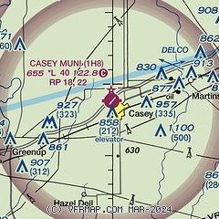
|
| Airport distance calculator |
|---|
|
|
| Sunrise and sunset |
|---|
|
Times for 16-Feb-2026
| | Local
(UTC-6) | | Zulu
(UTC) |
|---|
| Morning civil twilight | | 06:16 | | 12:16 |
| Sunrise | | 06:44 | | 12:44 |
| Sunset | | 17:29 | | 23:29 |
| Evening civil twilight | | 17:56 | | 23:56 |
|
| Current date and time |
|---|
| Zulu (UTC) | 16-Feb-2026 22:11:18 |
|---|
| Local (UTC-6) | 16-Feb-2026 16:11:18 |
|---|
|
| METAR |
|---|
KMTO
16nm NW | 162153Z AUTO 17009KT 10SM CLR 14/05 A3000 RMK AO2 SLP161 T01440050
|
KRSV
24nm SE | 162155Z AUTO 18010KT 10SM CLR 15/07 A3004 RMK AO2
|
K1H2
28nm SW | 162155Z AUTO 16007KT 10SM CLR 15/02 A3004 RMK AO2 T01500023 TSNO
|
KPRG
29nm NE | 162155Z AUTO 20013KT 10SM CLR 15/07 A3002 RMK AO2 T01500072
|
|
| TAF |
|---|
KHUF
32nm E | 161725Z 1618/1718 17006KT P6SM SCT250 FM170200 21007KT P6SM FEW250 TEMPO 1709/1713 3SM BR FM171400 18006KT P6SM BKN200
|
|
| NOTAMs |
|---|
NOTAMs are issued by the DoD/FAA and will open in a separate window not controlled by AirNav.
|
|

