FAA INFORMATION EFFECTIVE 19 FEBRUARY 2026
Location
| FAA Identifier: | 1H2 |
| Lat/Long: | 39-04-13.6000N 088-32-00.7000W
39-04.226667N 088-32.011667W
39.0704444,-88.5335278
(estimated) |
| Elevation: | 585.2 ft. / 178.4 m (surveyed) |
| Variation: | 01W (1995) |
| From city: | 3 miles S of EFFINGHAM, IL |
| Time zone: | UTC -6 (UTC -5 during Daylight Saving Time) |
| Zip code: | 62401 |
Airport Operations
| Airport use: | Open to the public |
| Activation date: | 10/1945 |
| Control tower: | no |
| ARTCC: | KANSAS CITY CENTER |
| FSS: | SAINT LOUIS FLIGHT SERVICE STATION |
| NOTAMs facility: | 1H2 (NOTAM-D service available) |
| Attendance: | 0800-1700 |
| Wind indicator: | lighted |
| Segmented circle: | no |
| Lights: | DUSK-DAWN. ACTVT REIL RWY 11 & 29; PSIL RWY 01 & 19; MIRL RWY 01/19, MIRL RWY 11/29 PRESET LOW INTST, TO INCR INTST & ACTVT - CTAF. |
| Beacon: | white-green (lighted land airport)
Operates sunset to sunrise. |
Airport Communications
| CTAF/UNICOM: | 122.725 |
| WX AWOS-3PT: | 118.375 (217-536-5976) |
- APCH/DEP SVC PRVDD BY KANSAS CITY ARTCC ON FREQS 124.3/269.15 (DECATUR RCAG).
Nearby radio navigation aids
| VOR radial/distance | | VOR name | | Freq | | Var |
|---|
| BIBr342/9.3 | | BIBLE GROVE VORTAC | | 109.00 | | 03E |
| NDB name | | Hdg/Dist | | Freq | | Var | | ID |
|---|
| SHELBYVILLE | | 146/24.8 | | 365 | | 02W | | SYZ | ... -.-- --.. |
| OLNEY | | 324/27.0 | | 272 | | 03W | | OLY | --- .-.. -.-- |
Airport Services
| Fuel available: | 100LL JET-A |
| Parking: | hangars and tiedowns |
| Airframe service: | MAJOR |
| Powerplant service: | MAJOR |
| Bottled oxygen: | NONE |
| Bulk oxygen: | NONE |
Runway Information
Runway 11/29
| Dimensions: | 5103 x 100 ft. / 1555 x 30 m |
| Surface: | concrete, in good condition |
| Runway edge lights: | medium intensity |
| RUNWAY 11 | | RUNWAY 29 |
| Latitude: | 39-04.415053N | | 39-04.086622N |
| Longitude: | 088-32.479062W | | 088-31.486415W |
| Elevation: | 585.2 ft. | | 572.1 ft. |
| Traffic pattern: | left | | left |
| Runway heading: | 114 magnetic, 113 true | | 294 magnetic, 293 true |
| Markings: | nonprecision, in fair condition | | nonprecision, in fair condition |
| Runway end identifier lights: | yes | | yes |
| Touchdown point: | yes, no lights | | yes, no lights |
| Instrument approach: | | | LOC/DME |
Runway 1/19
| Dimensions: | 3400 x 60 ft. / 1036 x 18 m |
| Surface: | asphalt, in good condition |
| Weight bearing capacity: | |
| Runway edge lights: | medium intensity |
| RUNWAY 1 | | RUNWAY 19 |
| Latitude: | 39-03.913358N | | 39-04.468532N |
| Longitude: | 088-32.101410W | | 088-32.007360W |
| Elevation: | 571.8 ft. | | 580.4 ft. |
| Traffic pattern: | left | | left |
| Runway heading: | 008 magnetic, 007 true | | 188 magnetic, 187 true |
| Markings: | nonprecision, in fair condition | | basic, in fair condition |
| Visual slope indicator: | pulsating/steady burning VASI on left (4.00 degrees glide path)
RY 01 PVASI UNUSBL BYD 5 DEG LEFT & RIGHT OF CRS. | | pulsating/steady burning VASI on left (3.50 degrees glide path)
RY 19 PVASI UNUSBL BYD 7 DEG LEFT & RIGHT OF CRS. |
| Touchdown point: | yes, no lights | | yes, no lights |
| Obstructions: | none | | 32 ft. tree, 840 ft. from runway, 20:1 slope to clear |
Airport Ownership and Management from official FAA records
| Ownership: | Publicly-owned |
| Owner: | EFFINGHAM COUNTY BOARD
307 N 3RD ST
EFFINGHAM, IL 62401
Phone 217-342-9291 |
| Manager: | JERRY TATE
14449 E 1100TH AVE
EFFINGHAM, IL 62401
Phone 217-536-5312 |
Additional Remarks
| - | TREE & SILO R TRSN AREA TREE L TRSN AREA RY 19. |
| - | FOR CD CTC KANSAS CITY ARTCC AT 913-254-8508. |
Instrument Procedures
NOTE: All procedures below are presented as PDF files. If you need a reader for these files, you should download the free Adobe Reader.NOT FOR NAVIGATION. Please procure official charts for flight.
FAA instrument procedures published for use from 19 February 2026 at 0901Z to 19 March 2026 at 0900Z.
IAPs - Instrument Approach Procedures |
|---|
| RNAV (GPS) RWY 01 **CHANGED** | |
download (218KB) |
| RNAV (GPS) RWY 11 **CHANGED** | |
download (201KB) |
| RNAV (GPS) RWY 29 **CHANGED** | |
download (242KB) |
| NOTE: Special Alternate Minimums apply | |
download (163KB) |
| NOTE: Special Take-Off Minimums/Departure Procedures apply | |
download (484KB) |
Other nearby airports with instrument procedures:
KFOA - Flora Municipal Airport (25 nm S)
2H0 - Shelby County Airport (25 nm NW)
KOLY - Olney-Noble Airport (27 nm SE)
KMTO - Coles County Memorial Airport (27 nm NE)
1H8 - Casey Municipal Airport (28 nm NE)
|
|

Road maps at:
MapQuest
Bing
Google
| Aerial photo |
|---|
WARNING: Photo may not be current or correct
 Photo taken 10-Nov-2005
Do you have a better or more recent aerial photo of Effingham County Regional Airport that you would like to share? If so, please send us your photo.
|
| Sectional chart |
|---|
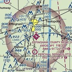
|
| Airport distance calculator |
|---|
|
|
| Sunrise and sunset |
|---|
|
Times for 04-Mar-2026
| | Local
(UTC-6) | | Zulu
(UTC) |
|---|
| Morning civil twilight | | 05:57 | | 11:57 |
| Sunrise | | 06:23 | | 12:23 |
| Sunset | | 17:49 | | 23:49 |
| Evening civil twilight | | 18:15 | | 00:15 |
|
| Current date and time |
|---|
| Zulu (UTC) | 04-Mar-2026 13:52:03 |
|---|
| Local (UTC-6) | 04-Mar-2026 07:52:03 |
|---|
|
| METAR |
|---|
| K1H2 | 041335Z AUTO 10004KT 1 1/2SM +RA OVC006 12/12 A3012 RMK AO2 P0019 T01200120
|
|
| TAF |
|---|
KMVN
48nm S | 041132Z 0412/0512 VRB04KT 5SM BR VCSH BKN050 FM041800 20009G17KT P6SM BKN020 TEMPO 0420/0424 4SM -TSRA BKN020CB FM050000 19005KT P6SM VCSH BKN040 PROB30 0500/0506 5SM -SHRA BR FM050600 18005KT 5SM -SHRA BR OVC015
|
KDEC
48nm N | 041131Z 0412/0512 06008KT 2SM -SHRA BR OVC004 FM041700 07008KT 2SM BR OVC004 TEMPO 0419/0422 1SM -TSRA BR OVC004CB FM042200 06006KT 3SM BR VCSH OVC005 FM050200 VRB03KT 1/2SM -SHRA FG OVC003 PROB30 0507/0512 1SM -TSRA BR OVC003CB
|
|
| NOTAMs |
|---|
NOTAMs are issued by the DoD/FAA and will open in a separate window not controlled by AirNav.
|
|

