FAA INFORMATION EFFECTIVE 27 NOVEMBER 2025
Location
| FAA Identifier: | OLY |
| Lat/Long: | 38-43-18.5780N 088-10-35.1580W
38-43.309633N 088-10.585967W
38.7218272,-88.1764328
(estimated) |
| Elevation: | 482.1 ft. / 146.9 m (surveyed) |
| Variation: | 03W (2020) |
| From city: | 4 miles W of OLNEY-NOBLE, IL |
| Time zone: | UTC -6 (UTC -5 during Daylight Saving Time) |
| Zip code: | 62868 |
Airport Operations
| Airport use: | Open to the public |
| Control tower: | no |
| ARTCC: | KANSAS CITY CENTER |
| FSS: | SAINT LOUIS FLIGHT SERVICE STATION |
| NOTAMs facility: | OLY (NOTAM-D service available) |
| Attendance: | 0800-1700
FOR ARPT ATTENDANCE AFTER HRS CALL 618-393-2967. |
| Wind indicator: | lighted |
| Segmented circle: | yes |
| Lights: | ACTVT REIL RWY 04 & 11; PAPI RWY 11; MIRL RWY 04/22, MIRL RWY 11/29 PRESET ON LOW INTST - TO INCR INTST & ACTVT - CTAF. |
| Beacon: | white-green (lighted land airport)
Operates sunset to sunrise. |
Airport Communications
| CTAF/UNICOM: | 123.0 |
| WX AWOS-3: | 119.275 (618-393-4416) |
| WX AWOS-3 at FOA (13 nm W): | 120.175 (618-662-8355) |
- APCH/DEP SVC PRVDD BY KANSAS CITY ARTCC (ZKC) ON FREQS 124.3/269.15 (DECATUR RCAG).
- (E94) SAWRS WEATHER STATION.
Nearby radio navigation aids
| VOR radial/distance | | VOR name | | Freq | | Var |
|---|
| BIBr127/18.6 | | BIBLE GROVE VORTAC | | 109.00 | | 03E |
| NDB name | | Hdg/Dist | | Freq | | Var | | ID |
|---|
| OLNEY | | at field | | 272 | | 03W | | OLY | --- .-.. -.-- |
| WAYNE COUNTY | | 029/23.2 | | 257 | | 01W | | FWC | ..-. .-- -.-. |
Airport Services
| Fuel available: | 100LL JET-A+
100LL:100LL & A+ AVBL 24 HRS WITH CREDIT CARD. |
| Parking: | hangars and tiedowns |
| Airframe service: | MAJOR |
| Powerplant service: | MAJOR |
| Bottled oxygen: | NONE |
| Bulk oxygen: | NONE |
Runway Information
Runway 11/29
| Dimensions: | 4099 x 75 ft. / 1249 x 23 m |
| Surface: | asphalt, in good condition |
| Weight bearing capacity: | |
| Runway edge lights: | medium intensity |
| RUNWAY 11 | | RUNWAY 29 |
| Latitude: | 38-43.475617N | | 38-43.276705N |
| Longitude: | 088-11.068397W | | 088-10.244608W |
| Elevation: | 482.0 ft. | | 468.4 ft. |
| Traffic pattern: | left | | left |
| Runway heading: | 110 magnetic, 107 true | | 290 magnetic, 287 true |
| Markings: | nonprecision, in good condition | | basic, in good condition |
| Visual slope indicator: | 2-light PAPI on left (3.00 degrees glide path) | | 2-light PAPI on left (3.50 degrees glide path) |
| Runway end identifier lights: | yes | | no |
| Touchdown point: | yes, no lights | | yes, no lights |
| Instrument approach: | LOC/DME | | |
| Obstructions: | 12 ft. road, 460 ft. from runway, 285 ft. right of centerline, 21:1 slope to clear | | 47 ft. tree, 1147 ft. from runway, 157 ft. left of centerline, 20:1 slope to clear |
Runway 4/22
| Dimensions: | 3598 x 60 ft. / 1097 x 18 m |
| Surface: | asphalt, in good condition |
| Weight bearing capacity: | | Single wheel: | 18.0 | | Double wheel: | 25.0 |
|
| Runway edge lights: | medium intensity |
| RUNWAY 4 | | RUNWAY 22 |
| Latitude: | 38-42.993295N | | 38-43.473578N |
| Longitude: | 088-10.727513W | | 088-10.284125W |
| Elevation: | 464.6 ft. | | 471.8 ft. |
| Traffic pattern: | left | | left |
| Runway heading: | 038 magnetic, 035 true | | 218 magnetic, 215 true |
| Markings: | nonprecision, in good condition | | basic, in good condition |
| Runway end identifier lights: | yes | | no |
| Touchdown point: | yes, no lights | | yes, no lights |
Airport Ownership and Management from official FAA records
| Ownership: | Publicly-owned |
| Owner: | OLNEY-NOBLE APT AUTH
4395 NORTH AIRPORT RD
NOBLE, IL 62868
Phone 618-395-2686 |
| Manager: | THOMAS D. BAKER
4395 N AIRPORT RD
NOBLE, IL 62868
Phone 618-393-2967 |
Additional Remarks
| - | FOR CD CTC KANSAS CITY ARTCC AT 913-254-8508. |
Instrument Procedures
NOTE: All procedures below are presented as PDF files. If you need a reader for these files, you should download the free Adobe Reader.NOT FOR NAVIGATION. Please procure official charts for flight.
FAA instrument procedures published for use from 27 November 2025 at 0901Z to 25 December 2025 at 0900Z.
IAPs - Instrument Approach Procedures |
|---|
| RNAV (GPS) RWY 04 | |
download (212KB) |
| RNAV (GPS) RWY 11 | |
download (219KB) |
| LOC RWY 11 | |
download (224KB) |
| NDB RWY 04 | |
download (190KB) |
| NOTE: Special Alternate Minimums apply | |
download (141KB) |
| NOTE: Special Take-Off Minimums/Departure Procedures apply | |
download (430KB) |
Other nearby airports with instrument procedures:
KFOA - Flora Municipal Airport (13 nm W)
KAJG - Mount Carmel Municipal Airport (22 nm E)
KFWC - Fairfield Municipal Airport (23 nm SW)
1H2 - Effingham County Regional Airport (27 nm NW)
KLWV - Lawrenceville-Vincennes International Airport (27 nm E)
|
|

Road maps at:
MapQuest
Bing
Google
| Aerial photo |
|---|
WARNING: Photo may not be current or correct
 Photo taken 04-May-2008
Do you have a better or more recent aerial photo of Olney-Noble Airport that you would like to share? If so, please send us your photo.
|
| Sectional chart |
|---|
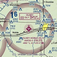
|
| Airport distance calculator |
|---|
|
|
| Sunrise and sunset |
|---|
|
Times for 13-Dec-2025
| | Local
(UTC-6) | | Zulu
(UTC) |
|---|
| Morning civil twilight | | 06:33 | | 12:33 |
| Sunrise | | 07:03 | | 13:03 |
| Sunset | | 16:31 | | 22:31 |
| Evening civil twilight | | 17:00 | | 23:00 |
|
| Current date and time |
|---|
| Zulu (UTC) | 13-Dec-2025 14:35:58 |
|---|
| Local (UTC-6) | 13-Dec-2025 08:35:58 |
|---|
|
| METAR |
|---|
| KOLY | 131350Z AUTO 34006KT 7SM OVC012 M01/M03 A3022 RMK AO2 T10131031
|
KFOA
13nm W | 131415Z AUTO 36007KT 4SM BR OVC010 M01/M03 A3022 RMK AO2
|
|
| TAF |
|---|
KMVN
41nm SW | 131428Z 1314/1412 31011G16KT P6SM BKN012 TEMPO 1314/1317 3SM BR OVC009 FM131700 34014G21KT 5SM -DZ BR OVC008 PROB30 1318/1322 5SM -SN -FZDZ FM140300 34012G18KT P6SM BKN012 FM140500 01015G24KT P6SM OVC250
|
|
| NOTAMs |
|---|
NOTAMs are issued by the DoD/FAA and will open in a separate window not controlled by AirNav.
|
|

