FAA INFORMATION EFFECTIVE 11 JUNE 2026
Location
| FAA Identifier: | AJG |
| Lat/Long: | 38-36-23.5000N 087-43-36.1000W
38-36.391667N 087-43.601667W
38.6065278,-87.7266944
(estimated) |
| Elevation: | 429.4 ft. / 130.9 m (surveyed) |
| Variation: | 02W (2000) |
| From city: | 12 miles N of MOUNT CARMEL, IL |
| Time zone: | UTC -5 (UTC -6 during Standard Time) |
| Zip code: | 62460 |
Airport Operations
| Airport use: | Open to the public |
| Activation date: | 01/1948 |
| Control tower: | no |
| ARTCC: | INDIANAPOLIS CENTER |
| FSS: | SAINT LOUIS FLIGHT SERVICE STATION |
| NOTAMs facility: | AJG (NOTAM-D service available) |
| Attendance: | 0800-1700 |
| Wind indicator: | lighted |
| Segmented circle: | yes |
| Lights: | ACTVT REIL RWY 04, 13, 22 & 31; PVASI RWY 04, 13, 22 & 31; MIRL RWY 13/31- CTAF. MIRL RWY 04/22 PRESET ON LOW INTST TO INCR INTST - CTAF. |
| Beacon: | white-green (lighted land airport)
Operates sunset to sunrise. |
Airport Communications
| CTAF/UNICOM: | 122.7 |
| WX AWOS-3: | 134.900 (618-948-2184) |
| EVANSVILLE APPROACH: | 125.6 [0530-2230] |
| EVANSVILLE DEPARTURE: | 125.6 [0530-2230] |
| WX ASOS at LWV (11 nm NE): | 118.0 (618-943-5252) |
- APCH/DEP SVC PRVDD BY INDIANAPOLIS ARTCC ON FREQS 128.3/291.625 (EVANSVILLE RCAG) WHEN EVANSVILLE APCH CTL CLSD.
Nearby radio navigation aids
| NDB name | | Hdg/Dist | | Freq | | Var | | ID |
|---|
| OLNEY | | 111/21.9 | | 272 | | 03W | | OLY | --- .-.. -.-- |
| WAYNE COUNTY | | 068/34.8 | | 257 | | 01W | | FWC | ..-. .-- -.-. |
Airport Services
| Fuel available: | 100LL JET-A |
| Parking: | hangars and tiedowns |
| Airframe service: | MINOR |
| Powerplant service: | MINOR |
| Bottled oxygen: | NONE |
| Bulk oxygen: | NONE |
Runway Information
Runway 13/31
| Dimensions: | 4500 x 75 ft. / 1372 x 23 m |
| Surface: | asphalt, in good condition |
| Weight bearing capacity: | | PCN 21 /F/D/X/T | | Single wheel: | 54.5 | | Double wheel: | 71.0 |
|
| Runway edge lights: | medium intensity |
| RUNWAY 13 | | RUNWAY 31 |
| Latitude: | 38-36.653080N | | 38-36.169313N |
| Longitude: | 087-44.033270W | | 087-43.317662W |
| Elevation: | 426.6 ft. | | 429.2 ft. |
| Traffic pattern: | left | | left |
| Runway heading: | 133 magnetic, 131 true | | 313 magnetic, 311 true |
| Markings: | nonprecision, in good condition | | nonprecision, in good condition |
| Visual slope indicator: | pulsating/steady burning VASI on left (3.00 degrees glide path)
PVASI UNUSBL BYD 5 DEG LEFT & RIGHT OF CNTRLN. | | pulsating/steady burning VASI on left (3.00 degrees glide path)
PVASI UNUSBL BYD 5 DEG LEFT & RIGHT OF CNTRLN. |
| Runway end identifier lights: | yes | | yes |
| Touchdown point: | yes, no lights | | yes, no lights |
Runway 4/22
| Dimensions: | 4000 x 100 ft. / 1219 x 30 m |
| Surface: | asphalt, in fair condition |
| Weight bearing capacity: | | PCN 16 /F/D/X/T | | Single wheel: | 40.5 | | Double wheel: | 54.0 |
|
| Runway edge lights: | medium intensity |
| RUNWAY 4 | | RUNWAY 22 |
| Latitude: | 38-36.121830N | | 38-36.620800N |
| Longitude: | 087-43.793895W | | 087-43.245777W |
| Elevation: | 428.3 ft. | | 428.5 ft. |
| Traffic pattern: | left | | left |
| Runway heading: | 043 magnetic, 041 true | | 223 magnetic, 221 true |
| Markings: | nonprecision, in good condition | | nonprecision, in good condition |
| Visual slope indicator: | pulsating/steady burning VASI on left (3.00 degrees glide path)
PVASI UNUSBL BYD 5 DEG LEFT & RIGHT OF CNTRLN. | | pulsating/steady burning VASI on left (3.00 degrees glide path)
PVASI UNUSBL BYD 5 DEG LEFT & RIGHT OF CNTRLN. |
| Runway end identifier lights: | yes | | yes |
| Touchdown point: | yes, no lights | | yes, no lights |
Airport Ownership and Management from official FAA records
| Ownership: | Publicly-owned |
| Owner: | CITY OF MT CARMEL
CITY HALL 631 N. MARKET ST
MT CARMEL, IL 62863
Phone 618-262-4822 |
| Manager: | LUIS GARCIA
10188 MT CARMEL AIRPORT LN
ST FRANCISVILLE, IL 62460
Phone 618-948-2413
EMAIL ADDRESS: AJGAIRPORT@GMAIL.COM (ALL LOWER CASE) |
Additional Remarks
| - | SELF SVC FUEL AVBL H24 WITH CREDIT CARD. |
| - | FOR CD CTC EVANSVILLE APCH AT 812-436-4690, WHEN APCH CLSD CTC INDIANAPOLIS ARTCC AT 317-247-2411. |
Instrument Procedures
NOTE: All procedures below are presented as PDF files. If you need a reader for these files, you should download the free Adobe Reader.NOT FOR NAVIGATION. Please procure official charts for flight.
FAA instrument procedures published for use from 11 June 2026 at 0901Z to 09 July 2026 at 0900z.
IAPs - Instrument Approach Procedures |
|---|
| RNAV (GPS) RWY 04 | |
download (202KB) |
| RNAV (GPS) RWY 22 | |
download (210KB) |
| RNAV (GPS) RWY 31 | |
download (203KB) |
| NOTE: Special Take-Off Minimums/Departure Procedures apply | |
download (270KB) |
Other nearby airports with instrument procedures:
KLWV - Lawrenceville-Vincennes International Airport (11 nm NE)
KOLY - Olney-Noble Airport (22 nm W)
KRSV - Crawford County Airport (25 nm N)
KDCY - Daviess County Airport (28 nm E)
KSIV - Sullivan County Airport (33 nm NE)
|
|

Road maps at:
MapQuest
Bing
Google
| Aerial photo |
|---|
WARNING: Photo may not be current or correct

Do you have a better or more recent aerial photo of Mount Carmel Municipal Airport that you would like to share? If so, please send us your photo.
|
| Sectional chart |
|---|
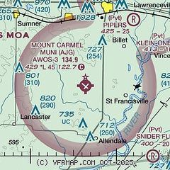
|
| Airport distance calculator |
|---|
|
|
| Sunrise and sunset |
|---|
|
Times for 05-Jul-2026
| | Local
(UTC-5) | | Zulu
(UTC) |
|---|
| Morning civil twilight | | 05:02 | | 10:02 |
| Sunrise | | 05:33 | | 10:33 |
| Sunset | | 20:18 | | 01:18 |
| Evening civil twilight | | 20:49 | | 01:49 |
|
| Current date and time |
|---|
| Zulu (UTC) | 05-Jul-2026 19:10:02 |
|---|
| Local (UTC-5) | 05-Jul-2026 14:10:02 |
|---|
|
| METAR |
|---|
| KAJG | 051855Z AUTO 31005KT 10SM SCT035 SCT046 30/24 A2995 RMK AO2 T03010244
|
KLWV
11nm NE | 051853Z AUTO 33010KT 10SM CLR 28/22 A2995 RMK AO2 SLP136 T02830222
|
|
| TAF |
|---|
KEVV
35nm S | 051730Z 0518/0618 27006KT P6SM SCT035 BKN150 TEMPO 0520/0523 3SM TSRA BKN025CB FM060000 VRB03KT P6SM SCT040 BKN150 TEMPO 0609/0613 5SM BR FM061300 34004KT 6SM BR BKN015 FM061600 34005KT P6SM BKN035
|
KHNB
42nm SE | 051720Z 0518/0618 22005KT P6SM SCT018 BKN025 FM051900 23005KT P6SM BKN040 PROB30 0520/0524 3SM -TSRA BKN050CB FM060000 33003KT P6SM SCT050 FM060800 00000KT 3SM BR BKN005 FM061300 34004KT P6SM BKN015
|
|
| NOTAMs |
|---|
NOTAMs are issued by the DoD/FAA and will open in a separate window not controlled by AirNav.
|
|

