FAA INFORMATION EFFECTIVE 09 JULY 2026
Location
| FAA Identifier: | 1O4 |
| Lat/Long: | 35-44-01.2000N 098-43-49.9000W
35-44.020000N 098-43.831667W
35.7336667,-98.7305278
(estimated) |
| Elevation: | 1732.5 ft. / 528.1 m (surveyed) |
| Variation: | 05E (2015) |
| From city: | 1 mile SE of THOMAS, OK |
| Time zone: | UTC -5 (UTC -6 during Standard Time) |
| Zip code: | 73669 |
Airport Operations
| Airport use: | Open to the public |
| Control tower: | no |
| ARTCC: | FORT WORTH CENTER |
| FSS: | MC ALESTER FLIGHT SERVICE STATION |
| NOTAMs facility: | MLC (NOTAM-D service available) |
| Attendance: | MON-FRI 0800-1700 |
| Wind indicator: | lighted |
| Segmented circle: | no |
| Lights: | MIRL RWY 17/35 ON SS-SR PRESET LOW INTST; INCR/DECR INTST - CTAF. PAPI RWY 17 & 35 ON CONSLY. |
| Beacon: | white-green (lighted land airport)
Operates sunset to sunrise. |
Airport Communications
| CTAF: | 122.9 |
| WX AWOS-3PT at OJA (12 nm S): | 118.575 (580-772-7020) |
| WX AWOS-3 at CLK (15 nm SW): | 119.225 (580-323-8477) |
| WX AWOS-3 at JWG (17 nm NE): | 134.175 (580-623-7388) |
- APCH/DEP CTL SVC PRVDD BY FORT WORTH ARTCC (ZFW) ON FREQS 128.4/269.375 (CLINTON-SHERMAN RCAG).
Nearby radio navigation aids
| VOR radial/distance | | VOR name | | Freq | | Var |
|---|
| BFVr033/37.8 | | BURNS FLAT VORTAC | | 110.00 | | 05E |
Airport Services
| Fuel available: | 100LL JET-A+
100LL:AVBL 24 HRS SELF SVC WITH CREDIT CARD.
A+:AVBL 24 HRS SELF SVC WITH CREDIT CARD. |
| Parking: | tiedowns |
| Airframe service: | NONE |
| Powerplant service: | NONE |
| Bottled oxygen: | NONE |
| Bulk oxygen: | NONE |
Runway Information
Runway 17/35
| Dimensions: | 3771 x 60 ft. / 1149 x 18 m |
| Surface: | asphalt, in good condition |
| Weight bearing capacity: | |
| Runway edge lights: | medium intensity |
| RUNWAY 17 | | RUNWAY 35 |
| Latitude: | 35-44.330472N | | 35-43.709005N |
| Longitude: | 098-43.833797W | | 098-43.830440W |
| Elevation: | 1731.8 ft. | | 1732.4 ft. |
| Traffic pattern: | left | | right |
| Runway heading: | 175 magnetic, 180 true | | 355 magnetic, 360 true |
| Displaced threshold: | 212 ft. | | no |
| Markings: | nonprecision, in good condition | | nonprecision, in good condition |
| Visual slope indicator: | 2-light PAPI on left (3.00 degrees glide path)
PAPI UNUSBL BYD 8 DEGS RIGHT OF CNTRLN. | | 2-light PAPI on left (3.00 degrees glide path) |
| Touchdown point: | yes, no lights | | yes, no lights |
| Obstructions: | 18 ft. road, 338 ft. from runway, 7:1 slope to clear
30:1 OBS CLC SLOPE TO DTHR. | | none |
Airport Ownership and Management from official FAA records
| Ownership: | Publicly-owned |
| Owner: | CITY OF THOMAS
CITY HALL, P. O. BOX 250
THOMAS, OK 73669
Phone 580-603-2636 |
| Manager: | RODNEY WILSON
P. O. BOX 250, P. O. BOX 641
THOMAS, OK 73669
Phone 580-603-2636 |
Additional Remarks
| - | FOR CD CTC FORT WORTH ARTCC AT 817-858-7584. |
| - | OVNGT HNGR SPACE, COURTESY CAR, OTR SVCS,CTC AMGR 580-603-2636. |
Instrument Procedures
NOTE: All procedures below are presented as PDF files. If you need a reader for these files, you should download the free Adobe Reader.NOT FOR NAVIGATION. Please procure official charts for flight.
FAA instrument procedures published for use from 09 July 2026 at 0901Z to 06 August 2026 at 0900Z.
IAPs - Instrument Approach Procedures |
|---|
| RNAV (GPS) RWY 17 | |
download (177KB) |
| RNAV (GPS) RWY 35 | |
download (185KB) |
| NOTE: Special Take-Off Minimums/Departure Procedures apply | |
download |
Other nearby airports with instrument procedures:
KOJA - Weatherford Stafford Airport (12 nm S)
KCLK - Clinton Regional Airport (15 nm SW)
KJWG - Watonga Regional Airport (17 nm NE)
2O8 - Hinton Municipal Airport (23 nm SE)
KCSM - Infinity One Oklahoma Spaceport Airport (33 nm SW)
|
|

Road maps at:
MapQuest
Bing
Google
| Aerial photo |
|---|

|
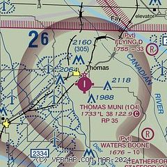
| Sectional chart |
|---|
|
| Airport distance calculator |
|---|
|
|
| Sunrise and sunset |
|---|
|
Times for 25-Jul-2026
| | Local
(UTC-5) | | Zulu
(UTC) |
|---|
| Morning civil twilight | | 06:10 | | 11:10 |
| Sunrise | | 06:38 | | 11:38 |
| Sunset | | 20:44 | | 01:44 |
| Evening civil twilight | | 21:13 | | 02:13 |
|
| Current date and time |
|---|
| Zulu (UTC) | 25-Jul-2026 23:29:26 |
|---|
| Local (UTC-5) | 25-Jul-2026 18:29:26 |
|---|
|
| METAR |
|---|
KOJA
12nm S | 252310Z AUTO 16013KT 10SM CLR 39/19 A2996 RMK AO2 T03860193
|
KCLK
16nm SW | 252315Z AUTO 17010G16KT 10SM CLR 38/16 A2996 RMK AO2
|
KJWG
17nm NE | 252315Z AUTO 17009KT 10SM CLR 38/19 A2997 RMK AO2 T03790191
|
|
| TAF |
|---|
KCSM
32nm SW | 251720Z 2518/2618 20015G22KT P6SM SKC FM252100 18015KT P6SM SCT080 SCT280 FM260100 16010KT P6SM SCT280 FM261000 20010KT P6SM SCT280 FM261400 22010G25KT P6SM SCT280
|
|
| NOTAMs |
|---|
NOTAMs are issued by the DoD/FAA and will open in a separate window not controlled by AirNav.
|
|

