FAA INFORMATION EFFECTIVE 09 JULY 2026
Location
| FAA Identifier: | 22N |
| Lat/Long: | 40-48-34.2320N 075-45-41.3870W
40-48.570533N 075-45.689783W
40.8095089,-75.7614964
(estimated) |
| Elevation: | 534 ft. / 162.8 m (surveyed) |
| Variation: | 12W (2000) |
| From city: | 3 miles SW of LEHIGHTON, PA |
| Time zone: | UTC -4 (UTC -5 during Standard Time) |
| Zip code: | 18235 |
Airport Operations
| Airport use: | Open to the public |
| Activation date: | 12/1964 |
| Control tower: | no |
| ARTCC: | NEW YORK CENTER |
| FSS: | WILLIAMSPORT FLIGHT SERVICE STATION |
| NOTAMs facility: | IPT (NOTAM-D service available) |
| Attendance: | 0800-DUSK |
| Wind indicator: | lighted |
| Segmented circle: | yes |
| Lights: | ACTVT REIL RWY 08 & 26; PAPI RWY 08 & 26; MIRL RWY 08/26 - CTAF. |
| Beacon: | white-green (lighted land airport)
Operates sunset to sunrise. |
Airport Communications
| CTAF/UNICOM: | 123.05 |
| WX AWOS-3PT: | 119.350 (570-386-3423) |
| ALLENTOWN APPROACH: | 119.65 ;3000 FT & BLW 124.45 ;ABV 3000 FT |
| ALLENTOWN DEPARTURE: | 119.65 ;3000 FT & BLW 124.45 ;ABV 3000 FT |
| IC: | 119.65 ;3000 FT & BLW 124.45 ;ABV 3000 FT |
| WX AWOS-3 at HZL (15 nm NW): | 119.975 (570-459-4901) |
| WX ASOS at ABE (17 nm SE): | 126.975 (610-477-0813) |
| WX AWOS-3 at XLL (19 nm SE): | 127.875 (610-231-3111) |
Nearby radio navigation aids
| VOR radial/distance | | VOR name | | Freq | | Var |
|---|
| ETXr355/14.2 | | EAST TEXAS VOR/DME | | 110.20 | | 09W |
| FJCr300/14.8 | | ALLENTOWN VORTAC | | 117.50 | | 10W |
| LVZr197/28.0 | | WILKES-BARRE VORTAC | | 111.60 | | 10W |
| PTWr354/36.4 | | POTTSTOWN VORTAC | | 116.50 | | 09W |
Airport Services
| Fuel available: | 100LL JET-A |
| Parking: | hangars and tiedowns |
| Airframe service: | MAJOR |
| Powerplant service: | MAJOR |
| Bottled oxygen: | NONE |
| Bulk oxygen: | NONE |
Runway Information
Runway 8/26
| Dimensions: | 3000 x 60 ft. / 914 x 18 m |
| Surface: | asphalt, in good condition |
| Weight bearing capacity: | |
| Runway edge lights: | medium intensity |
| RUNWAY 8 | | RUNWAY 26 |
| Latitude: | 40-48.482283N | | 40-48.659950N |
| Longitude: | 075-45.992717W | | 075-45.385917W |
| Elevation: | 532.0 ft. | | 507.0 ft. |
| Traffic pattern: | left | | left |
| Runway heading: | 081 magnetic, 069 true | | 261 magnetic, 249 true |
| Markings: | nonprecision, in good condition | | nonprecision, in good condition |
| Visual slope indicator: | 2-light PAPI on left (3.00 degrees glide path) | | 2-light PAPI on left (3.00 degrees glide path) |
| Runway end identifier lights: | yes | | yes |
| Touchdown point: | yes, no lights | | yes, no lights |
| Obstructions: | 48 ft. tree, 763 ft. from runway, 298 ft. left of centerline, 11:1 slope to clear
11 FT BRUSH, 163 FT FM RWY END, 90 FT R. | | 76 ft. trees, 441 ft. from runway, 267 ft. left of centerline, 3:1 slope to clear |
Airport Ownership and Management from official FAA records
| Ownership: | Publicly-owned |
| Owner: | CARBON COUNTY AIRPORT AUTHORITY
2321 MAHONING DR EAST
LEHIGHTON, PA 18235
Phone 570-386-5025 |
| Manager: | PAUL SMITH
2321 MAHONING DRIVE EAST
LEHIGHTON, PA 18235
Phone 570-778-4783
FOR ASST AFTER HRS CTC 570-778-4783. |
Additional Remarks
| - | DEER AND GEESE ON AND IN VICINITY OF ARPT. |
| - | 24 HR SELF SERVE 100LL AND JET A |
| - | FOR CD CTC ALLENTOWN APCH AT 800-728-6322. |
| - | COLD TEMPERATURE AIRPORT. ALTITUDE CORRECTION REQUIRED AT OR BELOW -22C. |
Instrument Procedures
NOTE: All procedures below are presented as PDF files. If you need a reader for these files, you should download the free Adobe Reader.NOT FOR NAVIGATION. Please procure official charts for flight.
FAA instrument procedures published for use from 09 July 2026 at 0901Z to 06 August 2026 at 0900Z.
IAPs - Instrument Approach Procedures |
|---|
| RNAV (GPS) RWY 08 | |
download (204KB) |
| RNAV (GPS) RWY 26 | |
download (223KB) |
| NOTE: Special Alternate Minimums apply | |
download (122KB) |
| NOTE: Special Take-Off Minimums/Departure Procedures apply | |
download (428KB) |
Other nearby airports with instrument procedures:
KHZL - Hazleton Regional Airport (15 nm NW)
KABE - Lehigh Valley International Airport (17 nm SE)
KXLL - Allentown Queen City Municipal Airport (19 nm SE)
N43 - Braden Airpark (24 nm E)
KMPO - Pocono Mountains Regional Airport (26 nm NE)
|
|

Road maps at:
MapQuest
Bing
Google
| Aerial photo |
|---|
WARNING: Photo may not be current or correct
 Taken early July 2006
Do you have a better or more recent aerial photo of Jake Arner Memorial Airport that you would like to share? If so, please send us your photo.
|
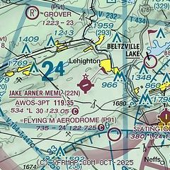
| Sectional chart |
|---|
|
| Airport distance calculator |
|---|
|
|
| Sunrise and sunset |
|---|
|
Times for 14-Jul-2026
| | Local
(UTC-4) | | Zulu
(UTC) |
|---|
| Morning civil twilight | | 05:12 | | 09:12 |
| Sunrise | | 05:45 | | 09:45 |
| Sunset | | 20:33 | | 00:33 |
| Evening civil twilight | | 21:06 | | 01:06 |
|
| Current date and time |
|---|
| Zulu (UTC) | 14-Jul-2026 22:33:35 |
|---|
| Local (UTC-4) | 14-Jul-2026 18:33:35 |
|---|
|
| METAR |
|---|
| K22N | 142215Z AUTO 28004KT 10SM CLR 32/17 A2999 RMK AO2
|
KHZL
15nm NW | 142215Z AUTO 26003KT 7SM CLR 29/19 A3008 RMK AO2
|
KABE
17nm SE | 142151Z 24014G25KT 10SM CLR 33/19 A2997 RMK AO2 SLP145 T03280194
|
KXLL
19nm SE | 142215Z AUTO 25015G20KT 10SM CLR 32/20 A2999 RMK AO2 TSNO
|
|
| TAF |
|---|
KABE
17nm SE | 141727Z 1418/1518 25012G18KT P6SM BKN300 FM150000 24008KT P6SM SCT300 FM150500 26006KT P6SM FEW250 WS020/30035KT FM151100 25005KT P6SM FEW250
|
|
| NOTAMs |
|---|
NOTAMs are issued by the DoD/FAA and will open in a separate window not controlled by AirNav.
|
|

