FAA INFORMATION EFFECTIVE 27 NOVEMBER 2025
Location
| FAA Identifier: | 2F0 |
| Lat/Long: | 30-54-22.4000N 101-53-23.3000W
30-54.373333N 101-53.388333W
30.9062222,-101.8898056
(estimated) |
| Elevation: | 2200 ft. / 671 m (estimated) |
| Variation: | 09E (1985) |
| From city: | 1 mile SE of IRAAN, TX |
| Time zone: | UTC -6 (UTC -5 during Daylight Saving Time) |
| Zip code: | 79744 |
Airport Operations
| Airport use: | Open to the public |
| Activation date: | 10/1946 |
| Control tower: | no |
| ARTCC: | HOUSTON CENTER |
| FSS: | SAN ANGELO FLIGHT SERVICE STATION |
| NOTAMs facility: | SJT (NOTAM-D service available) |
| Attendance: | UNATNDD |
| Wind indicator: | lighted |
| Segmented circle: | yes |
| Lights: | SS-SR |
| Beacon: | white-green (lighted land airport)
Operates sunset to sunrise. |
Airport Communications
Airport Services
| Fuel available: | 100LL
100LL:100LL 24 HR SELF-SERVE. |
| Parking: | tiedowns |
| Airframe service: | NONE |
| Powerplant service: | NONE |
| Bottled oxygen: | NONE |
| Bulk oxygen: | NONE |
Runway Information
Runway 14/32
| Dimensions: | 4085 x 60 ft. / 1245 x 18 m |
| Surface: | asphalt, in fair condition |
| Weight bearing capacity: | |
| Runway edge lights: | non-standard
NSTD FIXTURES, NOT FRANGIBLE, NSTD LAYOUT, NSTD COLORS. |
| RUNWAY 14 | | RUNWAY 32 |
| Traffic pattern: | left | | left |
| Displaced threshold: | 500 ft.
& 32 THRS DSPLCD NOT LGHTD, DAY OPNS ONLY. | | 490 ft. |
| Markings: | basic, in fair condition | | basic, in fair condition |
| Obstructions: | 37 ft. pline, marked and lighted, 201 ft. from runway
8 FT FENCE, 0 FT DIST 119 FT L/R. | | none
8 FT FENCE, 0 FT DIST,88 FT L/R. |
Runway 7/25
| Dimensions: | 2755 x 50 ft. / 840 x 15 m |
| Surface: | asphalt, in poor condition
LOOSE STONES, EXTSV CRACKING, POT HOLES ON CL. |
| Weight bearing capacity: | |
| Runway edge markings: | MRKGS FADED. |
| RUNWAY 7 | | RUNWAY 25 |
| Latitude: | 30-54.332083N | | 30-54.416257N |
| Longitude: | 101-53.646992W | | 101-53.128937W |
| Elevation: | 2198.0 ft. | | 2174.0 ft. |
| Traffic pattern: | left | | left |
| Runway heading: | 070 magnetic, 079 true | | 250 magnetic, 259 true |
| Markings: | basic, in poor condition | | basic, in poor condition |
| Obstructions: | 35 ft. pline, lighted, 365 ft. from runway, 155 ft. left and right of centerline, 4:1 slope to clear
16 FT POLE (WINDSOCK), 117 FT DSTC, 90 FT L. | | 10 ft. brush, 201 ft. from runway, 125 ft. left and right of centerline
8 FT FENCE 0 FT DIST, 69 FT L/R. |
Airport Ownership and Management from official FAA records
| Ownership: | Publicly-owned |
| Owner: | PECOS CO.
103 W. CALLAGHAN
FORT STOCKTON, TX 79735
Phone 432-336-2792 |
| Manager: | MICKEY JACK PERRY
1489 COUNTY LOOP ROAD 9219, PO BOX 456
IRAAN, TX 79744
Phone 432-639-2841
MGR CELL 432-208-2198. |
Additional Remarks
| - | WILDLIFE ON AND INVOF ARPT. |
| - | RISING TRRN SOUTHWEST AND WEST OF ARPT. |
| - | NSTD DSPLCD THR LGTS RWYS 14 & 32. |
| - | FOR CD CTC HOUSTON ARTCC AT 281-230-5622. |
| - | RWY 32, 15 FT DROP OFF AT RWY END. |
Instrument Procedures
There are no published instrument procedures at 2F0.
Some nearby airports with instrument procedures:
E41 - Reagan County Airport (28 nm NE)
KOZA - Ozona Municipal Airport (37 nm E)
KFST - Fort Stockton-Pecos County Airport (53 nm W)
KMAF - Midland International Air and Space Port Airport (64 nm N)
KODO - Odessa Airport-Schlemeyer Field (66 nm NW)
|
|

Road maps at:
MapQuest
Bing
Google
| Aerial photo |
|---|
WARNING: Photo may not be current or correct
 Photo taken 29-Jul-2011
looking north.
Photo taken 29-Jul-2011
looking north.
Do you have a better or more recent aerial photo of Iraan Municipal Airport that you would like to share? If so, please send us your photo.
|
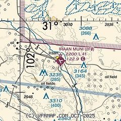
| Sectional chart |
|---|
|
| Airport distance calculator |
|---|
|
|
| Sunrise and sunset |
|---|
|
Times for 30-Nov-2025
| | Local
(UTC-6) | | Zulu
(UTC) |
|---|
| Morning civil twilight | | 07:02 | | 13:02 |
| Sunrise | | 07:28 | | 13:28 |
| Sunset | | 17:45 | | 23:45 |
| Evening civil twilight | | 18:11 | | 00:11 |
|
| Current date and time |
|---|
| Zulu (UTC) | 30-Nov-2025 17:01:32 |
|---|
| Local (UTC-6) | 30-Nov-2025 11:01:32 |
|---|
|
| METAR |
|---|
KE41
28nm NE | 301655Z AUTO 03011KT 10SM OVC029 01/M08 A3036 RMK AO2 T00121080
|
KOZA
37nm E | 301615Z AUTO 10SM OVC030 03/M05 A3037 RMK AO2
|
|
| NOTAMs |
|---|
NOTAMs are issued by the DoD/FAA and will open in a separate window not controlled by AirNav.
|
|


