FAA INFORMATION EFFECTIVE 11 JUNE 2026
Location
| FAA Identifier: | 39P |
| Lat/Long: | 46-33-01.2990N 122-15-59.8530W
46-33.021650N 122-15.997550W
46.5503608,-122.2666258
(estimated) |
| Elevation: | 941 ft. / 287 m (estimated) |
| Variation: | 20E (1985) |
| Time zone: | UTC -7 (UTC -8 during Standard Time) |
| Zip code: | 98356 |
Airport Operations
| Airport use: | Open to the public |
| Activation date: | 08/1964 |
| Control tower: | no |
| ARTCC: | SEATTLE CENTER |
| FSS: | SEATTLE FLIGHT SERVICE STATION |
| NOTAMs facility: | SEA (NOTAM-D service available) |
| Attendance: | UNATNDD |
| Wind indicator: | lighted |
| Segmented circle: | no |
| Lights: | ACTVT MIRL RY 07/25 - CTAF. |
| Beacon: | white-green (lighted land airport)
ACTVT ROTG BCN - CTAF. |
Airport Communications
Nearby radio navigation aids
| VOR radial/distance | | VOR name | | Freq | | Var |
|---|
| OLMr115/36.3 | | OLYMPIA VORTAC | | 113.40 | | 19E |
Airport Services
| Parking: | tiedowns |
| Airframe service: | NONE |
| Powerplant service: | NONE |
Runway Information
Runway 7/25
| Dimensions: | 1810 x 40 ft. / 552 x 12 m |
| Surface: | asphalt/L
WDSPR RAVELLING AND ALLIGATOR CRACKING. |
| Runway edge lights: | medium intensity |
| Runway edge markings: | MARKINGS FADED. |
| RUNWAY 7 | | RUNWAY 25 |
| Latitude: | 46-33.022283N | | 46-33.021000N |
| Longitude: | 122-16.213367W | | 122-15.781733W |
| Traffic pattern: | left | | left |
| Runway heading: | 070 magnetic, 090 true | | 250 magnetic, 270 true |
| Displaced threshold: | 200 ft. | | no |
| Markings: | basic, in poor condition | | basic, in poor condition |
| Obstructions: | 50 ft. pline, 324 ft. from runway, 2:1 slope to clear
+3 FT FENCE AT 35 FT FM THR AND 32 FT R; GUARD RAIL AND ROAD 98 FT FM THR; 15 FT SIGN, 18 FT R, 65 FT FM THR; TREE, 51 FT HIGH, 2 FT R, 120 FT FM THR, 10 FT SIGN 84 FT L, 30 FT FM THR; FENCE 102 FT L, 15 FT FM THR; ROAD 120 FT L. | | none
RWY 25 +2 FT ROAD AND GUARD RAIL AT 15 FT FM THR; TREE, 15 FT HIGH, 49 FT R, 74 FT FM THR; POLE, 4 FT HIGH, 79 FT R, 8 FT FM THR. |
Airport Ownership and Management from official FAA records
| Ownership: | Publicly-owned |
| Owner: | CITY OF MORTON
PO BOX 1089
MORTON, WA 98356
Phone 360-496-6881 |
| Manager: | ANDERS POLLMAN
PO BOX 1089, PO BOX 1089
MORTON, WA 98356
Phone (360) 496-5210
PUB. WKS. SUP. |
Additional Remarks
| - | TREES NEAR RWY. |
| - | TREES, STREAM, AND BRUSH IN PRIM SFC. |
| - | DEER AND ELK ON & INVOF RWY. |
| - | DITCH PARL RWY ON EASTSIDE. |
| - | FOR CD CTC SEATTLE ARTCC AT 253-351-3694. |
| - | SLP ON N SIDE ON RWY MID-FIELD BGNG AT SHOULDER. |
Instrument Procedures
There are no published instrument procedures at 39P.
Some nearby airports with instrument procedures:
KTDO - Ed Carlson Memorial Field/South Lewis County Airport (23 nm W)
KCLS - Chehalis-Centralia Airport (30 nm W)
KPLU - Pierce County Airport/Thun Field (33 nm N)
KGRF - Gray Army Airfield (Joint Base Lewis-McChord) (34 nm N)
KOLM - Olympia Regional Airport (36 nm NW)
|
|

Road maps at:
MapQuest
Bing
Google
| Aerial photo |
|---|
WARNING: Photo may not be current or correct
 Photo taken 01-Sep-2012
looking west.
Photo taken 01-Sep-2012
looking west.
Do you have a better or more recent aerial photo of Strom Field Airport that you would like to share? If so, please send us your photo.
|
| Sectional chart |
|---|
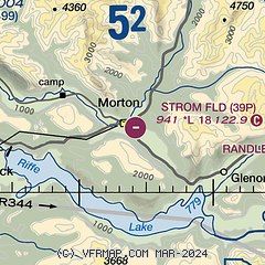
|
| Airport distance calculator |
|---|
|
|
| Sunrise and sunset |
|---|
|
Times for 03-Jul-2026
| | Local
(UTC-7) | | Zulu
(UTC) |
|---|
| Morning civil twilight | | 04:43 | | 11:43 |
| Sunrise | | 05:22 | | 12:22 |
| Sunset | | 21:04 | | 04:04 |
| Evening civil twilight | | 21:43 | | 04:43 |
|
| Current date and time |
|---|
| Zulu (UTC) | 04-Jul-2026 05:43:42 |
|---|
| Local (UTC-7) | 03-Jul-2026 22:43:42 |
|---|
|
| METAR |
|---|
KCLS
30nm W | 040515Z AUTO 00000KT 10SM CLR 15/15 A3010 RMK AO2
|
KPLU
33nm N | 040515Z AUTO 00000KT 9SM BKN035 BKN043 16/13 A3010 RMK AO2
|
KGRF
33nm N | 040455Z AUTO 25004KT 10SM FEW220 17/12 A3006 RMK AO2 SLP182 T01690118 $
|
KTCM
35nm N | 040455Z AUTO 26005KT 10SM CLR 17/12 A3008 RMK AO2 SLP189 T01730122 $
|
KOLM
36nm NW | 040454Z AUTO 10SM CLR 15/12 A3009 RMK AO2 SLP190 T01500117 $
|
KKLS
37nm SW | 040456Z AUTO 30006KT 10SM CLR 17/13 A3010 RMK AO2 SLP195 T01670128 PNO $
|
|
| TAF |
|---|
KTCM
35nm N | 032100Z 0321/0503 23009KT 9999 BKN035 QNH3009INS BECMG 0401/0402 25010G15KT 9999 BKN050 QNH3004INS BECMG 0409/0410 21006KT 9999 SCT010 BKN020 QNH3011INS BECMG 0413/0414 19006KT 9999 SCT015 BKN025 QNH3014INS BECMG 0418/0419 23010G15KT 9999 SCT030 QNH3016INS TX23/0400Z TN11/0413Z
|
KOLM
36nm NW | 031720Z 0318/0418 25006KT P6SM SCT030 OVC050 FM032100 25006KT P6SM OVC050 FM040600 20003KT P6SM OVC035 FM041400 21004KT P6SM BKN025 FM041700 23005KT P6SM BKN050
|
|
| NOTAMs |
|---|
NOTAMs are issued by the DoD/FAA and will open in a separate window not controlled by AirNav.
|
|

