FAA INFORMATION EFFECTIVE 09 JULY 2026
Location
| FAA Identifier: | 3F9 |
| Lat/Long: | 32-40-36.0299N 095-30-39.4492W
32-40.600498N 095-30.657487W
32.6766750,-95.5109581
(estimated) |
| Elevation: | 430 ft. / 131.1 m (surveyed) |
| Variation: | 02E (2020) |
| From city: | 1 mile W of MINEOLA, TX |
| Time zone: | UTC -5 (UTC -6 during Standard Time) |
| Zip code: | 75773 |
Airport Operations
| Airport use: | Open to the public |
| Activation date: | 07/1941 |
| Control tower: | no |
| ARTCC: | FORT WORTH CENTER |
| FSS: | FORT WORTH FLIGHT SERVICE STATION |
| NOTAMs facility: | FTW (NOTAM-D service available) |
| Attendance: | CONTINUOUS |
| Wind indicator: | yes |
| Segmented circle: | no |
| Lights: | ACTVT LIRL RWY 18L/36R - CTAF. |
| Beacon: | white-green (lighted land airport)
Operates sunset to sunrise. |
Airport Communications
| CTAF/UNICOM: | 122.8 |
| LONGVIEW APPROACH: | 128.75 [MIDLAND 0600-0000 SAN ANGELO 0600-2100] |
| LONGVIEW DEPARTURE: | 128.75 [MIDLAND 0600-0000 SAN ANGELO 0600-2100] |
| WX AWOS-3PT at JDD (4 nm N): | 118.9 (903-768-3065) |
- APCH/DEP SVC PRVDD BY FORT WORTH ARTCC (ZFW) ON FREQS 132.025/317.75 (CUMBY RCAG) WHEN LONGVIEW APCH CTL CLSD.
Nearby radio navigation aids
| VOR radial/distance | | VOR name | | Freq | | Var |
|---|
| TYRr338/20.0 | | TYLER VOR/DME | | 114.20 | | 06E |
| FZTr356/36.1 | | FRANKSTON VOR/DME | | 111.40 | | 06E |
| NDB name | | Hdg/Dist | | Freq | | Var | | ID |
|---|
| AMBASSADOR | | 278/20.8 | | 404 | | 07E | | ABG | .- -... --. |
Airport Services
| Fuel available: | 100LL
100LL:FUEL SELF-SVC. |
| Parking: | tiedowns |
| Airframe service: | MAJOR |
| Powerplant service: | MAJOR |
| Bottled oxygen: | NONE |
| Bulk oxygen: | NONE |
Runway Information
Runway 18L/36R
| Dimensions: | 3203 x 40 ft. / 976 x 12 m |
| Surface: | asphalt, in poor condition
RWY SFC LOOSE STONES & ROUGH PATCHES AT THRS. RWY SKED TO BE RESURFACED MID 2025 - MID 2026. EXP ARPT CLOSURE. |
| Weight bearing capacity: | |
| Runway edge lights: | low intensity
THR AT BOTH RWY ENDS MKD BY THREE RED LGTS EACH SIDE. |
| RUNWAY 18L | | RUNWAY 36R |
| Latitude: | 32-40.865033N | | 32-40.336967N |
| Longitude: | 095-30.644967W | | 095-30.651467W |
| Elevation: | 429.3 ft. | | 403.9 ft. |
| Traffic pattern: | left | | left |
| Runway heading: | 179 magnetic, 181 true | | 359 magnetic, 001 true |
| Markings: | basic, in good condition | | basic, in good condition |
| Touchdown point: | yes, no lights | | yes, no lights |
| Obstructions: | 80 ft. trees, 201 ft. from runway, 65 ft. right of centerline
4 FT FENCE, 15 FT RD AT THR ACRS APCH 5 FT DSTC. | | 80 ft. trees, 201 ft. from runway, 125 ft. left and right of centerline
15 FT RD, 4 FT FENCE AT THR. 80 FT TREES 60 FT DSTC 125 FT L. |
Runway 18R/36L
| Dimensions: | 3234 x 60 ft. / 986 x 18 m |
| Surface: | turf, in good condition |
| RUNWAY 18R | | RUNWAY 36L |
| Latitude: | 32-40.866667N | | 32-40.333333N |
| Longitude: | 095-30.666667W | | 095-30.666667W |
| Elevation: | 429.0 ft. | | 430.0 ft. |
| Traffic pattern: | left | | left |
| Runway heading: | 178 magnetic, 180 true | | 358 magnetic, 000 true |
| Markings: | none, in good condition | | none, in good condition |
| Touchdown point: | yes, no lights | | yes, no lights |
| Obstructions: | 80 ft. trees, 90 ft. right of centerline | | 50 ft. trees, 124 ft. left of centerline |
Airport Ownership and Management from official FAA records
| Ownership: | Privately-owned |
| Owner: | R. H. WISENER
P.O. BOX 65
MINEOLA, TX 75773-0065
Phone 903-569-1929 |
| Manager: | LUPITA A. WISENER
1412 COUNTRY CLUB DRIVE
MINEOLA, TX 75773-1419
Phone 903-569-1929
AMGR LIVES ADJ. |
Additional Remarks
| - | FOR CD CTC FORT WORTH ARTCC AT 817-858-7584. |
| A51-36R | MKD THR DSPLCD 140 FT. |
| A51-18L | RWY 18L & 36R THRS DSPLCD 140 FT. |
Instrument Procedures
There are no published instrument procedures at 3F9.
Some nearby airports with instrument procedures:
KJDD - Wood County Airport/Collins Field (4 nm N)
F51 - Winnsboro Municipal Airport (20 nm NE)
KTYR - Tyler Pounds Regional Airport (20 nm S)
KJXI - Fox Stephens Field/Gilmer Municipal Airport (28 nm E)
07F - Gladewater Municipal Airport (29 nm E)
|
|

Road maps at:
MapQuest
Bing
Google
| Aerial photo |
|---|
WARNING: Photo may not be current or correct

Do you have a better or more recent aerial photo of Mineola Airport-Wisener Field that you would like to share? If so, please send us your photo.
|
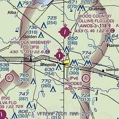
| Sectional chart |
|---|
|
| Airport distance calculator |
|---|
|
|
| Sunrise and sunset |
|---|
|
Times for 18-Jul-2026
| | Local
(UTC-5) | | Zulu
(UTC) |
|---|
| Morning civil twilight | | 06:00 | | 11:00 |
| Sunrise | | 06:28 | | 11:28 |
| Sunset | | 20:29 | | 01:29 |
| Evening civil twilight | | 20:56 | | 01:56 |
|
| Current date and time |
|---|
| Zulu (UTC) | 18-Jul-2026 13:00:00 |
|---|
| Local (UTC-5) | 18-Jul-2026 08:00:00 |
|---|
|
| METAR |
|---|
KJDD
4nm N | 181235Z AUTO VRB04KT 9SM CLR 25/24 A3010 RMK AO2 T02500239 $
|
KTYR
19nm S | 181253Z 21007KT 10SM BKN011 26/24 A3013 RMK AO2 SLP195 T02610244
|
|
| TAF |
|---|
KTYR
19nm S | 181120Z 1812/1912 17005KT P6SM BKN250 FM181300 21007KT P6SM SCT010 SCT150 BKN250 FM181500 22010KT P6SM SCT020 SCT150 BKN250 FM182100 19010KT P6SM SCT040 BKN250 FM190000 17006KT P6SM BKN250 FM190600 19005KT P6SM BKN250
|
|
| NOTAMs |
|---|
NOTAMs are issued by the DoD/FAA and will open in a separate window not controlled by AirNav.
|
|


