FAA INFORMATION EFFECTIVE 27 NOVEMBER 2025
Location
| FAA Identifier: | 3LF |
| Lat/Long: | 39-09-45.0000N 089-40-28.7000W
39-09.750000N 089-40.478333W
39.1625000,-89.6746389
(estimated) |
| Elevation: | 690.5 ft. / 210.5 m (surveyed) |
| Variation: | 01E (1990) |
| From city: | 2 miles SW of LITCHFIELD, IL |
| Time zone: | UTC -6 (UTC -5 during Daylight Saving Time) |
| Zip code: | 62056 |
Airport Operations
| Airport use: | Open to the public |
| Control tower: | no |
| ARTCC: | KANSAS CITY CENTER |
| FSS: | SAINT LOUIS FLIGHT SERVICE STATION |
| NOTAMs facility: | 3LF (NOTAM-D service available) |
| Attendance: | 0800-1700 |
| Wind indicator: | lighted |
| Segmented circle: | yes |
| Lights: | ACTVT REIL RWY 09, 27, 18 & 36; PAPI RWY 09, 27, 18 & 36; MIRL RWY 09/27 & 18/36; TWY LGTS - CTAF. MIRL RWY 18/36 & TWY C PRESET ON LOW INTST, TO INCR INTST & ACTVT - CTAF. |
| Beacon: | white-green (lighted land airport)
Operates sunset to sunrise. |
Airport Communications
| CTAF/UNICOM: | 122.8 |
| WX AWOS-3PT: | 118.175 (217-324-4735) |
| SAINT LOUIS APPROACH: | 124.2 |
| SAINT LOUIS DEPARTURE: | 124.2 |
Nearby radio navigation aids
| VOR radial/distance | | VOR name | | Freq | | Var |
|---|
| TOYr020/27.8 | | TROY VORTAC | | 116.00 | | 04E |
Airport Services
| Fuel available: | 100LL JET-A
A:SELF SERV 100 LL FUEL AVAILABLE 24 HOURS. |
| Parking: | hangars and tiedowns |
| Airframe service: | MAJOR |
| Powerplant service: | MAJOR |
Runway Information
Runway 18/36
| Dimensions: | 4002 x 75 ft. / 1220 x 23 m |
| Surface: | asphalt, in good condition |
| Runway edge lights: | medium intensity |
| RUNWAY 18 | | RUNWAY 36 |
| Latitude: | 39-09.794273N | | 39-09.135013N |
| Longitude: | 089-40.341735W | | 089-40.338323W |
| Elevation: | 685.3 ft. | | 680.0 ft. |
| Traffic pattern: | right | | left |
| Runway heading: | 178 magnetic, 179 true | | 358 magnetic, 359 true |
| Markings: | nonprecision, in fair condition | | nonprecision, in fair condition |
| Visual slope indicator: | 2-light PAPI on left (3.00 degrees glide path) | | 2-light PAPI on left (3.00 degrees glide path) |
| Runway end identifier lights: | yes | | yes |
| Touchdown point: | yes, no lights | | yes, no lights |
Runway 9/27
| Dimensions: | 3900 x 75 ft. / 1189 x 23 m |
| Surface: | asphalt, in good condition |
| Runway edge lights: | medium intensity |
| RUNWAY 9 | | RUNWAY 27 |
| Latitude: | 39-10.041572N | | 39-10.041303N |
| Longitude: | 089-41.033020W | | 089-40.207672W |
| Elevation: | 681.9 ft. | | 689.9 ft. |
| Traffic pattern: | right | | left |
| Runway heading: | 089 magnetic, 090 true | | 269 magnetic, 270 true |
| Markings: | nonprecision, in good condition | | nonprecision, in good condition |
| Visual slope indicator: | 2-light PAPI on left (3.00 degrees glide path) | | 2-light PAPI on left (3.00 degrees glide path) |
| Runway end identifier lights: | yes | | yes |
| Touchdown point: | yes, no lights | | yes, no lights |
| Obstructions: | 14 ft. road, 464 ft. from runway, 289 ft. left of centerline, 18:1 slope to clear
APCH RATIO 33:1 TO RY END FM OVER C.O. | | none |
Airport Ownership and Management from official FAA records
| Ownership: | Publicly-owned |
| Owner: | LITCHFIELD ARPT AUTH
1201 US ROUTE 66 SOUTH, P.O. BOX 381
LITCHFIELD, IL 62056
Phone 217-324-6507
BILL FLEMING, CHAIRMAN. |
| Manager: | NICHOLAS WEATHERFORD
1201US ROUTE 66 SOUTH, P.O. BOX 381
LITCHFIELD, IL 62056
Phone 217-556-4299
EMAIL ADDRESS: AIRPORT@LITCHFIELDIL.COM (ALL LOWER CASE) |
Additional Remarks
| - | AEROBATIC AREA 1700 FT - 4200 FT MSL ABOVE ARPT. |
| - | FOR CD CTC ST LOUIS APCH AT 314-890-1017. |
Instrument Procedures
NOTE: All procedures below are presented as PDF files. If you need a reader for these files, you should download the free Adobe Reader.NOT FOR NAVIGATION. Please procure official charts for flight.
FAA instrument procedures published for use from 27 November 2025 at 0901Z to 25 December 2025 at 0900Z.
IAPs - Instrument Approach Procedures |
|---|
| RNAV (GPS) RWY 09 | |
download (225KB) |
| RNAV (GPS) RWY 18 | |
download (244KB) |
| RNAV (GPS) RWY 27 | |
download (215KB) |
| RNAV (GPS) RWY 36 | |
download (239KB) |
| NOTE: Special Alternate Minimums apply | |
download (61KB) |
| NOTE: Special Take-Off Minimums/Departure Procedures apply | |
download (411KB) |
Other nearby airports with instrument procedures:
KALN - St Louis Regional Airport (24 nm SW)
KGRE - Greenville Airport (24 nm SE)
KVLA - Vandalia Municipal Airport (26 nm SE)
KTAZ - Taylorville Municipal Airport (27 nm NE)
KBLV - Scott Air Force Base/MidAmerica Airport (38 nm S)
|
|

Road maps at:
MapQuest
Bing
Google
| Aerial photo |
|---|
WARNING: Photo may not be current or correct
 Photo by Ginger Kleinschnittger
Photo taken 31-Aug-2009
Photo by Ginger Kleinschnittger
Photo taken 31-Aug-2009
Do you have a better or more recent aerial photo of Litchfield Municipal Airport that you would like to share? If so, please send us your photo.
|
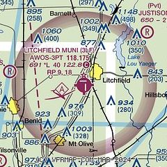
| Sectional chart |
|---|
|
| Airport distance calculator |
|---|
|
|
| Sunrise and sunset |
|---|
|
Times for 06-Dec-2025
| | Local
(UTC-6) | | Zulu
(UTC) |
|---|
| Morning civil twilight | | 06:35 | | 12:35 |
| Sunrise | | 07:05 | | 13:05 |
| Sunset | | 16:35 | | 22:35 |
| Evening civil twilight | | 17:05 | | 23:05 |
|
| Current date and time |
|---|
| Zulu (UTC) | 06-Dec-2025 19:11:57 |
|---|
| Local (UTC-6) | 06-Dec-2025 13:11:57 |
|---|
|
| METAR |
|---|
| K3LF | 061855Z AUTO 15004KT 10SM CLR 03/M02 A2996 RMK AO2 T00311016
|
|
| TAF |
|---|
KBLV
38nm S | 061600Z 0616/0722 VRB04KT 9999 FEW200 QNH2988INS BECMG 0622/0623 14006KT 9999 BKN030 BKN120 QNH2986INS BECMG 0705/0706 16009KT 9000 -SHRA BKN010 OVC035 620502 QNH2984INS BECMG 0710/0711 28006KT 9999 NSW BKN012 OVC040 620403 QNH2988INS BECMG 0717/0718 32010G15KT 9999 BKN020 OVC040 620205 QNH2996INS TX08/0621Z TN02/0716Z
|
KSTL
41nm SW | 061724Z 0618/0724 15004KT P6SM SCT200 FM070800 19005KT P6SM BKN050 OVC100 TEMPO 0710/0714 P6SM BKN010 FM071400 35010G20KT 6SM -DZ OVC007
|
KSPI
41nm N | 061723Z 0618/0718 VRB03KT P6SM BKN250 FM070400 14007KT P6SM OVC050 PROB30 0705/0707 5SM -RA OVC025 FM070700 15007KT 5SM -RA BR OVC016 FM071000 17008KT 4SM BR VCSH OVC007 FM071400 35009KT 4SM BR BKN005
|
KCPS
42nm SW | 061724Z 0618/0718 23005KT P6SM FEW025 OVC250 FM070800 19005KT P6SM BKN050 OVC100 TEMPO 0710/0714 P6SM OVC008 FM071400 35010G20KT 6SM -DZ OVC007
|
|
| NOTAMs |
|---|
NOTAMs are issued by the DoD/FAA and will open in a separate window not controlled by AirNav.
|
|

