FAA INFORMATION EFFECTIVE 27 NOVEMBER 2025
Location
| FAA Identifier: | 4G8 |
| Lat/Long: | 41-19-07.2487N 081-57-37.5906W
41-19.120812N 081-57.626510W
41.3186802,-81.9604418
(estimated) |
| Elevation: | 810.7 ft. / 247.1 m (surveyed) |
| Variation: | 06W (1985) |
| From city: | 1 mile NW of COLUMBIA STATION, OH |
| Time zone: | UTC -5 (UTC -4 during Daylight Saving Time) |
| Zip code: | 44028 |
Airport Operations
| Airport use: | Open to the public |
| Activation date: | 09/1955 |
| Control tower: | no |
| ARTCC: | CLEVELAND CENTER |
| FSS: | CLEVELAND FLIGHT SERVICE STATION |
| NOTAMs facility: | CLE (NOTAM-D service available) |
| Attendance: | IREG |
| Wind indicator: | yes |
| Segmented circle: | no |
| Lights: | NSTD LIRL RWY 18/36 OTS INDEFLY. |
Airport Communications
| CTAF/UNICOM: | 122.8 |
| WX ASOS at CLE (7 nm NE): | PHONE 216-264-9022 |
| WX ASOS at LPR (10 nm W): | 118.925 (440-323-7088) |
| WX ASOS at BKL (17 nm NE): | PHONE 216-241-6904 |
Nearby radio navigation aids
| VOR radial/distance | | VOR name | | Freq | | Var |
|---|
| DJBr110/9.4 | | DRYER VOR/DME | | 113.60 | | 05W |
| ACOr294/36.5 | | AKRON VOR/DME | | 114.40 | | 04W |
| CXRr257/37.8 | | CHARDON VOR/DME | | 112.70 | | 05W |
Airport Services
| Parking: | hangars and tiedowns |
Runway Information
Runway 18/36
| Dimensions: | 3152 x 40 ft. / 961 x 12 m |
| Surface: | asphalt, in fair condition |
| Runway edge lights: | non-standard
NSTD LIRL DUE TO MISG THR LGTS. |
| Runway edge markings: | NSTD NRS ONLY DUE TO NO DTHR MKGS, NO ARROWHEADS; NORTH 300 FT UNMKD. |
| Operational restrictions: | CLSD DLY SS-SR. |
| RUNWAY 18 | | RUNWAY 36 |
| Latitude: | 41-19.380280N | | 41-18.861343N |
| Longitude: | 081-57.619128W | | 081-57.633892W |
| Elevation: | 809.5 ft. | | 810.1 ft. |
| Traffic pattern: | left | | left |
| Runway heading: | 187 magnetic, 181 true | | 007 magnetic, 001 true |
| Displaced threshold: | 300 ft. | | 209 ft. |
| Markings: | NSTD, in fair condition | | NSTD, in fair condition |
| Touchdown point: | yes, no lights | | yes, no lights |
| Obstructions: | 35 ft. trees, 201 ft. from runway, 130 ft. both sides of centerline
35 FT TREES, 0 FT DIST, 130 FT B. | | 60 ft. tree, 450 ft. from runway, 25 ft. right of centerline, 4:1 slope to clear
OBSTN CLNC SLP 11:1 TO DTHR. |
Airport Ownership and Management from official FAA records
| Ownership: | Privately-owned |
| Owner: | COLUMBIA ENTERPRISES, INC
27410 ROYALTON RD
COLUMBIA STATION, OH 44028-9159
Phone 440-236-8800 |
| Manager: | DAVID SAVILLE
PO BOX 599
COLUMBIA STATION, OH 44028-0599
Phone 757-510-6788
4G8COLUMBIAAIRPORT@GMAIL.COM. |
Additional Remarks
| A30A-36 | CALM WIND RWY. |
| - | FOR CD CTC CLEVELAND APCH AT 216-352-2323. |
Instrument Procedures
There are no published instrument procedures at 4G8.
Some nearby airports with instrument procedures:
1G1 - Elyria Airport (6 nm W)
KCLE - Cleveland-Hopkins International Airport (7 nm NE)
KLPR - Lorain County Regional Airport (10 nm W)
1G5 - Medina Municipal Airport (14 nm SE)
KBKL - Burke Lakefront Airport (17 nm NE)
|
|

Road maps at:
MapQuest
Bing
Google
| Aerial photo |
|---|
WARNING: Photo may not be current or correct

Do you have a better or more recent aerial photo of Columbia Airport that you would like to share? If so, please send us your photo.
|
| Sectional chart |
|---|
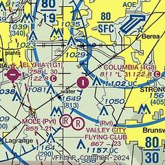
|
| Airport distance calculator |
|---|
|
|
| Sunrise and sunset |
|---|
|
Times for 17-Dec-2025
| | Local
(UTC-5) | | Zulu
(UTC) |
|---|
| Morning civil twilight | | 07:18 | | 12:18 |
| Sunrise | | 07:49 | | 12:49 |
| Sunset | | 16:59 | | 21:59 |
| Evening civil twilight | | 17:30 | | 22:30 |
|
| Current date and time |
|---|
| Zulu (UTC) | 17-Dec-2025 14:19:20 |
|---|
| Local (UTC-5) | 17-Dec-2025 09:19:20 |
|---|
|
| METAR |
|---|
KCLE
8nm NE | 171351Z 22013KT 10SM OVC170 04/M03 A2985 RMK AO2 SLP131 T00441033 $
|
KLPR
10nm W | 171353Z AUTO 24014KT 10SM CLR 04/M03 A2989 RMK AO2 SLP127 T00391028
|
KBKL
18nm NE | 171353Z 22016G24KT 10SM SCT110 05/M03 A2987 RMK AO2 PK WND 20026/1318 SLP118 T00501028
|
|
| TAF |
|---|
KCLE
8nm NE | 171138Z 1712/1818 24012G22KT P6SM SCT090 BKN250 FM171800 27010KT P6SM SCT250 FM172200 VRB04KT P6SM SCT250 FM180300 18010KT P6SM SCT250 FM180900 18012G23KT P6SM BKN090 BKN250 WS020/20040KT FM181500 18018G30KT P6SM SCT050 BKN090 WS020/21050KT
|
|
| NOTAMs |
|---|
NOTAMs are issued by the DoD/FAA and will open in a separate window not controlled by AirNav.
|
|


