FAA INFORMATION EFFECTIVE 30 OCTOBER 2025
Location
| FAA Identifier: | 4M0 |
| Lat/Long: | 44-41-46.1500N 085-54-50.5750W
44-41.769167N 085-54.842917W
44.6961528,-85.9140486
(estimated) |
| Elevation: | 820 ft. / 250 m (estimated) |
| From city: | 12 miles W of TRAVERSE CITY, MI |
| Time zone: | UTC -5 (UTC -4 during Daylight Saving Time) |
| Zip code: | 49643 |
Airport Operations
| Airport use: | Open to the public |
| Activation date: | 08/1998 |
| Control tower: | no |
| ARTCC: | MINNEAPOLIS CENTER |
| FSS: | LANSING FLIGHT SERVICE STATION |
| NOTAMs facility: | LAN (NOTAM-D service available) |
| Attendance: | UNATNDD |
| Wind indicator: | yes |
| Segmented circle: | no |
Airport Communications
| CTAF: | 122.9 |
| WX AWOS-3P at FKS (13 nm W): | 118.325 (231-352-7573) |
| WX ASOS at TVC (14 nm E): | PHONE 231-486-2920 |
Nearby radio navigation aids
| VOR radial/distance | | VOR name | | Freq | | Var |
|---|
| TVCr278/15.6 | | TRAVERSE CITY VOR/DME | | 114.60 | | 02W |
Airport Services
Runway Information
Runway 9/27
| Dimensions: | 2537 x 100 ft. / 773 x 30 m |
| Surface: | turf, in good condition |
| Runway edge markings: | RWY & DTHR MKD WITH 3 FT YELLOW CONES. |
| RUNWAY 9 | | RUNWAY 27 |
| Latitude: | 44-41.770000N | | 44-41.768333N |
| Longitude: | 085-55.135833W | | 085-54.550000W |
| Elevation: | 820.0 ft. | | 820.0 ft. |
| Traffic pattern: | left | | left |
| Runway heading: | 090 true | | 270 true |
| Displaced threshold: | 1000 ft. | | no |
| Obstructions: | 14 ft. road, 44 ft. from runway, 129 ft. left and right of centerline, 3:1 slope to clear
APCH RATIO 20:1 TO DTHR BASED ON STRAIGHT OUT OVR 92 FT TREES, 1840 FT DIST. | | 75 ft. trees, 125 ft. left and right of centerline
APCH RATIO 20:1 TO DTHR BASED ON STRAIGHT OUT OVR 88 FT TREES, 1760 FT DIST. |
Airport Ownership and Management from official FAA records
| Ownership: | Privately-owned |
| Owner: | KEITH DIEDRICK
10907 THIEL RD
TRAVERSE CITY, MI 49685-9298
Phone 231-463-7135 |
| Manager: | SHANE GRAY
4449 MAPLE CITY HWY
INTERLOCHEN, MI 49643-9645
Phone 231-640-9756
ARPT PHYS ADS: 4411 MAPLE CITY HWY, INTERLOCHEN, MI 49643. |
Additional Remarks
| - | FOR CD CTC MINNEAPOLIS ARTCC AT 651-463-5588. |
| - | EAST 600 FT OF RWY 09/27 SRNDD BY 75 FT TREES, 125 FT L/R OF CNTRLN. |
| - | ARPT CLSD OCT-MAY & WHEN SNOW COVD EXC FOR SKI EQUIPPED ACFT. |
| - | 8 FT FENCE, 110 FT SOUTH OF RWY 09/27 CNTRLN, 1000 FT LEN. |
| - | RWY 27 DTHR 1337 FT, EXTDS BYD RWY MIDPT. |
| - | DEER, BIRDS, & WILDLIFE ON & INVOF ARPT. |
Instrument Procedures
There are no published instrument procedures at 4M0.
Some nearby airports with instrument procedures:
KFKS - Frankfort Dow Memorial Field (13 nm W)
KTVC - Cherry Capital Airport (14 nm E)
KMBL - Manistee County/Blacker Airport (29 nm SW)
KCAD - Wexford County Airport (33 nm SE)
KACB - Antrim County Airport (35 nm NE)
|
|

Road maps at:
MapQuest
Bing
Google
| Aerial photo |
|---|
WARNING: Photo may not be current or correct

Do you have a better or more recent aerial photo of Lake Ann Airway Estates Airport that you would like to share? If so, please send us your photo.
|
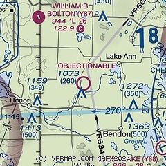
| Sectional chart |
|---|
|
| Airport distance calculator |
|---|
|
|
| Sunrise and sunset |
|---|
|
Times for 19-Nov-2025
| | Local
(UTC-5) | | Zulu
(UTC) |
|---|
| Morning civil twilight | | 07:15 | | 12:15 |
| Sunrise | | 07:47 | | 12:47 |
| Sunset | | 17:11 | | 22:11 |
| Evening civil twilight | | 17:43 | | 22:43 |
|
| Current date and time |
|---|
| Zulu (UTC) | 19-Nov-2025 22:05:54 |
|---|
| Local (UTC-5) | 19-Nov-2025 17:05:54 |
|---|
|
| METAR |
|---|
KFKS
13nm W | 192155Z AUTO 17002KT 10SM CLR 04/M01 A3021 RMK AO2
|
KTVC
15nm E | 192153Z 23004KT 10SM FEW035 OVC250 05/M03 A3021 RMK AO2 SLP237 T00501028
|
|
| TAF |
|---|
KTVC
15nm E | 191727Z 1918/2018 18004KT P6SM SCT035 BKN250 FM201200 18005KT P6SM BKN030 FM201700 20008G16KT P6SM VCSH BKN022
|
|
| NOTAMs |
|---|
NOTAMs are issued by the DoD/FAA and will open in a separate window not controlled by AirNav.
|
|

