FAA INFORMATION EFFECTIVE 27 NOVEMBER 2025
Location
| FAA Identifier: | 57C |
| Lat/Long: | 42-47-49.8000N 088-22-21.4000W
42-47.830000N 088-22.356667W
42.7971667,-88.3726111
(estimated) |
| Elevation: | 860.2 ft. / 262.2 m (surveyed) |
| Variation: | 02W (1995) |
| From city: | 2 miles NE of EAST TROY, WI |
| Time zone: | UTC -6 (UTC -5 during Daylight Saving Time) |
| Zip code: | 53120 |
Airport Operations
| Airport use: | Open to the public |
| Activation date: | 06/1958 |
| Control tower: | no |
| ARTCC: | CHICAGO CENTER |
| FSS: | GREEN BAY FLIGHT SERVICE STATION |
| NOTAMs facility: | GRB (NOTAM-D service available) |
| Attendance: | MON-FRI IREG
FOR SVC AFTER HRS CTC AMGR. |
| Wind indicator: | yes |
| Segmented circle: | no |
| Lights: | MIRL RWY 08/26 PRESET LOW SS-SR; TO INCR INTST AND ACTVT REIL RWY 08 & 26; PAPI RWY 08 & 26; MIRL 08/26 - CTAF. |
| Beacon: | white-green (lighted land airport)
Operates sunset to sunrise. |
Airport Communications
| CTAF/UNICOM: | 123.0 |
| WX AWOS-3PT: | 118.125 (262-642-1845) |
| MILWAUKEE APPROACH: | 125.35 [0800-1600 MON-FRI; EXCP HOLS] |
| MILWAUKEE DEPARTURE: | 125.35 [0800-1600 MON-FRI; EXCP HOLS] |
| GOPAC STAR: | 126.5 |
| WX AWOS-3 at BUU (7 nm SE): | 125.275 (262-757-0907) |
| WX AWOS-3 at UES (16 nm N): | 118.875 (262-521-5226) |
Nearby radio navigation aids
| VOR radial/distance | | VOR name | | Freq | | Var |
|---|
| BAEr189/19.6 | | BADGER VOR/DME | | 116.40 | | 02E |
| JVLr063/35.4 | | JANESVILLE VOR/DME | | 114.30 | | 03E |
| BJBr197/(39.0) | | WEST BEND VOR | | 109.80 | | 01W |
| OBKr334/39.2 | | NORTHBROOK VOR/DME | | 113.00 | | 02W |
| NDB name | | Hdg/Dist | | Freq | | Var | | ID |
|---|
| ROCK RIVER | | 147/27.4 | | 371 | | 01W | | RYV | .-. -.-- ...- |
Airport Services
| Fuel available: | 100LL JET-A+ |
| Parking: | tiedowns |
| Airframe service: | MAJOR |
| Powerplant service: | MAJOR |
| Bottled oxygen: | NONE |
| Bulk oxygen: | NONE |
Runway Information
Runway 8/26
| Dimensions: | 3900 x 75 ft. / 1189 x 23 m
SLOPES UP APRXLY 20 FT FM WEST TO EAST. |
| Surface: | asphalt, in good condition |
| Weight bearing capacity: | |
| Runway edge lights: | medium intensity |
| RUNWAY 8 | | RUNWAY 26 |
| Latitude: | 42-47.788602N | | 42-47.909770N |
| Longitude: | 088-22.769555W | | 088-21.913417W |
| Elevation: | 842.7 ft. | | 860.2 ft. |
| Traffic pattern: | left | | left |
| Runway heading: | 081 magnetic, 079 true | | 261 magnetic, 259 true |
| Markings: | nonprecision, in fair condition | | nonprecision, in fair condition |
| Visual slope indicator: | 2-light PAPI on left (3.00 degrees glide path) | | 2-light PAPI on left (3.00 degrees glide path) |
| Runway end identifier lights: | yes | | yes |
| Touchdown point: | yes, no lights | | yes, no lights |
| Obstructions: | 50 ft. trees, 985 ft. from runway, 325 ft. right of centerline, 15:1 slope to clear | | 57 ft. trees, 1000 ft. from runway, 345 ft. right of centerline, 14:1 slope to clear |
Runway 18/36
| Dimensions: | 2446 x 75 ft. / 746 x 23 m |
| Surface: | turf, in good condition |
| Runway edge markings: | MKD WITH YELLOW CONES. |
| Operational restrictions: | NOT PLOWED, CFM CONDS WITH AMGR. |
| RUNWAY 18 | | RUNWAY 36 |
| Latitude: | 42-47.999327N | | 42-47.597087N |
| Longitude: | 088-22.368865W | | 088-22.395962W |
| Elevation: | 838.5 ft. | | 828.2 ft. |
| Traffic pattern: | left | | left |
| Runway heading: | 185 magnetic, 183 true | | 005 magnetic, 003 true |
| Touchdown point: | yes, no lights | | yes, no lights |
Airport Ownership and Management from official FAA records
| Ownership: | Publicly-owned |
| Owner: | VILLAGE OF EAST TROY
2015 ENERGY DRIVE
EAST TROY, WI 53120
Phone 262-642-6255 |
| Manager: | DOUG GAUGER
2015 ENERGY DR
EAST TROY, WI 53120
Phone 262-642-5008 |
Additional Remarks
| - | ULTRALIGHT & LSA ACTVTY ON & INVOF ARPT. |
| - | NOISE ABATEMENT PROCS IN EFCT. TFC DEPARTING RWY 26 AVOID OVERFLIGHT OF RESIDENTIAL AREA WEST OF FREEWAY. |
| - | FOR CD CTC MILWAUKEE APCH ON GCO. FOR CD WHEN GCO UNA CTC CHICAGO ARTCC AT 630-856-4562. |
| - | GCO AVBL ON FREQ 121.725. |
Instrument Procedures
NOTE: All procedures below are presented as PDF files. If you need a reader for these files, you should download the free Adobe Reader.NOT FOR NAVIGATION. Please procure official charts for flight.
FAA instrument procedures published for use from 27 November 2025 at 0901Z to 25 December 2025 at 0900Z.
STARs - Standard Terminal Arrivals |
|---|
| GOPAC THREE (RNAV) | |
download (232KB) |
IAPs - Instrument Approach Procedures |
|---|
| RNAV (GPS) RWY 08 | |
download (231KB) |
| RNAV (GPS) RWY 26 | |
download (254KB) |
| VOR/DME-A | |
download (164KB) |
Departure Procedures |
|---|
| ACCRA FIVE (RNAV) | |
download (163KB) |
| UECKR SIX (RNAV) | |
download (179KB) |
| NOTE: Special Take-Off Minimums/Departure Procedures apply | |
download (201KB) |
Other nearby airports with instrument procedures:
KBUU - Burlington Municipal Airport (7 nm SE)
C02 - Grand Geneva Resort Airport (11 nm S)
KUES - Waukesha County Airport (16 nm N)
61C - Fort Atkinson Municipal Airport (22 nm NW)
KMKE - General Mitchell International Airport (23 nm NE)
|
|

Road maps at:
MapQuest
Bing
Google
| Aerial photo |
|---|
WARNING: Photo may not be current or correct
 Photo by Jeff Koon
Photo taken 22-Aug-2010
looking Southwest.
Photo by Jeff Koon
Photo taken 22-Aug-2010
looking Southwest.
Do you have a better or more recent aerial photo of East Troy Municipal Airport that you would like to share? If so, please send us your photo.
|
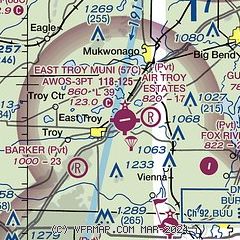
| Sectional chart |
|---|
|
| Airport distance calculator |
|---|
|
|
| Sunrise and sunset |
|---|
|
Times for 05-Dec-2025
| | Local
(UTC-6) | | Zulu
(UTC) |
|---|
| Morning civil twilight | | 06:38 | | 12:38 |
| Sunrise | | 07:10 | | 13:10 |
| Sunset | | 16:19 | | 22:19 |
| Evening civil twilight | | 16:51 | | 22:51 |
|
| Current date and time |
|---|
| Zulu (UTC) | 05-Dec-2025 06:05:09 |
|---|
| Local (UTC-6) | 05-Dec-2025 00:05:09 |
|---|
|
| METAR |
|---|
| K57C | 050555Z AUTO 23004KT 10SM CLR M14/M21 A3010 RMK AO2 T11381210 11136 21205 410951205
|
KBUU
8nm SE | 050555Z AUTO 19008KT 10SM CLR A3011 RMK AO2 PWINO
|
KUES
17nm NE | 050555Z AUTO 20008KT 10SM SCT046 M13/M22 A3010 RMK AO2
|
|
| TAF |
|---|
KUES
17nm NE | 050520Z 0506/0606 21006KT P6SM SCT040 BKN200 TEMPO 0507/0510 SCT024 BKN030 FM051300 22010G19KT P6SM BKN080 FM060000 23007KT P6SM BKN011 OVC024 PROB30 0601/0606 6SM -SNRA OVC015
|
|
| NOTAMs |
|---|
NOTAMs are issued by the DoD/FAA and will open in a separate window not controlled by AirNav.
|
|


