FAA INFORMATION EFFECTIVE 22 JANUARY 2026
Location
| FAA Identifier: | 6R5 |
| Lat/Long: | 29-24-53.1000N 095-17-20.1000W
29-24.885000N 095-17.335000W
29.4147500,-95.2889167
(estimated) |
| Elevation: | 43 ft. / 13 m (estimated) |
| Variation: | 06E (1985) |
| From city: | 3 miles W of ALVIN, TX |
| Time zone: | UTC -6 (UTC -5 during Daylight Saving Time) |
| Zip code: | 77511 |
Airport Operations
| Airport use: | Open to the public |
| Activation date: | 09/1959 |
| Control tower: | no |
| ARTCC: | HOUSTON CENTER |
| FSS: | MONTGOMERY COUNTY FLIGHT SERVICE STATION |
| NOTAMs facility: | CXO (NOTAM-D service available) |
| Attendance: | UNATNDD |
| Wind indicator: | yes |
| Segmented circle: | no |
Airport Communications
| CTAF: | 122.9 |
| WX ASOS at LVJ (7 nm N): | 118.525 (281-992-1853) |
| WX AWOS-3 at AXH (11 nm NW): | 123.625 (281-431-6572) |
| WX AWOS-3 at EFD (13 nm NE): | 135.575 (713-847-4430) |
| WX ASOS at HOU (14 nm N): | PHONE 713-847-1462 |
| WX AWOS-3PT at T41 (19 nm NE): | 120.275 (281-471-2206) |
Nearby radio navigation aids
| VOR radial/distance | | VOR name | | Freq | | Var |
|---|
| VUHr286/23.7 | | SCHOLES VOR/DME | | 113.00 | | 06E |
| MHFr247/29.4 | | TRINITY VOR/DME | | 114.75 | | 07E |
| IAHr170/32.7 | | HUMBLE VORTAC | | 116.60 | | 05E |
Airport Services
| Parking: | hangars and tiedowns |
Runway Information
Runway 6/24
| Dimensions: | 1500 x 80 ft. / 457 x 24 m |
| Surface: | turf, in poor condition
RWY DEFINED BY MOWING. DFCLT TO DTRM RWY DIMENSIONS. RWY SFC ROUGH & UNEVEN. |
| RUNWAY 6 | | RUNWAY 24 |
| Latitude: | 29-24.873632N | | 29-24.952375N |
| Longitude: | 095-17.473242W | | 095-17.205188W |
| Elevation: | 41.0 ft. | | 42.0 ft. |
| Traffic pattern: | left | | left |
| Runway heading: | 065 magnetic, 071 true | | 245 magnetic, 251 true |
| Obstructions: | 34 ft. pline, 55 ft. left of centerline
CTLG OBSTN EXCEEDS 45 DEG SLP. | | 50 ft. trees |
Runway 3/21
| Dimensions: | 1420 x 75 ft. / 433 x 23 m |
| Surface: | turf, in poor condition
RWY DEFINED BY MOWING. DFCLT TO DTRM RWY DIMENSIONS. RWY SFC ROUGH & UNEVEN. |
| RUNWAY 3 | | RUNWAY 21 |
| Latitude: | 29-24.794085N | | 29-24.972068N |
| Longitude: | 095-17.366012W | | 095-17.191893W |
| Elevation: | 41.0 ft. | | 41.0 ft. |
| Traffic pattern: | left | | left |
| Runway heading: | 035 magnetic, 041 true | | 215 magnetic, 221 true |
| Obstructions: | 40 ft. trees, 35 ft. right of centerline
CTLG OBSTN EXCEEDS 45 DEG SLP. | | 40 ft. trees, 50 ft. left of centerline |
Runway 12/30
| Dimensions: | 830 x 60 ft. / 253 x 18 m |
| Surface: | turf, in poor condition
RWY DEFINED BY MOWING. DFCLT TO DTRM RWY DIMENSIONS. RWY SFC ROUGH & UNEVEN. |
| RUNWAY 12 | | RUNWAY 30 |
| Latitude: | 29-24.884553N | | 29-24.794608N |
| Longitude: | 095-17.478783W | | 095-17.360790W |
| Elevation: | 42.0 ft. | | 41.0 ft. |
| Traffic pattern: | left | | left |
| Runway heading: | 125 magnetic, 131 true | | 305 magnetic, 311 true |
| Obstructions: | 34 ft. pline
CTLG OBSTN EXCEEDS 45 DEG SLP. | | 50 ft. trees, 60 ft. right of centerline |
Airport Ownership and Management from official FAA records
| Ownership: | Privately-owned |
| Owner: | RSNMART PROPERTIES, LLC
2102 CHERRY HILL DR
LEAGUE CITY, TX 77573
Phone 713-208-8707 |
| Manager: | RANDY SMART
12357 CR 280
ALVIN, TX 77511
Phone 713-208-8707 |
Additional Remarks
| - | RWY 03, 6 FT FENCE 40 FT SE OF CNTRLN ALG SE EDGE. +50 FT TREES ALG RWY 03 RIGHT OF CNTRLN. |
| - | RWY 21, 6 FT FENCE 20 FT FM THR 0B. 30 FT TREES ALG RWY 21 LEFT OF CNTRLN. |
| - | RADIO CONTROL MODEL ACFT OPRG AREA ADJ TO ARPT, NW. |
| - | 6 FT ARPT SCTY FENCE. ALL GATES LOCKED. FOR INGRESS OR EGRESS, CTC AMGR. |
| - | FOR CD CTC HOUSTON APCH AT 281-443-5844 TO CNL IFR CALL 281-443-5888. |
Instrument Procedures
There are no published instrument procedures at 6R5.
Some nearby airports with instrument procedures:
KLVJ - Pearland Regional Airport (7 nm N)
KAXH - Houston Southwest Airport (11 nm NW)
KEFD - Ellington Airport (13 nm NE)
KHOU - William P Hobby Airport (14 nm N)
T41 - La Porte Municipal Airport (19 nm NE)
|
|

Road maps at:
MapQuest
Bing
Google
| Aerial photo |
|---|
WARNING: Photo may not be current or correct

Do you have a better or more recent aerial photo of Alvin Airpark that you would like to share? If so, please send us your photo.
|
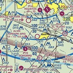
| Sectional chart |
|---|
|
| Airport distance calculator |
|---|
|
|
| Sunrise and sunset |
|---|
|
Times for 23-Jan-2026
| | Local
(UTC-6) | | Zulu
(UTC) |
|---|
| Morning civil twilight | | 06:50 | | 12:50 |
| Sunrise | | 07:16 | | 13:16 |
| Sunset | | 17:50 | | 23:50 |
| Evening civil twilight | | 18:16 | | 00:16 |
|
| Current date and time |
|---|
| Zulu (UTC) | 23-Jan-2026 12:28:04 |
|---|
| Local (UTC-6) | 23-Jan-2026 06:28:04 |
|---|
|
| METAR |
|---|
KLVJ
6nm N | 231153Z AUTO 09005KT 1SM BR OVC002 16/16 A3010 RMK AO2 SLP191 60000 T01560156 10161 20156 53010
|
KAXH
11nm NW | 231215Z AUTO 09004KT 1 3/4SM -RA OVC003 A3010 RMK AO2
|
KEFD
13nm NE | 231154Z 09008KT 1/4SM FG OVC003 16/16 A3007
|
KHOU
13nm N | 231153Z 11006KT 6SM -RA BR OVC004 16/16 A3008 RMK AO2 RAE12B53 SLP191 P0001 60001 70001 T01610156 10161 20156 53010
|
KT41
19nm NE | 231215Z AUTO 09006KT 1 1/4SM BR OVC003 16/16 A3010 RMK AO2 P0001 T01580156
|
|
| TAF |
|---|
KEFD
13nm NE | 231200Z 2312/2418 09008KT 0800 FG OVC005 QNH3007INS BECMG 2315/2316 08010G15KT 4800 BR OVC010 QNH2995INS BECMG 2404/2405 08010G15KT 1600 BR OVC005 QNH2998INS BECMG 2414/2415 06010G20KT 8000 -SHRA OVC005 QNH2991INS TX17/2320Z TN15/2409Z
|
KHOU
13nm N | 231133Z 2312/2412 09006KT 3SM -DZ BR OVC002 TEMPO 2312/2314 VRB04KT 3/4SM BR VV002 FM231600 09007KT 5SM BR OVC005 FM232100 09010KT P6SM BKN007 OVC012 FM240300 09013KT P6SM OVC007
|
|
| NOTAMs |
|---|
NOTAMs are issued by the DoD/FAA and will open in a separate window not controlled by AirNav.
|
|

