FAA INFORMATION EFFECTIVE 30 OCTOBER 2025
Location
| FAA Identifier: | AXH |
| Lat/Long: | 29-30-22.1000N 095-28-36.9000W
29-30.368333N 095-28.615000W
29.5061389,-95.4769167
(estimated) |
| Elevation: | 68.9 ft. / 21.0 m (surveyed) |
| Variation: | 05E (2000) |
| From city: | 15 miles SW of HOUSTON, TX |
| Time zone: | UTC -6 (UTC -5 during Daylight Saving Time) |
| Zip code: | 77583 |
Airport Operations
| Airport use: | Open to the public |
| Activation date: | 02/1979 |
| Control tower: | no |
| ARTCC: | HOUSTON CENTER |
| FSS: | MONTGOMERY COUNTY FLIGHT SERVICE STATION |
| NOTAMs facility: | CXO (NOTAM-D service available) |
| Attendance: | CONTINUOUS |
| Wind indicator: | lighted |
| Segmented circle: | no |
| Lights: | MIRL RWY 09/27 PRESET LOW INTST DUSK-DAWN, TO INCR INTST & ACTVT REIL RWY 09 & 27- CTAF. |
| Beacon: | white-green (lighted land airport)
Operates sunset to sunrise. |
Airport Communications
| CTAF/UNICOM: | 123.0 |
| WX AWOS-3: | 123.625 (281-431-6572) |
| HOUSTON APPROACH: | 123.8 |
| HOUSTON DEPARTURE: | 123.8 |
| CLEARANCE DELIVERY: | 120.8 |
| ALEXANDRIA DP: | 123.8 |
| BLTWY RNAV DP: | 123.8 |
| BLUBELL STAR: | 124.225 |
| BORRN RNAV DP: | 123.8 |
| CESAN STAR: | 121.3 |
| CRIED DP: | 123.8 |
| DREMR DP: | 123.8 |
| EL DORADO DP: | 123.8 |
| GIFFA DP: | 123.8 |
| HOODO RNAV DP: | 123.8 |
| HUDZY STAR: | 120.05 |
| INDIE RNAV DP: | 123.8 |
| KARRR RNAV DP: | 123.8 |
| LEONA DP: | 123.8 |
| LUFKIN DP: | 123.8 |
| LURIC DP: | 123.8 |
| MMALT RNAV DP: | 123.8 |
| OHIIO STAR: | 120.05 |
| SNDAY RNAV STAR: | 124.225 |
| STRYA DP: | 123.8 |
| STYCK DP: | 123.8 |
| TKNIQ STAR: | 119.625 |
| TSHIRT STAR: | 119.175 |
| TSHRT STAR: | 119.175 |
| WAPPL STAR: | 120.05 |
| WATFO DP: | 123.8 |
| WYLSN RNAV DP: | 123.8 |
| WX ASOS at SGR (12 nm NW): | 118.125 (281-242-7605) |
| WX ASOS at LVJ (12 nm E): | 118.525 (281-992-1853) |
| WX ASOS at HOU (13 nm NE): | PHONE 713-847-1462 |
| WX AWOS-3 at EFD (18 nm E): | 135.575 (713-847-4430) |
Nearby radio navigation aids
| VOR radial/distance | | VOR name | | Freq | | Var |
|---|
| IAHr189/27.9 | | HUMBLE VORTAC | | 116.60 | | 05E |
| VUHr288/34.9 | | SCHOLES VOR/DME | | 113.00 | | 06E |
| MHFr259/38.2 | | TRINITY VOR/DME | | 114.75 | | 07E |
Airport Services
| Fuel available: | 100LL JET-A+ |
| Parking: | hangars and tiedowns |
| Airframe service: | MAJOR |
| Powerplant service: | MAJOR |
| Bottled oxygen: | HIGH |
Runway Information
Runway 9/27
| Dimensions: | 5002 x 100 ft. / 1525 x 30 m |
| Surface: | asphalt, in excellent condition |
| Weight bearing capacity: | | Single wheel: | 60.0 | | Double wheel: | 75.0 | | Double tandem: | 100.0 |
|
| Runway edge lights: | medium intensity |
| RUNWAY 9 | | RUNWAY 27 |
| Latitude: | 29-30.398505N | | 29-30.337558N |
| Longitude: | 095-29.085042W | | 095-28.144123W |
| Elevation: | 68.9 ft. | | 66.4 ft. |
| Traffic pattern: | left | | left |
| Runway heading: | 089 magnetic, 094 true | | 269 magnetic, 274 true |
| Markings: | nonprecision, in good condition | | nonprecision, in good condition |
| Visual slope indicator: | 2-light PAPI on left (3.50 degrees glide path) | | 2-light PAPI on left (3.00 degrees glide path) |
| Runway end identifier lights: | yes | | yes |
| Touchdown point: | yes, no lights | | yes, no lights |
| Instrument approach: | LOC/DME | | |
| Obstructions: | 15 ft. road, 265 ft. from runway, 260 ft. left of centerline, 4:1 slope to clear | | 15 ft. road, 330 ft. from runway, 8:1 slope to clear |
Airport Ownership and Management from official FAA records
| Ownership: | Privately-owned |
| Owner: | JAMES GRIFFITH JR
503 MC KEEVER RD
ARCOLA, TX 77583
Phone 281-431-2581 |
| Manager: | LEN FRANKLIN
503 MC KEEVER RD #1505
ARCOLA, TX 77583
Phone 281-431-2581 |
Additional Remarks
| - | HEL TFC INVOF ARPT. RWY 09 CALM WIND RWY. |
| - | FOR CD CTC HOUSTON APCH AT 281-443-5844. TO CNL IFR CTC HOUSTON APCH AT 281-443-5888. |
Instrument Procedures
NOTE: All procedures below are presented as PDF files. If you need a reader for these files, you should download the free Adobe Reader.NOT FOR NAVIGATION. Please procure official charts for flight.
FAA instrument procedures published for use from 30 October 2025 at 0901Z to 27 November 2025 at 0900Z.
STARs - Standard Terminal Arrivals |
|---|
| CESAN FOUR (RNAV) | |
2 pages:
[1] [2] (403KB) |
| HUDZY FIVE | |
2 pages:
[1] [2] (281KB) |
| OHIIO FOUR | |
download (265KB) |
| SNDAY ONE (RNAV) | |
download (232KB) |
| TKNIQ THREE (RNAV) | |
2 pages:
[1] [2] (328KB) |
| TSHRT TWO | |
2 pages:
[1] [2] (339KB) |
| WAPPL SEVEN (RNAV) | |
2 pages:
[1] [2] (404KB) |
| WAPPL SEVEN (RNAV), CONT.2 | |
download (283KB) |
IAPs - Instrument Approach Procedures |
|---|
| RNAV (GPS) RWY 09 | |
download (186KB) |
| RNAV (GPS) RWY 27 | |
download (199KB) |
| LOC RWY 09 | |
download (168KB) |
Departure Procedures |
|---|
| ALEXANDRIA THREE | |
2 pages:
[1] [2] (348KB) |
| BLTWY SEVEN (RNAV) | |
download (154KB) |
| BORRN SIX (RNAV) | |
2 pages:
[1] [2] (300KB) |
| CRIED ONE | |
download (192KB) |
| EL DORADO ONE | |
2 pages:
[1] [2] (264KB) |
| GIFFA ONE | |
2 pages:
[1] [2] (249KB) |
| HOODO SEVEN (RNAV) | |
download (196KB) |
| INDIE EIGHT (RNAV) | |
download (183KB) |
| KARRR SEVEN (RNAV) | |
2 pages:
[1] [2] (247KB) |
| LEONA FOUR | |
2 pages:
[1] [2] (364KB) |
| LUFKIN THREE | |
2 pages:
[1] [2] (267KB) |
| LURIC EIGHT (RNAV) | |
download (204KB) |
| MMALT SEVEN (RNAV) | |
download (210KB) |
| STRYA EIGHT (RNAV) | |
download (193KB) |
| STYCK EIGHT (RNAV) | |
download (179KB) |
| WATFO SIX (RNAV) | |
download (163KB) |
| WYLSN EIGHT (RNAV) | |
download (167KB) |
| NOTE: Special Take-Off Minimums/Departure Procedures apply | |
download (207KB) |
Other nearby airports with instrument procedures:
KSGR - Sugar Land Regional Airport (12 nm NW)
KLVJ - Pearland Regional Airport (12 nm E)
KHOU - William P Hobby Airport (13 nm NE)
KEFD - Ellington Airport (18 nm E)
KIWS - West Houston Airport (21 nm NW)
|
|

Road maps at:
MapQuest
Bing
Google
| Aerial photo |
|---|
WARNING: Photo may not be current or correct
 Photo by John Dyer
Taken in April 2020
looking east.
Photo by John Dyer
Taken in April 2020
looking east.
Do you have a better or more recent aerial photo of Houston Southwest Airport that you would like to share? If so, please send us your photo.
|
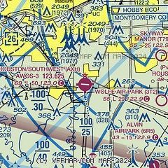
| Sectional chart |
|---|
|
CAUTION: Diagram may not be current

| Airport distance calculator |
|---|
|
|
| Sunrise and sunset |
|---|
|
Times for 07-Nov-2025
| | Local
(UTC-6) | | Zulu
(UTC) |
|---|
| Morning civil twilight | | 06:16 | | 12:16 |
| Sunrise | | 06:41 | | 12:41 |
| Sunset | | 17:30 | | 23:30 |
| Evening civil twilight | | 17:55 | | 23:55 |
|
| Current date and time |
|---|
| Zulu (UTC) | 08-Nov-2025 04:50:19 |
|---|
| Local (UTC-6) | 07-Nov-2025 22:50:19 |
|---|
|
| METAR |
|---|
| KAXH | 080435Z AUTO 00000KT 10SM 19/19 A2982 RMK AO2 T01920185
|
KSGR
11nm NW | 080353Z AUTO 18005KT 10SM CLR 21/19 A2980 RMK AO2 SLP091 T02060189
|
KLVJ
12nm E | 080353Z AUTO 00000KT 10SM CLR 21/19 A2982 RMK AO2 SLP096 T02060189
|
KHOU
13nm NE | 080353Z 18005KT 10SM CLR 21/19 A2980 RMK AO2 SLP094 T02110194
|
KEFD
17nm E | 080254Z 18006KT 10SM CLR 21/19 A2979
|
|
| TAF |
|---|
KSGR
11nm NW | 071720Z 0718/0818 23010G17KT P6SM SKC FM080300 VRB04KT P6SM FEW250 FM080600 VRB03KT 4SM BR FEW003 FM081500 23006KT P6SM SCT015 SCT250
|
KHOU
13nm NE | 080302Z 0803/0824 19006KT P6SM SKC FM080800 24003KT 5SM BR FEW007 FM081400 24006KT P6SM FEW010 FM081800 24008KT P6SM SKC
|
KEFD
17nm E | 080400Z 0804/0910 VRB06KT 9999 FEW015 QNH2980INS BECMG 0807/0808 VRB03KT 9999 BKN010 OVC020 QNH2981INS BECMG 0817/0818 VRB06KT 9999 SCT010 BKN025 QNH2987INS TX27/0821Z TN19/0810Z
|
|
| NOTAMs |
|---|
NOTAMs are issued by the DoD/FAA and will open in a separate window not controlled by AirNav.
|
|


