FAA INFORMATION EFFECTIVE 16 APRIL 2026
Location
| FAA Identifier: | 6Y0 |
| Lat/Long: | 44-27-46.7396N 084-59-47.7531W
44-27.778993N 084-59.795885W
44.4629832,-84.9965981
(estimated) |
| Elevation: | 1211 ft. / 369 m (estimated) |
| Variation: | 05W (1985) |
| From city: | 1 mile SE of MOORESTOWN, MI |
| Time zone: | UTC -4 (UTC -5 during Standard Time) |
| Zip code: | 49651 |
Airport Operations
| Airport use: | Open to the public |
| Activation date: | 08/1970 |
| Control tower: | no |
| ARTCC: | MINNEAPOLIS CENTER |
| FSS: | LANSING FLIGHT SERVICE STATION |
| NOTAMs facility: | LAN (NOTAM-D service available) |
| Attendance: | APR-NOV DAWN-DUSK |
| Wind indicator: | yes |
| Segmented circle: | yes |
Airport Communications
| CTAF: | 122.9 |
| WX ASOS at HTL (15 nm SE): | 118.05 (989-200-3352) |
| WX ASOS at GOV (17 nm NE): | PHONE 989-348-3127 |
Nearby radio navigation aids
| VOR radial/distance | | VOR name | | Freq | | Var |
|---|
| CGGr227/(17.4) | | GRAYLING VOR | | 109.80 | | 06W |
| TVCr119/26.7 | | TRAVERSE CITY VOR/DME | | 114.60 | | 02W |
| GLRr207/35.2 | | GAYLORD VOR/DME | | 109.20 | | 06W |
| NDB name | | Hdg/Dist | | Freq | | Var | | ID |
|---|
| GRAYLING | | 209/18.7 | | 359 | | 06W | | GYG | --. -.-- --. |
Airport Services
| Parking: | tiedowns |
| Airframe service: | NONE |
| Powerplant service: | NONE |
| Bottled oxygen: | NONE |
| Bulk oxygen: | NONE |
Runway Information
Runway 3/21
| Dimensions: | 2800 x 100 ft. / 853 x 30 m |
| Surface: | turf, in fair condition |
| Runway edge markings: | RWY & DTHR MKD WITH 3 FT YELLOW CONES. |
| RUNWAY 3 | | RUNWAY 21 |
| Latitude: | 44-27.516500N | | 44-27.932833N |
| Longitude: | 084-59.861167W | | 084-59.586000W |
| Elevation: | 1201.0 ft. | | 1203.0 ft. |
| Traffic pattern: | left | | left |
| Runway heading: | 030 magnetic, 025 true | | 210 magnetic, 205 true |
| Displaced threshold: | 801 ft. | | 1191 ft. |
| Runway end identifier lights: | no | | no |
| Obstructions: | 15 ft. trees, 25 ft. from runway, 125 ft. left of centerline, 1:1 slope to clear
ALSO 60 FT TREES, 180 FT DIST. | | 15 ft. road, 80 ft. left of centerline
APCH RATIO 17:1 AT DTHR BASED ON STRAIGHT OUT OVR 70 FT TREES, 1210 FT DIST. |
Runway 9/27
| Dimensions: | 2600 x 100 ft. / 792 x 30 m |
| Surface: | turf, in fair condition |
| Runway edge markings: | RWY & DTHR MKD WITH 3 FT YELLOW CONES. |
| RUNWAY 9 | | RUNWAY 27 |
| Latitude: | 44-27.841667N | | 44-27.833333N |
| Longitude: | 085-00.172500W | | 084-59.575000W |
| Elevation: | 1205.0 ft. | | 1210.0 ft. |
| Traffic pattern: | left | | left |
| Runway heading: | 096 magnetic, 091 true | | 276 magnetic, 271 true |
| Displaced threshold: | 800 ft. | | 421 ft. |
| Runway end identifier lights: | no | | no |
| Obstructions: | 26 ft. trees, 110 ft. right of centerline
APCH RATIO 0:1 AT DTHR OVR 40 FT TREES, 0 FT DIST, 90 FT R; 18:1 BASED ON STRAIGHT OUT OVR 96 FT TREES, 1810 FT DIST. | | 15 ft. road, 34 ft. from runway, 128 ft. left and right of centerline, 2:1 slope to clear |
Airport Ownership and Management from official FAA records
| Ownership: | Privately-owned |
| Owner: | LOIS WHIPPLE
4840 E MOORESTOWN RD
LAKE CITY, MI 49651-9739
Phone 231-229-4232 |
| Manager: | LOIS WHIPPLE
4840 E MOORESTOWN RD
LAKE CITY, MI 49651-9739
Phone 231-229-4232
EVE 231-224-4443. |
Additional Remarks
| - | NO SNOW REMOVAL, WINTER OPS FOR SKI-EQUIPPED ACFT ONLY. |
| - | FOR CD CTC MINNEAPOLIS ARTCC AT 651-463-5588. |
| - | LRG BIRDS ON & INVOF ARPT. |
| - | RWY 21: UNMKD PLINES ON APCH. |
Instrument Procedures
There are no published instrument procedures at 6Y0.
Some nearby airports with instrument procedures:
KHTL - Roscommon County/Blodgett Memorial Airport (15 nm SE)
KGOV - Grayling Army Airfield (17 nm NE)
KCAD - Wexford County Airport (21 nm SW)
KTVC - Cherry Capital Airport (30 nm NW)
KACB - Antrim County Airport (33 nm N)
|
|

Road maps at:
MapQuest
Bing
Google
| Aerial photo |
|---|

|
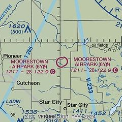
| Sectional chart |
|---|
|
| Airport distance calculator |
|---|
|
|
| Sunrise and sunset |
|---|
|
Times for 19-Apr-2026
| | Local
(UTC-4) | | Zulu
(UTC) |
|---|
| Morning civil twilight | | 06:20 | | 10:20 |
| Sunrise | | 06:50 | | 10:50 |
| Sunset | | 20:28 | | 00:28 |
| Evening civil twilight | | 20:59 | | 00:59 |
|
| Current date and time |
|---|
| Zulu (UTC) | 19-Apr-2026 05:50:11 |
|---|
| Local (UTC-4) | 19-Apr-2026 01:50:11 |
|---|
|
| METAR |
|---|
KHTL
16nm SE | 190453Z AUTO 27015G24KT 10SM OVC070 03/M05 A2991 RMK AO2 PK WND 28027/0401 SLP140 T00281050 401670028
|
KGOV
17nm NE | 190455Z AUTO 28006KT 10SM OVC065 02/M05 A2988 RMK AO2 SLP135 T00241048 $
|
KCAD
22nm SW | 190535Z AUTO 27006KT 10SM OVC060 01/M06 A2992 RMK AO2
|
KTVC
29nm NW | 190453Z AUTO 26013KT 10SM OVC075 04/M06 A2991 RMK AO2 SLP135 T00391061 401720033
|
|
| NOTAMs |
|---|
NOTAMs are issued by the DoD/FAA and will open in a separate window not controlled by AirNav.
|
|

