FAA INFORMATION EFFECTIVE 30 OCTOBER 2025
Location
| FAA Identifier: | 6Y6 |
| Lat/Long: | 44-22-04.8125N 084-24-07.7600W
44-22.080208N 084-24.129333W
44.3680035,-84.4021556
(estimated) |
| Elevation: | 1198 ft. / 365 m (estimated) |
| Variation: | 05W (1985) |
| From city: | 1 mile SE of ST HELEN, MI |
| Time zone: | UTC -5 (UTC -4 during Daylight Saving Time) |
| Zip code: | 48656 |
Airport Operations
| Airport use: | Open to the public |
| Activation date: | 04/1940 |
| Control tower: | no |
| ARTCC: | MINNEAPOLIS CENTER |
| FSS: | LANSING FLIGHT SERVICE STATION |
| NOTAMs facility: | LAN (NOTAM-D service available) |
| Attendance: | UNATNDD |
| Wind indicator: | yes |
| Segmented circle: | yes |
Airport Communications
| CTAF: | 122.9 |
| WX ASOS at HTL (11 nm W): | 118.05 (989-200-3352) |
| WX AWOS-3P at Y31 (12 nm SE): | 119.575 (989-787-1100) |
Nearby radio navigation aids
| VOR radial/distance | | VOR name | | Freq | | Var |
|---|
| CGGr149/(23.4) | | GRAYLING VOR | | 109.80 | | 06W |
| NDB name | | Hdg/Dist | | Freq | | Var | | ID |
|---|
| GRAYLING | | 148/29.3 | | 359 | | 06W | | GYG | --. -.-- --. |
Airport Services
| Parking: | tiedowns |
| Airframe service: | NONE |
| Powerplant service: | NONE |
| Bottled oxygen: | NONE |
| Bulk oxygen: | NONE |
Runway Information
Runway 12/30
| Dimensions: | 2600 x 120 ft. / 792 x 37 m |
| Surface: | turf, in good condition |
| Runway edge markings: | RWY & DTHR MKD WITH 3 FT YELLOW CONES. |
| RUNWAY 12 | | RUNWAY 30 |
| Latitude: | 44-22.222000N | | 44-22.038500N |
| Longitude: | 084-24.283333W | | 084-23.744333W |
| Elevation: | 1191.0 ft. | | 1196.0 ft. |
| Traffic pattern: | left | | left |
| Runway heading: | 120 magnetic, 115 true | | 300 magnetic, 295 true |
| Displaced threshold: | 812 ft. | | 988 ft. |
| Runway end identifier lights: | no | | no |
| Obstructions: | 67 ft. trees, 195 ft. from runway, 30 ft. right of centerline, 2:1 slope to clear
APCH RATIO 6:1 TO DTHR OVR +64 FT TREE, 1030 FT DIST, 95 FT R. | | 15 ft. road, 60 ft. left of centerline
APCH RATIO 20:1 TO DTHR. |
Runway 18/36
| Dimensions: | 2600 x 110 ft. / 792 x 34 m |
| Surface: | turf, in good condition |
| Runway edge markings: | RWY & DTHR MKD WITH 3 FT YELLOW CONES. |
| RUNWAY 18 | | RUNWAY 36 |
| Latitude: | 44-22.244167N | | 44-21.816167N |
| Longitude: | 084-24.246500W | | 084-24.243167W |
| Elevation: | 1191.0 ft. | | 1191.0 ft. |
| Traffic pattern: | left | | left |
| Runway heading: | 185 magnetic, 180 true | | 005 magnetic, 360 true |
| Displaced threshold: | 810 ft. | | 400 ft. |
| Runway end identifier lights: | no | | no |
| Obstructions: | 25 ft. trees, 60 ft. from runway, 75 ft. right of centerline, 2:1 slope to clear
APCH RATIO 19:1 TO DTHR OVR +71 FT TREE, 1398 FT DIST, 10 FT R. | | 18 ft. road, 40 ft. from runway, 125 ft. left and right of centerline, 2:1 slope to clear
APCH RATIO 20:1 TO DTHR. |
Airport Ownership and Management from official FAA records
| Ownership: | Publicly-owned |
| Owner: | RICHFIELD TOWNSHIP
1410 N SAINT HELEN RD
SAINT HELEN, MI 48656-7506
Phone 989-389-4994 |
| Manager: | ROBERT COULTER
9376 ROSE DR
SAINT HELEN, MI 48656-9355
Phone 323-974-0409 |
Additional Remarks
| - | ARPT CLSD DEC-MAR & WHEN SNOW COVD. |
| - | HNGRS LCTD 135 FT WEST OF RWY 18/36 CNTRLN. |
| - | FOR CD CTC MINNEAPOLIS ARTCC AT 651-463-5588. |
| - | DEER & LRG BIRDS ON & INVOF ARPT. |
Instrument Procedures
There are no published instrument procedures at 6Y6.
Some nearby airports with instrument procedures:
KHTL - Roscommon County/Blodgett Memorial Airport (11 nm W)
Y31 - West Branch Community Airport (12 nm SE)
KGOV - Grayling Army Airfield (23 nm NW)
KGDW - Gladwin Zettel Memorial Airport (24 nm S)
48D - Clare Municipal Airport (35 nm SW)
|
|

Road maps at:
MapQuest
Bing
Google
| Aerial photo |
|---|
WARNING: Photo may not be current or correct
 Photo taken 22-Sep-2018
looking south.
Photo taken 22-Sep-2018
looking south.
Do you have a better or more recent aerial photo of St Helen Airport that you would like to share? If so, please send us your photo.
|
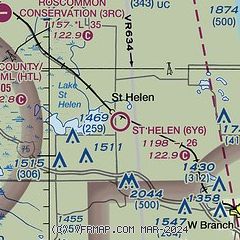
| Sectional chart |
|---|
|
| Airport distance calculator |
|---|
|
|
| Sunrise and sunset |
|---|
|
Times for 15-Nov-2025
| | Local
(UTC-5) | | Zulu
(UTC) |
|---|
| Morning civil twilight | | 07:03 | | 12:03 |
| Sunrise | | 07:35 | | 12:35 |
| Sunset | | 17:10 | | 22:10 |
| Evening civil twilight | | 17:41 | | 22:41 |
|
| Current date and time |
|---|
| Zulu (UTC) | 15-Nov-2025 13:59:34 |
|---|
| Local (UTC-5) | 15-Nov-2025 08:59:34 |
|---|
|
| METAR |
|---|
KHTL
11nm W | 151353Z AUTO 20008KT 5SM BR OVC006 09/08 A2945 RMK AO2 SLP978 T00890078
|
KY31
12nm SE | 151335Z AUTO 00000KT 10SM OVC008 04/04 A2947 RMK AO2 T00390038
|
|
| NOTAMs |
|---|
NOTAMs are issued by the DoD/FAA and will open in a separate window not controlled by AirNav.
|
|

