FAA INFORMATION EFFECTIVE 03 OCTOBER 2024
Location
| FAA Identifier: | 6Y9 |
| Lat/Long: | 46-30-31.1500N 088-42-21.0500W
46-30.519167N 088-42.350833W
46.5086528,-88.7058472
(estimated) |
| Elevation: | 1372 ft. / 418.2 m (surveyed) |
| Variation: | 02W (1985) |
| From city: | 1 mile NE of SIDNAW, MI |
| Time zone: | UTC -4 (UTC -5 during Standard Time) |
| Zip code: | 49970 |
Airport Operations
| Airport use: | Open to the public |
| Activation date: | 04/1940 |
| Control tower: | no |
| ARTCC: | MINNEAPOLIS CENTER |
| FSS: | GREEN BAY FLIGHT SERVICE STATION |
| NOTAMs facility: | GRB (NOTAM-D service available) |
| Attendance: | UNATNDD |
| Wind indicator: | yes |
| Segmented circle: | no |
Airport Communications
Airport Services
| Parking: | tiedowns |
| Airframe service: | NONE |
| Powerplant service: | NONE |
| Bottled oxygen: | NONE |
| Bulk oxygen: | NONE |
Runway Information
Runway 10/28
| Dimensions: | 2600 x 100 ft. / 792 x 30 m |
| Surface: | turf, in good condition
SOFT WHEN WET; CALL 248-761-5615 TO VFY COND. |
| Runway edge markings: | 10/28 MKD WITH 3 FT YELLOW CONES. |
| RUNWAY 10 | | RUNWAY 28 |
| Latitude: | 46-30.553333N | | 46-30.485000N |
| Longitude: | 088-42.656667W | | 088-42.045000W |
| Elevation: | 1362.0 ft. | | 1377.0 ft. |
| Traffic pattern: | left | | left |
| Displaced threshold: | 400 ft. | | 400 ft. |
| Runway end identifier lights: | no | | no |
| Obstructions: | 30 ft. pole, marked, 300 ft. from runway, 51 ft. right of centerline, 10:1 slope to clear
APCH SLP TO DTHR 14:1 OVR 82 FT TREES, 1174 DIST, 30 FT L. | | 23 ft. trees, 113 ft. from runway, 40 ft. right of centerline, 4:1 slope to clear
APCH SLP TO DTHR 11:1 OVR 68 FT TREES, 750 FT DIST, 20 FT R. |
Airport Ownership and Management from official FAA records
| Ownership: | Privately-owned |
| Owner: | SHCAHA
7370 BROADMOOR AVE. S.E.
CALEDONIA, MI 49316
Phone (248) 761-5615
SOUTHERN HOUGHTON COUNTY AIRPORT & HERITAGE ASSOCIATION |
| Manager: | BRAD FREDERICK
7370 BROADMOOR AVE. S.E.
CALEDONIA, MI 49316
Phone (248) 761-5615 |
Additional Remarks
| - | RYS NOT PLOWED. ARPT CLSD NOV-MAY 15 & WHEN SNOW COVERED EXCEPT FOR SKI EQUIPPED ACFT. |
| - | CAMPING & CABINS ADJACENT, PH 906-355-2480. |
| - | PILOT SHELTER ACCESS: 1200 |
| - | DEER, BIRDS, & WILDLIFE ON & INVOF ARPT. |
| - | ARPT IS NEAR MIL.TNG RTS VR 1639 & IR 609 & UNDERLIES BIG BEAR MOA. LOW LEVEL, HIGH SPEED MIL ACFT OPER IN VICINITY. |
| - | FOR CD CTC MINNEAPOLIS ARTCC AT 651-463-5588. |
Instrument Procedures
There are no published instrument procedures at 6Y9.
Some nearby airports with instrument procedures:
KLNL - Kings Land O' Lakes Airport (30 nm SW)
KOGM - Ontonagon County Airport/Schuster Field (34 nm NW)
KCMX - Houghton County Memorial Airport (41 nm N)
KEGV - Eagle River Union Airport (42 nm SW)
KIMT - Ford Airport (48 nm SE)
|
|

Road maps at:
MapQuest
Bing
Google
| Aerial photo |
|---|
WARNING: Photo may not be current or correct
 from the NW
Do you have a better or more recent aerial photo of Prickett-Grooms Field Airport that you would like to share? If so, please send us your photo.
|
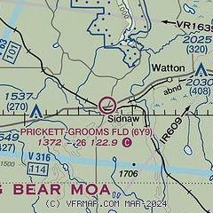
| Sectional chart |
|---|
|
| Airport distance calculator |
|---|
|
|
| Sunrise and sunset |
|---|
|
Times for 06-Oct-2024
| | Local
(UTC-4) | | Zulu
(UTC) |
|---|
| Morning civil twilight | | 07:32 | | 11:32 |
| Sunrise | | 08:02 | | 12:02 |
| Sunset | | 19:23 | | 23:23 |
| Evening civil twilight | | 19:53 | | 23:53 |
|
| Current date and time |
|---|
| Zulu (UTC) | 07-Oct-2024 00:01:09 |
|---|
| Local (UTC-4) | 06-Oct-2024 20:01:09 |
|---|
|
| METAR |
|---|
KLNL
30nm SW | 062335Z AUTO 31011G20KT 10SM OVC034 09/03 A3001 RMK AO2 T00930025
|
KCMX
41nm N | 062353Z AUTO 30021G34KT 10SM SCT027 BKN037 11/04 A2991 RMK AO2 PK WND 29037/2310 SLP134 T01060039 10106 20100 51027
|
KEGV
42nm SW | 062335Z AUTO 29009G21KT 240V320 10SM BKN034 OVC040 09/02 A3001 RMK AO2 T00920018
|
KIMT
48nm SE | 062354Z AUTO 29016G27KT 10SM OVC040 11/03 A2995 RMK AO2 PK WND 31027/2345 SLP148 T01110033 10117 20100 53020
|
|
| TAF |
|---|
KCMX
41nm N | 062158Z 0622/0718 30022G40KT P6SM BKN035 FM070100 31019G36KT P6SM BKN040 FM070300 31011G32KT P6SM SKC FM071000 31009G18KT P6SM FEW150 FM071500 27011G20KT P6SM SCT070
|
|
| NOTAMs |
|---|
NOTAMs are issued by the DoD/FAA and will open in a separate window not controlled by AirNav.
|
|


