FAA INFORMATION EFFECTIVE 09 JULY 2026
Location
| FAA Identifier: | EGV |
| Lat/Long: | 45-55-56.4000N 089-16-05.8000W
45-55.940000N 089-16.096667W
45.9323333,-89.2682778
(estimated) |
| Elevation: | 1642.2 ft. / 500.5 m (surveyed) |
| Variation: | 02W (1995) |
| Time zone: | UTC -5 (UTC -6 during Standard Time) |
| Zip code: | 54521 |
Airport Operations
| Airport use: | Open to the public |
| Activation date: | 02/1938 |
| Control tower: | no |
| ARTCC: | MINNEAPOLIS CENTER |
| FSS: | GREEN BAY FLIGHT SERVICE STATION |
| NOTAMs facility: | EGV (NOTAM-D service available) |
| Attendance: | 0830-1700
FOR ATTENDANT OTR HRS CALL 715-479-7442. |
| Wind indicator: | lighted |
| Segmented circle: | yes |
| Lights: | MIRL RWY 04/22 PRESET TO LOW SS-SR; ACTVT AND INCR INTST REIL RWY 4 & 22; PAPI RWY 4 & 22; MIRL RWY 13/31; PERI H1; TWY LGTS - CTAF. |
| Beacon: | white-green (lighted land airport)
Operates sunset to sunrise. |
Airport Communications
| CTAF/UNICOM: | 122.8 |
| WX AWOS-3: | 118.325 (715-479-1465) |
| WX AWOS-3 at LNL (14 nm N): | 119.525 (715-547-6313) |
| WX AWOS-3PT at ARV (19 nm W): | 121.125 (715-356-2417) |
| WX ASOS at RHI (20 nm SW): | 126.825 (715-793-0008) |
- APCH/DEP SVC PRVDD BY MINNEAPOLIS ARTCC ON FREQS 133.65/281.5 (RHINELANDER RCAG).
Nearby radio navigation aids
| VOR radial/distance | | VOR name | | Freq | | Var |
|---|
| RHIr022/19.6 | | RHINELANDER VOR/DME | | 115.05 | | 02E |
Airport Services
| Fuel available: | 100LL JET-A+
100LL:24 HR SELF SVC FUEL AVBL WITH CREDIT CARD. |
| Parking: | hangars and tiedowns |
| Airframe service: | MAJOR |
| Powerplant service: | MAJOR |
| Bottled oxygen: | NONE |
| Bulk oxygen: | LOW |
Runway Information
Runway 4/22
| Dimensions: | 5000 x 76 ft. / 1524 x 23 m |
| Surface: | asphalt, in excellent condition |
| Weight bearing capacity: | | PCN 23 /F/C/Y/T | | Single wheel: | 12.5 |
|
| Runway edge lights: | medium intensity |
| RUNWAY 4 | | RUNWAY 22 |
| Latitude: | 45-55.619068N | | 45-56.197007N |
| Longitude: | 089-16.563155W | | 089-15.724117W |
| Elevation: | 1640.7 ft. | | 1637.4 ft. |
| Traffic pattern: | left | | left |
| Runway heading: | 047 magnetic, 045 true | | 227 magnetic, 225 true |
| Markings: | nonprecision, in good condition | | nonprecision, in good condition |
| Visual slope indicator: | 4-light PAPI on left (3.00 degrees glide path) | | 4-light PAPI on left (3.00 degrees glide path) |
| Runway end identifier lights: | yes | | yes |
| Touchdown point: | yes, no lights | | yes, no lights |
| Instrument approach: | LOC/DME | | |
| Obstructions: | none | | 80 ft. tree, 2745 ft. from runway, 110 ft. left of centerline, 31:1 slope to clear |
Runway 13/31
| Dimensions: | 3400 x 60 ft. / 1036 x 18 m |
| Surface: | asphalt, in fair condition |
| Runway edge lights: | medium intensity |
| RUNWAY 13 | | RUNWAY 31 |
| Latitude: | 45-56.176410N | | 45-55.799052N |
| Longitude: | 089-16.323890W | | 089-15.732092W |
| Elevation: | 1640.1 ft. | | 1640.2 ft. |
| Traffic pattern: | left | | left |
| Runway heading: | 134 magnetic, 132 true | | 314 magnetic, 312 true |
| Markings: | basic, in fair condition | | basic, in fair condition |
| Runway end identifier lights: | no | | |
| Touchdown point: | yes, no lights | | yes, no lights |
| Obstructions: | 15 ft. trees, 325 ft. from runway, 100 ft. right of centerline, 8:1 slope to clear | | none |
Helipad H1
| Dimensions: | 60 x 60 ft. / 18 x 18 m |
| Surface: | concrete |
| Runway edge lights: | PERI |
| Latitude: | 45-55.866000N | | |
| Longitude: | 089-15.709800W | | |
| Elevation: | 1638.0 ft. | | |
| Traffic pattern: | left | | left |
Airport Ownership and Management from official FAA records
| Ownership: | Publicly-owned |
| Owner: | CITY OF EAGLE RIVER
PO BOX 2320
EAGLE RIVER, WI 54521
Phone 715-479-7442 |
| Manager: | ROBERT HOM
PO BOX 2320
EAGLE RIVER, WI 54521
Phone 715-479-7442 |
Additional Remarks
| - | FOR CD CTC MINNEAPOLIS ARTCC AT 651-463-5588. |
Instrument Procedures
NOTE: All procedures below are presented as PDF files. If you need a reader for these files, you should download the free Adobe Reader.NOT FOR NAVIGATION. Please procure official charts for flight.
FAA instrument procedures published for use from 09 July 2026 at 0901Z to 06 August 2026 at 0900Z.
IAPs - Instrument Approach Procedures |
|---|
| RNAV (GPS) RWY 04 **CHANGED** | |
download (258KB) |
| RNAV (GPS) RWY 22 **CHANGED** | |
download (282KB) |
| LOC/DME RWY 04 **CHANGED** | |
download (249KB) |
| VOR/DME RWY 04 **CHANGED** | |
download (216KB) |
| NOTE: Special Alternate Minimums apply | |
download (149KB) |
| NOTE: Special Take-Off Minimums/Departure Procedures apply | |
download (428KB) |
Other nearby airports with instrument procedures:
KLNL - Kings Land O' Lakes Airport (14 nm N)
KARV - Lakeland Airport/Noble F. Lee Memorial Field (19 nm W)
KRHI - Rhinelander/Oneida County Airport (20 nm SW)
D25 - Manitowish Waters Airport (28 nm NW)
Y55 - Crandon/Steve Conway Municipal Airport (28 nm SE)
|
|

Road maps at:
MapQuest
Bing
Google
| Aerial photo |
|---|
WARNING: Photo may not be current or correct

Do you have a better or more recent aerial photo of Eagle River Union Airport that you would like to share? If so, please send us your photo.
|
| Sectional chart |
|---|
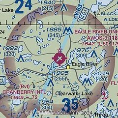
|
| Airport distance calculator |
|---|
|
|
| Sunrise and sunset |
|---|
|
Times for 13-Jul-2026
| | Local
(UTC-5) | | Zulu
(UTC) |
|---|
| Morning civil twilight | | 04:43 | | 09:43 |
| Sunrise | | 05:20 | | 10:20 |
| Sunset | | 20:45 | | 01:45 |
| Evening civil twilight | | 21:22 | | 02:22 |
|
| Current date and time |
|---|
| Zulu (UTC) | 14-Jul-2026 02:47:10 |
|---|
| Local (UTC-5) | 13-Jul-2026 21:47:10 |
|---|
|
| METAR |
|---|
| KEGV | 131935Z AUTO 25010KT 10SM CLR 33/16 A3016 RMK AO2 T03340164
|
KLNL
14nm N | 140235Z AUTO 00000KT 10SM CLR 26/20 A3016 RMK AO2 T02600198
|
KARV
19nm W | 140235Z AUTO 23004KT 10SM CLR 26/22 A3015 RMK AO2 T02610215
|
|
| TAF |
|---|
KRHI
20nm SW | 131726Z 1318/1418 27009G17KT P6SM SKC FM140100 25006KT P6SM SKC FM140500 26006KT P6SM SKC WS020/28035KT FM141200 28008G15KT P6SM SKC
|
|
| NOTAMs |
|---|
NOTAMs are issued by the DoD/FAA and will open in a separate window not controlled by AirNav.
|
|

