FAA INFORMATION EFFECTIVE 30 OCTOBER 2025
Location
| FAA Identifier: | 75K |
| Lat/Long: | 40-16-36.6000N 094-00-26.7000W
40-16.610000N 094-00.445000W
40.2768333,-94.0074167
(estimated) |
| Elevation: | 1035 ft. / 315 m (estimated) |
| Variation: | 04E (1985) |
| From city: | 2 miles NE of BETHANY, MO |
| Time zone: | UTC -6 (UTC -5 during Daylight Saving Time) |
| Zip code: | 64424 |
Airport Operations
| Airport use: | Open to the public |
| Activation date: | 07/1967 |
| Control tower: | no |
| ARTCC: | KANSAS CITY CENTER |
| FSS: | COLUMBIA FLIGHT SERVICE STATION |
| NOTAMs facility: | COU (NOTAM-D service available) |
| Attendance: | UNATNDD |
| Wind indicator: | yes |
| Segmented circle: | yes |
| Lights: | LIRL RY 03/21 THREE CLICKS TO ACTVT CTAF. |
Airport Communications
Nearby radio navigation aids
| VOR radial/distance | | VOR name | | Freq | | Var |
|---|
| LMNr178/19.3 | | LAMONI VOR/DME | | 116.70 | | 07E |
| BQSr348/39.3 | | BRAYMER VOR/DME | | 115.35 | | 03E |
Airport Services
| Parking: | tiedowns |
| Bottled oxygen: | NONE |
| Bulk oxygen: | NONE |
Runway Information
Runway 3/21
| Dimensions: | 2255 x 48 ft. / 687 x 15 m |
| Surface: | asphalt, in poor condition
RY HAS MULTIPLE OPEN CRACKS, PAVEMENT RAVELING AND PRODUCING FOD. |
| Runway edge lights: | non-standard
LIRL NSTD DUE TO INCORRECT SPACING AND NON-FRANGIBLE MOUNTS. |
| Runway edge markings: | RWY 21 MARKINGS FADED
RY 21 NSTD BSC MARKINGS; RY CNTRLN INCORRECT SPACING OF STRIPES & GAPS AT DESIGNATION MARKING & INCORRECT LATERAL SPACING OF DESIGNATION NMBRS. |
| RUNWAY 3 | | RUNWAY 21 |
| Latitude: | 40-16.453333N | | 40-16.767167N |
| Longitude: | 094-00.574667W | | 094-00.315167W |
| Elevation: | 1015.0 ft. | | 1025.0 ft. |
| Traffic pattern: | right | | left |
| Displaced threshold: | no | | 143 ft. |
| Markings: | NSTD, in poor condition | | NSTD, in poor condition |
| Obstructions: | 20 ft. trees, 290 ft. from runway, 85 ft. left of centerline, 4:1 slope to clear
RY 03 +1'-3' GND 0'-200' FM RY END, L & R. | | 22 ft. bldg, 270 ft. from runway, 115 ft. right of centerline, 3:1 slope to clear
+1-51 FT BRUSH; TREES; FENCES; ROADS; UTILITY LINES &POLES 0-200 FT FM RY END L/R. |
Airport Ownership and Management from official FAA records
| Ownership: | Publicly-owned |
| Owner: | CITY OF BETHANY
PO BOX 344
BETHANY, MO 64424
Phone 660-425-3511 |
| Manager: | CITY ADMINISTRATOR
PO BOX 344
BETHANY, MO 64424
Phone 660-425-3511 |
Additional Remarks
| - | NSTD RY SAFETY AREAS BYD EACH RY END; RY 03 INCORRECT TERRAIN GRADIENTS; RY 21 LARGE DROP OFF, BRUSH, SMALL TREES, FENCE AND ROAD. |
| - | FOR CD CTC KANSAS CITY ARTCC AT 913-254-8508. |
Instrument Procedures
There are no published instrument procedures at 75K.
Some nearby airports with instrument procedures:
KLWD - Lamoni Municipal Airport (22 nm N)
KTRX - Trenton Municipal Airport (22 nm SE)
KEZZ - Cameron Memorial Airport (35 nm S)
KCHT - Chillicothe Municipal Airport (38 nm SE)
KEVU - Northwest Missouri Regional Airport (42 nm W)
|
|

Road maps at:
MapQuest
Bing
Google
| Aerial photo |
|---|
WARNING: Photo may not be current or correct

Do you have a better or more recent aerial photo of Bethany Memorial Airport that you would like to share? If so, please send us your photo.
|
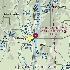
| Sectional chart |
|---|
|
| Airport distance calculator |
|---|
|
|
| Sunrise and sunset |
|---|
|
Times for 15-Nov-2025
| | Local
(UTC-6) | | Zulu
(UTC) |
|---|
| Morning civil twilight | | 06:34 | | 12:34 |
| Sunrise | | 07:03 | | 13:03 |
| Sunset | | 16:58 | | 22:58 |
| Evening civil twilight | | 17:28 | | 23:28 |
|
| Current date and time |
|---|
| Zulu (UTC) | 15-Nov-2025 08:56:40 |
|---|
| Local (UTC-6) | 15-Nov-2025 02:56:40 |
|---|
|
| METAR |
|---|
KLWD
22nm N | 150753Z AUTO 22013KT 10SM CLR 14/13 A2969 RMK AO2 SLP049 T01440128
|
KCDJ
34nm SE | 150751Z AUTO 19005KT 14/13 A2975 RMK AO1 SLP065 T01440128
|
KEZZ
35nm S | 150835Z AUTO 23012KT 10SM CLR 15/14 A2977 RMK AO2
|
KEVU
42nm W | 150835Z AUTO 21008KT 10SM CLR 15/13 A2969 RMK AO2 T01510141
|
|
| NOTAMs |
|---|
NOTAMs are issued by the DoD/FAA and will open in a separate window not controlled by AirNav.
|
|

