FAA INFORMATION EFFECTIVE 27 NOVEMBER 2025
Location
| FAA Identifier: | 87Y |
| Lat/Long: | 43-06-16.9300N 089-11-07.3000W
43-06.282167N 089-11.121667W
43.1047028,-89.1853611
(estimated) |
| Elevation: | 920 ft. / 280.4 m (surveyed) |
| Variation: | 03W (2015) |
| From city: | 10 miles E of MADISON, WI |
| Time zone: | UTC -6 (UTC -5 during Daylight Saving Time) |
| Zip code: | 53527 |
Airport Operations
| Airport use: | Open to the public |
| Activation date: | 09/1972 |
| Control tower: | no |
| ARTCC: | CHICAGO CENTER |
| FSS: | GREEN BAY FLIGHT SERVICE STATION |
| NOTAMs facility: | GRB (NOTAM-D service available) |
| Attendance: | UNATTND |
| Wind indicator: | no |
| Segmented circle: | yes |
| Lights: | SS-SR |
| Beacon: | white-green (lighted land airport)
Operates sunset to sunrise. |
Airport Communications
| CTAF/UNICOM: | 122.7 |
| MADISON APPROACH: | 120.1 |
| MADISON DEPARTURE: | 120.1 |
| WX ASOS at MSN (7 nm W): | PHONE 608-410-1285 |
| WX AWOS-3 at C29 (15 nm W): | 118.675 (608-833-1686) |
- APCH/DEP SVC PRVDD BY CHICAGO ARTCC ON FREQS 133.3/257.925 (LONE ROCK RCAG) WHEN MADISON APCH CTL CLSD.
Nearby radio navigation aids
| VOR radial/distance | | VOR name | | Freq | | Var |
|---|
| MSNr107/7.2 | | MADISON VORTAC | | 108.60 | | 03E |
| JVLr351/33.0 | | JANESVILLE VOR/DME | | 114.30 | | 03E |
| DLLr134/36.8 | | DELLS VORTAC | | 117.00 | | 03E |
| BAEr267/39.5 | | BADGER VOR/DME | | 116.40 | | 02E |
| NDB name | | Hdg/Dist | | Freq | | Var | | ID |
|---|
| ROCK RIVER | | 259/20.6 | | 371 | | 01W | | RYV | .-. -.-- ...- |
Airport Services
| Parking: | hangars and tiedowns |
| Airframe service: | NONE |
| Powerplant service: | NONE |
| Bottled oxygen: | NONE |
| Bulk oxygen: | NONE |
Runway Information
Runway 4/22
| Dimensions: | 2814 x 57 ft. / 858 x 17 m |
| Surface: | asphalt, in poor condition
CRACKS WITH VEGETATION. |
| Runway edge markings: | MARKINGS FADED. |
| RUNWAY 4 | | RUNWAY 22 |
| Latitude: | 43-06.111667N | | 43-06.467500N |
| Longitude: | 089-11.360000W | | 089-10.955333W |
| Elevation: | 914.3 ft. | | 900.7 ft. |
| Traffic pattern: | right | | left |
| Runway heading: | 043 magnetic, 040 true | | 223 magnetic, 220 true |
| Displaced threshold: | no | | 260 ft. |
| Markings: | basic, in poor condition | | basic, in poor condition |
| Touchdown point: | yes, no lights | | yes, no lights |
| Obstructions: | 40 ft. trees, 265 ft. from runway, 55 ft. left of centerline, 1:1 slope to clear
35 FT TREE 45 FT FM THR, 50 FT R. | | 48 ft. trees, 210 ft. from runway, 25 ft. left of centerline, 1:1 slope to clear
45 FT TREES 160 FT FM THR, 25L. |
Runway 9/27
| Dimensions: | 2203 x 56 ft. / 671 x 17 m |
| Surface: | asphalt, in fair condition |
| Runway edge lights: | non-standard
NSTD LIRL; RWY LGTS 2 FT TO 3 FT ABOVE RWY & NSTD SPACING. RWY 09/27 LGTD 1970 FT. |
| Runway edge markings: | MARKINGS FADED. |
| RUNWAY 9 | | RUNWAY 27 |
| Latitude: | 43-06.270000N | | 43-06.275000N |
| Longitude: | 089-11.323333W | | 089-10.828333W |
| Elevation: | 920.0 ft. | | 905.0 ft. |
| Traffic pattern: | left | | right |
| Runway heading: | 092 magnetic, 089 true | | 273 magnetic, 270 true |
| Displaced threshold: | no | | 230 ft. |
| Markings: | basic, in poor condition | | basic, in poor condition |
| Touchdown point: | yes, no lights | | yes, no lights |
| Obstructions: | 15 ft. road, 210 ft. from runway, 1:1 slope to clear
40 FT TREES 180 FT FM THR, 100 FT L. | | 16 ft. road, 317 ft. from runway, 7:1 slope to clear
APCH RATIO 20:1 TO DTHR. |
Airport Ownership and Management from official FAA records
| Ownership: | Privately-owned |
| Owner: | BLACKHAWK AIRFIELD INC
2534 S FISH HATCHERY ROAD
FITCHBURG, WI 53711
Phone (608) 334-4932 |
| Manager: | CHERYL STRASSMAN
2534 S FISH HATCHERY ROAD
FITCHBURG, WI 53711
Phone (608) 334-4932
EMAIL ADDRESS: STRASS32@AMERITECH.NET (ALL LOWER CASE) |
Additional Remarks
| - | RWY 09 AVOID OVERFLIGHT OF FARM 3/4 MI EAST. |
| - | DEER & TURKEYS ON & INVOF ARPT. |
| - | RWY ENDS OBSTD VISUALLY FM OTRS. |
| - | FOR CD CTC MADISON APP/DEP CON AT 608-249-8240. WHEN MADISON APCH CLSD, FOR CD CTC CHICAGO ARTCC AT 630-906-8921. |
| - | COLD TEMPERATURE AIRPORT. ALTITUDE CORRECTION REQUIRED AT OR BELOW -23C. |
Instrument Procedures
NOTE: All procedures below are presented as PDF files. If you need a reader for these files, you should download the free Adobe Reader.NOT FOR NAVIGATION. Please procure official charts for flight.
FAA instrument procedures published for use from 27 November 2025 at 0901Z to 25 December 2025 at 0900Z.
IAPs - Instrument Approach Procedures |
|---|
| VOR OR GPS-A | |
download (197KB) |
| NOTE: Special Take-Off Minimums/Departure Procedures apply | |
download (485KB) |
Other nearby airports with instrument procedures:
KMSN - Dane County Regional Airport-Truax Field (7 nm W)
C29 - Middleton Municipal Airport - Morey Field (15 nm W)
61C - Fort Atkinson Municipal Airport (18 nm SE)
KRYV - Watertown Municipal Airport (21 nm E)
91C - Sauk/Prairie Airport (28 nm NW)
|
|

Road maps at:
MapQuest
Bing
Google
| Aerial photo |
|---|
WARNING: Photo may not be current or correct

Do you have a better or more recent aerial photo of Blackhawk Airfield that you would like to share? If so, please send us your photo.
|
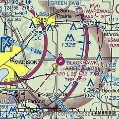
| Sectional chart |
|---|
|
| Airport distance calculator |
|---|
|
|
| Sunrise and sunset |
|---|
|
Times for 15-Dec-2025
| | Local
(UTC-6) | | Zulu
(UTC) |
|---|
| Morning civil twilight | | 06:50 | | 12:50 |
| Sunrise | | 07:22 | | 13:22 |
| Sunset | | 16:21 | | 22:21 |
| Evening civil twilight | | 16:54 | | 22:54 |
|
| Current date and time |
|---|
| Zulu (UTC) | 15-Dec-2025 07:23:39 |
|---|
| Local (UTC-6) | 15-Dec-2025 01:23:39 |
|---|
|
| METAR |
|---|
KMSN
7nm W | 150653Z AUTO 19009KT 10SM OVC080 M16/M21 A3034 RMK AO2 SLP298 T11561211 $
|
KC29
15nm W | 150655Z AUTO 21008KT 10SM SCT080 M14/M22 A3034 RMK AO1 T11451220
|
|
| TAF |
|---|
KMSN
7nm W | 150523Z 1506/1606 21010KT P6SM BKN120 BKN250 WS020/22045KT FM151100 21012G24KT P6SM OVC150 WS020/22045KT FM151400 22011G23KT P6SM FEW030 BKN200 FM151800 25009KT P6SM BKN230 FM152300 24005KT P6SM SCT230
|
|
| NOTAMs |
|---|
NOTAMs are issued by the DoD/FAA and will open in a separate window not controlled by AirNav.
|
|

