FAA INFORMATION EFFECTIVE 09 JULY 2026
Location
| FAA Identifier: | 9G8 |
| Lat/Long: | 40-27-40.5150N 078-46-31.1210W
40-27.675250N 078-46.518683W
40.4612542,-78.7753114
(estimated) |
| Elevation: | 2099 ft. / 639.8 m (surveyed) |
| Variation: | 09W (1985) |
| From city: | 3 miles SW of EBENSBURG, PA |
| Time zone: | UTC -4 (UTC -5 during Standard Time) |
| Zip code: | 15931 |
Airport Operations
| Airport use: | Open to the public |
| Activation date: | 09/1938 |
| Control tower: | no |
| ARTCC: | CLEVELAND CENTER |
| FSS: | ALTOONA FLIGHT SERVICE STATION |
| NOTAMs facility: | AOO (NOTAM-D service available) |
| Attendance: | IREG |
| Wind indicator: | lighted |
| Segmented circle: | yes |
| Lights: | ACTVT MIRL RWY 07/25 & TWY LGTS - CTAF. |
| Beacon: | white-green (lighted land airport)
Operates sunset to sunrise. |
Airport Communications
| CTAF/UNICOM: | 122.8 |
| JOHNSTOWN APPROACH: | 121.2 |
| JOHNSTOWN DEPARTURE: | 121.2 |
| WX ASOS at JST (9 nm S): | PHONE 814-535-3511 |
| WX AWOS-3 at IDI (18 nm NW): | 126.625 (724-388-0204) |
- APCH/DEP SVC PRVDD BY CLEVELAND ARTCC (ZOB) ON FREQS 124.4/299.2 (ALTOONA RCAG) WHEN JOHNSTOWN APCH CTL CLSD.
Nearby radio navigation aids
| VOR radial/distance | | VOR name | | Freq | | Var |
|---|
| JSTr023/9.1 | | JOHNSTOWN VOR/DME | | 113.00 | | 06W |
Airport Services
| Fuel available: | 100LL
100LL:24 HR SELF-SERVE FUEL AVBL. |
| Parking: | tiedowns |
| Airframe service: | NONE |
| Powerplant service: | NONE |
| Bottled oxygen: | NONE |
| Bulk oxygen: | NONE |
Runway Information
Runway 7/25
| Dimensions: | 3204 x 50 ft. / 977 x 15 m |
| Surface: | asphalt, in good condition |
| Weight bearing capacity: | |
| Runway edge lights: | medium intensity |
| Runway edge markings: | BSC RWY MARKINGS |
| RUNWAY 7 | | RUNWAY 25 |
| Latitude: | 40-27.527300N | | 40-27.817250N |
| Longitude: | 078-46.722217W | | 078-46.145083W |
| Elevation: | 2080.0 ft. | | 2098.0 ft. |
| Traffic pattern: | left | | left |
| Runway heading: | 066 magnetic, 057 true | | 246 magnetic, 237 true |
| Markings: | NSTD, in good condition | | NSTD, in good condition |
| Touchdown point: | yes, no lights | | yes, no lights |
| Obstructions: | 55 ft. trees, 900 ft. from runway, 269 ft. right of centerline, 12:1 slope to clear | | 13 ft. trees, 312 ft. from runway, 134 ft. right of centerline, 8:1 slope to clear |
Runway 11U/29U
| Dimensions: | 1636 x 150 ft. / 499 x 46 m |
| Surface: | turf/dirt, in fair condition |
| Runway edge markings: | RWY 11U/29U RWY BOUNDARY MKD WITH YELLOW CONES. |
| Operational restrictions: | RWY 11U/29U FOR ULTRALIGHT USE ONLY. |
| RUNWAY 11U | | RUNWAY 29U |
| Latitude: | 40-27.700833N | | 40-27.661250N |
| Longitude: | 078-46.859667W | | 078-46.510667W |
| Elevation: | 2063.0 ft. | | 2094.0 ft. |
| Traffic pattern: | left | | left |
| Runway heading: | 107 magnetic, 098 true | | 287 magnetic, 278 true |
| Touchdown point: | yes, no lights | | yes, no lights |
| Obstructions: | none | | 52 ft. tree, 678 ft. from runway, 19 ft. left of centerline, 13:1 slope to clear |
Airport Ownership and Management from official FAA records
| Ownership: | Publicly-owned |
| Owner: | BOROUGH OF EBENSBURG
300 W HIGH ST
EBENSBURG, PA 15931
Phone (814) 472-0843 |
| Manager: | BILL GRADY
3920 ADMIRAL PEARY HIGHWAY
EBENSBURG, PA 15931
Phone 202-262-6593 |
Additional Remarks
| - | DEER ON & INVOF ARPT. |
| - | FOR CD CTC JOHNSTOWN APCH AT 814-532-5960, WHEN APCH CLSD CTC CLEVELAND ARTCC AT 440-774-0213. |
Instrument Procedures
NOTE: All procedures below are presented as PDF files. If you need a reader for these files, you should download the free Adobe Reader.NOT FOR NAVIGATION. Please procure official charts for flight.
FAA instrument procedures published for use from 09 July 2026 at 0901Z to 06 August 2026 at 0900Z.
IAPs - Instrument Approach Procedures |
|---|
| RNAV (GPS) RWY 07 | |
download (184KB) |
| RNAV (GPS) RWY 25 | |
download (184KB) |
| NOTE: Special Take-Off Minimums/Departure Procedures apply | |
download (209KB) |
Other nearby airports with instrument procedures:
KJST - John Murtha Johnstown/Cambria County Airport (9 nm S)
KIDI - Indiana County Airport (Jimmy Stewart Field) (18 nm NW)
KAOO - Altoona/Blair County Airport (23 nm SE)
KHMZ - Bedford County Airport (26 nm SE)
2G9 - Somerset County Airport (28 nm SW)
|
|

Road maps at:
MapQuest
Bing
Google
| Aerial photo |
|---|
WARNING: Photo may not be current or correct
 Photo taken 10-Nov-2020
looking southwest.
Photo taken 10-Nov-2020
looking southwest.
Do you have a better or more recent aerial photo of Ebensburg Airport that you would like to share? If so, please send us your photo.
|
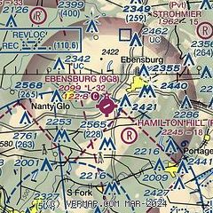
| Sectional chart |
|---|
|
| Airport distance calculator |
|---|
|
|
| Sunrise and sunset |
|---|
|
Times for 22-Jul-2026
| | Local
(UTC-4) | | Zulu
(UTC) |
|---|
| Morning civil twilight | | 05:33 | | 09:33 |
| Sunrise | | 06:04 | | 10:04 |
| Sunset | | 20:39 | | 00:39 |
| Evening civil twilight | | 21:10 | | 01:10 |
|
| Current date and time |
|---|
| Zulu (UTC) | 22-Jul-2026 13:25:40 |
|---|
| Local (UTC-4) | 22-Jul-2026 09:25:40 |
|---|
|
| METAR |
|---|
KJST
9nm S | 221301Z AUTO 30008KT 1 3/4SM RA BR BKN006 OVC013 17/16 A2990 RMK AO2 VIS 1 1/4V4 CIG 004V009 P0002 T01670161
|
KIDI
17nm NW | 221255Z AUTO 31011G17KT 10SM SCT010 BKN015 OVC043 18/16 A2990 RMK A01
|
|
| TAF |
|---|
KJST
9nm S | 221159Z 2212/2312 30008KT P6SM BKN009 OVC015 FM221400 29009G14KT P6SM SCT012 BKN025 FM221700 29011G19KT P6SM SCT035 BKN250 FM222200 31009KT P6SM SCT250
|
|
| NOTAMs |
|---|
NOTAMs are issued by the DoD/FAA and will open in a separate window not controlled by AirNav.
|
|

