FAA INFORMATION EFFECTIVE 27 NOVEMBER 2025
Location
| FAA Identifier: | AOO |
| Lat/Long: | 40-17-46.9000N 078-19-12.1000W
40-17.781667N 078-19.201667W
40.2963611,-78.3200278
(estimated) |
| Elevation: | 1503.4 ft. / 458.2 m (surveyed) |
| Variation: | 10W (2005) |
| From city: | 12 miles S of ALTOONA, PA |
| Time zone: | UTC -5 (UTC -4 during Daylight Saving Time) |
| Zip code: | 16662 |
Airport Operations
| Airport use: | Open to the public |
| Activation date: | 12/1937 |
| Control tower: | no |
| ARTCC: | CLEVELAND CENTER |
| FSS: | ALTOONA FLIGHT SERVICE STATION |
| NOTAMs facility: | AOO (NOTAM-D service available) |
| Attendance: | MON-FRI 0430-2230, ALL SAT 0730-1930, ALL SUN 0830-2030 |
| Wind indicator: | lighted |
| Segmented circle: | yes |
| Lights: | HIRL RY 03/21 & MIRL RY 12/30 PRESET LOW INTST, INCR INTST & ACTVT PAPI RYS 12, 30, 03 & 21, MALSR RY 21 & REIL RYS 03, 12, & 30 - CTAF. |
| Beacon: | white-green (lighted land airport)
Operates sunset to sunrise. |
| Fire and rescue: | ARFF index A |
| Airline operations: | PPR 24 FOR UNSKED ACR & NON-ACR OPNS WITH MORE THAN 30 PSGR SEATS; CALL AMGR 814-793-2027. |
Airport Communications
| CTAF: | 123.6 |
| WX ASOS: | 127.125 (814-793-9655) |
| JOHNSTOWN APPROACH: | 121.2 |
| JOHNSTOWN DEPARTURE: | 121.2 |
| WX AWOS-3 at HMZ (15 nm SW): | 123.675 (814-623-2936) |
- APCH/DEP SVC PRVDD BY CLEVELAND ARTCC (ZOB) ON FREQS 124.4/299.2 (ALTOONA RCAG) WHEN JOHNSTOWN APCH CTL CLSD.
Nearby radio navigation aids
| VOR radial/distance | | VOR name | | Freq | | Var |
|---|
| JSTr099/23.6 | | JOHNSTOWN VOR/DME | | 113.00 | | 06W |
Airport Services
| Fuel available: | 100LL JET-A |
| Parking: | hangars and tiedowns |
| Airframe service: | MAJOR |
| Powerplant service: | MAJOR |
| Bottled oxygen: | HIGH |
| Bulk oxygen: | HIGH |
Runway Information
Runway 3/21
| Dimensions: | 5465 x 100 ft. / 1666 x 30 m |
| Surface: | asphalt/grooved, in good condition |
| Weight bearing capacity: | | PCN 13 /F/B/X/T | | Single wheel: | 16.0 | | Double wheel: | 44.0 |
|
| Runway edge lights: | high intensity
RY 03/21, THRESHOLD LGTS & EDGE LGTS OTS EXCEPT WITH PCL, AVBL FM 0100-1300Z DAILY. |
| RUNWAY 3 | | RUNWAY 21 |
| Latitude: | 40-17.323235N | | 40-18.188523N |
| Longitude: | 078-19.387697W | | 078-19.064057W |
| Elevation: | 1503.4 ft. | | 1469.3 ft. |
| Traffic pattern: | left | | left |
| Runway heading: | 026 magnetic, 016 true | | 206 magnetic, 196 true |
| Declared distances: | TORA:5465 TODA:5465 ASDA:5465 LDA:5465 | | TORA:5465 TODA:5465 ASDA:5465 LDA:5465 |
| Markings: | nonprecision, in good condition | | precision, in good condition |
| Visual slope indicator: | 4-light PAPI on left (3.00 degrees glide path) | | 4-light PAPI on left (3.00 degrees glide path) |
| Approach lights: | | | MALSR: 1,400 foot medium intensity approach lighting system with runway alignment indicator lights |
| Runway end identifier lights: | yes | | |
| Touchdown point: | yes, no lights | | yes, no lights |
| Instrument approach: | | | ILS |
| Obstructions: | 46 ft. trees, 886 ft. from runway, 522 ft. left of centerline, 14:1 slope to clear | | 72 ft. tree, 1950 ft. from runway, 685 ft. right of centerline, 24:1 slope to clear |
Runway 12/30
| Dimensions: | 3668 x 75 ft. / 1118 x 23 m |
| Surface: | asphalt, in good condition |
| Weight bearing capacity: | | PCN 11 /F/B/X/T | | Single wheel: | 11.5 | | Double wheel: | 33.0 |
|
| Runway edge lights: | medium intensity
RY 12/30, THRESHOLD LGTS & EDGE LGTS OTS EXCEPT WITH PCL, AVBL FM 0100-1300Z DAILY. |
| Operational restrictions: | RWY 12/30 NOT AVBL FOR PART 121/PART 380 OPS WITH SKED PAX CARRYING OPS MORE THAN 9 PAX SEATS AND NON-SKED PAX CARRYING OPS MORE THAN 30 PAX SEATS. NO PART 121/PART 380 OPS EXC FOR TAX. |
| RUNWAY 12 | | RUNWAY 30 |
| Latitude: | 40-17.915890N | | 40-17.726020N |
| Longitude: | 078-19.538380W | | 078-18.789473W |
| Elevation: | 1472.8 ft. | | 1481.5 ft. |
| Traffic pattern: | left | | left |
| Runway heading: | 118 magnetic, 108 true | | 298 magnetic, 288 true |
| Declared distances: | TORA:3668 TODA:3668 ASDA:3668 LDA:3668 | | TORA:3668 TODA:3668 ASDA:3668 LDA:3668 |
| Markings: | basic, in good condition | | nonprecision, in good condition |
| Visual slope indicator: | 4-light PAPI on left (3.00 degrees glide path) | | 4-light PAPI on right (4.00 degrees glide path) |
| Runway end identifier lights: | yes | | yes |
| Touchdown point: | yes, no lights | | yes, no lights |
| Obstructions: | 7 ft. tree, 260 ft. from runway, 82 ft. right of centerline, 8:1 slope to clear | | 15 ft. trees, 397 ft. from runway, 59 ft. right of centerline, 13:1 slope to clear
HAS + 4 FT GND 20 FT FM RY END 215 FT RIGHT. |
Airport Ownership and Management from official FAA records
| Ownership: | Publicly-owned |
| Owner: | BLAIR COUNTY AIRPORT AUTH
310 AIRPORT DRIVE, SUITE 6
MARTINSBURG, PA 16662
Phone 814-793-2027 |
| Manager: | TRACY PLESSINGER
310 AIRPORT DRIVE, SUITE 6
MARTINSBURG, PA 16662
Phone 814-793-2027 |
Additional Remarks
| - | PREFERRED RWY IS RWY 21; FOR NOISE ABATEMENT WHEN DEP RWY 03 MAINT RWY HDG TIL 2 NM N OF ARPT. |
| - | SPECIALIZED ACFT (ULTRALGT, HOMEBUILT, ETC) CTC AMGR 814-793-2027 OR UNICOM PRIOR TO LDG. |
| - | RWY/TWY CONDITIONS UNMONITORED OUTSIDE OF NML ATTENDANCE HRS. |
| - | FOR CD CTC JOHNSTOWN APCH AT 814-532-5960, WHEN APCH CLSD CTC CLEVELAND ARTCC AT 440-774-0213. |
Instrument Procedures
NOTE: All procedures below are presented as PDF files. If you need a reader for these files, you should download the free Adobe Reader.NOT FOR NAVIGATION. Please procure official charts for flight.
FAA instrument procedures published for use from 27 November 2025 at 0901Z to 25 December 2025 at 0900Z.
IAPs - Instrument Approach Procedures |
|---|
| ILS OR LOC RWY 21 | |
download (253KB) |
| RNAV (GPS) RWY 21 | |
download (239KB) |
| RNAV (GPS) Y RWY 03 | |
download (260KB) |
| RNAV (GPS) Z RWY 03 | |
download (228KB) |
| NOTE: Special Alternate Minimums apply | |
download (145KB) |
| NOTE: Special Take-Off Minimums/Departure Procedures apply | |
download (427KB) |
Other nearby airports with instrument procedures:
KHMZ - Bedford County Airport (15 nm SW)
9G8 - Ebensburg Airport (23 nm NW)
KJST - John Murtha Johnstown/Cambria County Airport (24 nm W)
2G9 - Somerset County Airport (35 nm SW)
N68 - Franklin County Regional Airport (37 nm SE)
|
|

Road maps at:
MapQuest
Bing
Google
| Aerial photo |
|---|
WARNING: Photo may not be current or correct
 Photo by David Newcomer
Taken in June 2009
Photo by David Newcomer
Taken in June 2009
Do you have a better or more recent aerial photo of Altoona/Blair County Airport that you would like to share? If so, please send us your photo.
|
| Sectional chart |
|---|
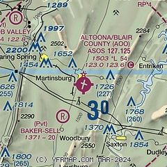
|
| Airport distance calculator |
|---|
|
|
| Sunrise and sunset |
|---|
|
Times for 22-Dec-2025
| | Local
(UTC-5) | | Zulu
(UTC) |
|---|
| Morning civil twilight | | 07:03 | | 12:03 |
| Sunrise | | 07:34 | | 12:34 |
| Sunset | | 16:50 | | 21:50 |
| Evening civil twilight | | 17:20 | | 22:20 |
|
| Current date and time |
|---|
| Zulu (UTC) | 22-Dec-2025 09:36:26 |
|---|
| Local (UTC-5) | 22-Dec-2025 04:36:26 |
|---|
|
| METAR |
|---|
| KAOO | 220853Z AUTO 00000KT 10SM CLR M06/M12 A3046 RMK AO2 SLP335 T10561117 50009
|
KHMZ
15nm SW | 220915Z AUTO 00000KT 10SM CLR M06/M11 A3048 RMK AO2 T10611113
|
|
| TAF |
|---|
| KAOO | 220521Z 2206/2306 VRB03KT P6SM SKC FM220900 26003KT P6SM SKC FM221800 24006KT P6SM BKN150 FM222100 24006KT P6SM BKN060 OVC110 FM230500 32002KT P6SM OVC050
|
|
| NOTAMs |
|---|
NOTAMs are issued by the DoD/FAA and will open in a separate window not controlled by AirNav.
|
|


